
-
Sentinel-6A MF Jason-CS L1B GNSS-POD Tracking Data Hourly
Provides L1B hourly GNSS-POD tracking data for the Sentinel-6A radar altimetry mission. -
Labrador Sea Pre-SWOT Level-4 Hourly MITgcm LLC4320 Native Grid 2km Oceanographic Dataset Version 1.0
This dataset provides a regional multivariate oceanographic state estimate from a global ocean numerical simulation with a focus on the Labrador Sea region. The global ocean... -
Integrated Multi-Mission Ocean Altimeter Data for Climate Research complete time series Version 5.2
The Integrated Multi-Mission Ocean Altimeter Sea Surface Height (SSH) Version 5.2 dataset provides level 2 along track sea surface height anomalies (SSHA) from the... -
SASSIE Arctic Field Campaign Shipboard uCTD Data Fall 2022 Version 1
The Salinity and Stratification at the Sea Ice Edge (SASSIE) project is a NASA experiment that aims to understand how salinity anomalies in the upper ocean generated by melting... -
SASSIE Arctic Field Campaign SWIFT Data Fall 2022 Version 1
The Salinity and Stratification at the Sea Ice Edge (SASSIE) project is a NASA experiment that aims to understand how salinity anomalies in the upper ocean generated by melting... -
S-MODE Shipboard uCTD and EcoCTD Measurements Version 1
This dataset contains shipboard Underway conductivity, temperature, and depth (UCDT) measurements taken during the Sub-Mesoscale Ocean Dynamics Experiment (S-MODE) field... -
S-MODE Pre-Pilot Level 1 Data from the Ka-band Ocean Doppler Scatterometer (KaBODS) at the Air-Sea Interaction Tower Version 1
This data set includes tower-based Ka-band ocean surface backscatter measurements (cross section, incidence angle, radial velocity from radar, pulse-pair correlation) located... -
SWOT 2019-2020 Prelaunch Oceanography Field Campaign Rutgers Slocum Gliders
This dataset provides the Conductivity, Temperature, and Depth measurements carried by a Slocum glider. The measurements were collected during the 2019-2020 SWOT prelaunch field... -
SWOT 2019-2020 Prelaunch Oceanography Field Campaign NOAA Prawlers
This dataset provides the conductivity, temperature and depth (CTD) profiles from a Prawler profiler mooring deployed by the SWOT prelaunch field campaign. The campaign was... -
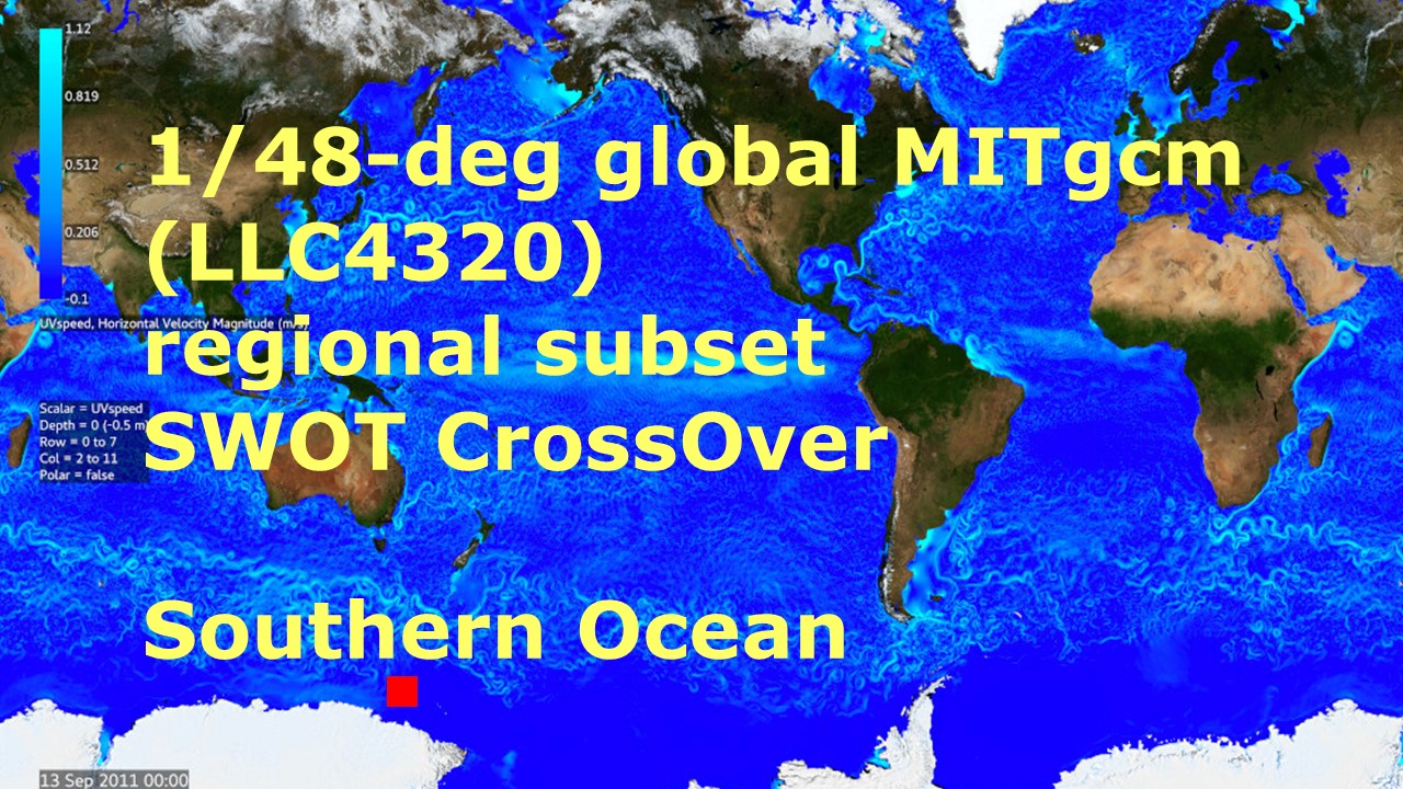
Southern Ocean Pre-SWOT Level-4 Hourly MITgcm LLC4320 Native Grid 2km Oceanographic Dataset Version 1.0
This dataset provides a regional multivariate oceanographic state estimate from a global ocean numerical simulation with a focus on the Southern Ocean region. The global ocean... -
GHRSST Level 4 REMO_OI_SST_5km Regional Foundation Sea Surface Temperature Analysis (GDS version 2)
A Group for High Resolution Sea Surface Temperature (GHRSST) Level 4 sea surface temperature (SST) analysis produced daily on an operational basis by the Oceanographic Modeling... -
OMG Narwhals Shipboard Conductivity, Temperature, and Depth (CTD) profiles, 2018-2020
This OMG Narwhals dataset contains measurements from the ship based full water column CTD profiles that were obtained during summer mooring deployment/recovery cruises. NASA’s... -
SWOT Level 2 Nadir Altimeter Operational Geophysical Data Record with Waveforms - GDR, Version 2.0
Same as L2_NALT_GDR using predicted values for some auxiliary data, and does not have GIM ionosphere model values. Uses the onboard DORIS orbit ephemeris. Available with latency... -
Sentinel-6A MF Jason-CS L2 P4 Altimeter High Resolution (HR) STC Ocean Surface Topography
Provides L2 high resolution (HR) short time critical (STC; 36-hour latency) altimetry from the Poseidon-4 SAR altimeter on the Sentinel-6A Michael Freilich spacecraft. It... -
SASSIE Arctic Field Campaign Shipboard Castaway CTD Data Fall 2022 Version 1
The Salinity and Stratification at the Sea Ice Edge (SASSIE) project is a NASA experiment that aims to understand how salinity anomalies in the upper ocean generated by melting... -
Northwest Australian Shelf Pre-SWOT Level-4 Hourly MITgcm LLC4320 Native Grid 2km Oceanographic Dataset Version 1.0
This dataset provides a regional multivariate oceanographic state estimate from a global ocean numerical simulation with a focus on the Northwest Australian Shelf region. The... -
SWOT 2019-2020 Prelaunch Oceanography Field Campaign WHOI/NOAA Moored Fixed-Depth CTDs
This dataset provides the conductivity, temperature and depth (CTD) measurements from the fixed-depth CTD sensors mounted on a full-depth mooring deployed by the SWOT prelaunch... -
SWOT Level 2 Radiometer Brightness Temperatures and Troposphere Operational Data Product Version 1.0
The SWOT Level 2 Radiometer Brightness Temperatures and Troposphere Operational Geophysical Data Record (OGDR) Version 1.0 dataset produced by the Surface Water and Ocean... -
MetOp-A ASCAT Level 2 Ocean Surface Wind Vectors Optimized for Coastal Ocean
This dataset contains operational near-real-time Level 2 coastal ocean surface wind vector retrievals from the Advanced Scatterometer (ASCAT) on MetOp-A at 12.5 km sampling... -
Gotland Basin Pre-SWOT Level-4 Hourly MITgcm LLC4320 Native Grid 2km Oceanographic Dataset Version 1.0
This dataset provides a regional multivariate oceanographic state estimate from a global ocean numerical simulation with a focus on the Gotland Basin region. The global ocean...

Official websites use .gov
A
.gov website belongs to an official government
organization in the United States.
Secure .gov websites use HTTPS
A
lock (
) or https:// means you’ve safely connected to
the .gov website. Share sensitive information only on official,
secure websites.