
-
SWOT Level 2 Water Mask Pixel Cloud Auxiliary Data Product, Version 2.0
Auxiliary information for pixel cloud product indicating to which water bodies the pixels are assigned in river and lake products. Also includes height-constrained pixel... -
RSS SMAP Level 3 Sea Surface Salinity Standard Mapped Image 8-Day Running Mean V5.3 Validated Dataset
The RSS SMAP Level 3 Sea Surface Salinity Standard Mapped Image 8-Day Running Mean V5.3 Validated Dataset produced by the Remote Sensing Systems (RSS) and sponsored by the NASA... -
SWOT Level 2 Nadir Altimeter Interim Geophysical Data Record with Waveforms - GDR, Version 2.0
Same as L2_NALT_GDR, using preliminary values for some auxiliary data. Uses Medium-accuracy (preliminary) Orbit Ephemeris (MOE). Available with latency of < 1.5 days.... -
SWOT Level 2 Nadir Altimeter Interim Geophysical Data Record with Waveforms - SSHA, Version 2.0
Same as L2_NALT_GDR, using preliminary values for some auxiliary data. Uses Medium-accuracy (preliminary) Orbit Ephemeris (MOE). Available with latency of < 1.5 days.... -
SWOT Level 2 Lake Single-Pass Vector Obs Data Product, Version 2.0
The SWOT Level 2 Lake Single-Pass Vector Obs Data Product from the Surface Water Ocean Topography (SWOT) mission provides water surface elevation, area, storage change derived... -
SWOT Level 2 Water Mask Raster Image 100m Data Product, Version 2.0
The SWOT Level 2 Water Mask Raster Image 100m Data Product from the Surface Water Ocean Topography (SWOT) mission provides global surface water elevation and inundation extent... -
SWOT Level 2 Nadir Altimeter Geophysical Data Record with Waveforms - SSHA
The SWOT Level 2 Nadir Altimeter Geophysical Data Record (GDR) with Waveforms dataset produced by the Surface Water and Ocean Topography (SWOT) mission provides sea surface... -
MetOp-B ASCAT Level 2 25.0km Ocean Surface Wind Vectors in Full Orbit Swath
This dataset contains operational near-real-time Level 2 ocean surface wind vector retrievals from the Advanced Scatterometer (ASCAT) on MetOp-B at 25 km sampling resolution... -
SWOT Level 2 Nadir Altimeter Interim Geophysical Data Record with Waveforms, Version 2.0
The SWOT Level 2 Nadir Altimeter Interim Geophysical Data Record (IGDR) Version 1.0 dataset produced by the Surface Water and Ocean Topography (SWOT) mission provides sea... -
MetOp-C ASCAT Level 2 25.0km Ocean Surface Wind Vectors in Full Orbit Swath
This dataset contains operational near-real-time Level 2 ocean surface wind vector retrievals from the Advanced Scatterometer (ASCAT) on MetOp-C at 25 km sampling resolution... -
SWOT Level 2 Nadir Altimeter Interim Geophysical Data Record with Waveforms - SGDR Version 1.0
Same as L2_NALT_GDR, using preliminary values for some auxiliary data. Uses Medium-accuracy (preliminary) Orbit Ephemeris (MOE). Available with latency of < 1.5 days.... -
SWOT Level 2 River Cycle-Averaged Data Product, Version 2.0
Cycle average and aggregation of river reach pass data within predefined hydrological basins. Basin for each cycle. Available in Shapefile file format. -
SWOT Level 2 Nadir Altimeter Interim Geophysical Data Record with Waveforms - GDR Version 1.0
Same as L2_NALT_GDR, using preliminary values for some auxiliary data. Uses Medium-accuracy (preliminary) Orbit Ephemeris (MOE). Available with latency of < 1.5 days.... -
SPURS-2 shipboard X-band radar backscatter data for the E. Tropical Pacific field campaign
The SPURS-2 X-band marine navigation radar image dataset was collected from the ship during both the 2016 and 2017 cruises. The dataset consists of screenshots of rain echoes... -
Sentinel-6A MF Jason-CS L1B GNSS-RO-POD Tracking Data Hourly
Provides L1B GNSS-RO-POD tracking data for the Sentinel-6A radar altimetry mission. -
Sentinel-6A MF Jason-CS L1B GNSS-POD Tracking Data Daily
Provides L1B daily GNSS-POD tracking data for the Sentinel-6A radar altimetry mission. -
Sentinel-6A MF Jason-CS L1B GNSS-POD Tracking Data Hourly
Provides L1B hourly GNSS-POD tracking data for the Sentinel-6A radar altimetry mission. -
Labrador Sea Pre-SWOT Level-4 Hourly MITgcm LLC4320 Native Grid 2km Oceanographic Dataset Version 1.0
This dataset provides a regional multivariate oceanographic state estimate from a global ocean numerical simulation with a focus on the Labrador Sea region. The global ocean... -
Integrated Multi-Mission Ocean Altimeter Data for Climate Research complete time series Version 5.2
The Integrated Multi-Mission Ocean Altimeter Sea Surface Height (SSH) Version 5.2 dataset provides level 2 along track sea surface height anomalies (SSHA) from the... -
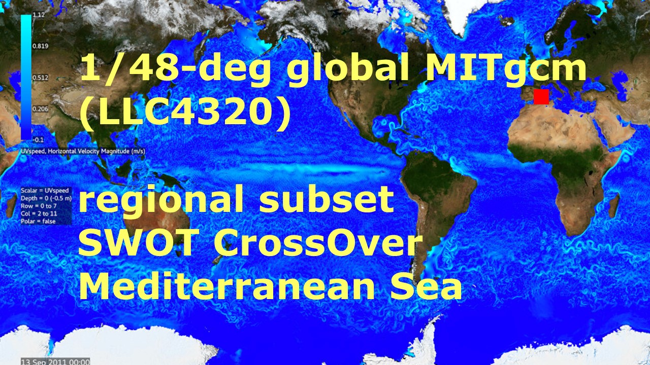
Mediterranean Sea Pre-SWOT Level-4 Hourly MITgcm LLC4320 Native Grid 2km Oceanographic Dataset Version 1.0
This dataset provides a regional multivariate oceanographic state estimate from a global ocean numerical simulation with a focus on the western Mediterranean Sea region. The...

Official websites use .gov
A
.gov website belongs to an official government
organization in the United States.
Secure .gov websites use HTTPS
A
lock (
) or https:// means you’ve safely connected to
the .gov website. Share sensitive information only on official,
secure websites.