
-
GPM IMERG Final Precipitation L3 Half Hourly 0.1 degree x 0.1 degree V07 (GPM_3IMERGHH) at GES DISC recent views
Version 07 is the current version of the data set. Older versions will no longer be available and have been superseded by Version 07. The Integrated Multi-satellitE Retrievals... -
TRMM (TMPA) Rainfall Estimate L3 3 hour 0.25 degree x 0.25 degree V7 (TRMM_3B42) at GES DISC recent views
TMPA (3B42) dataset have been discontinued as of Dec. 31, 2019, and users are strongly encouraged to shift to the successor IMERG dataset (doi: 10.5067/GPM/IMERG/3B-HH/06). This... -
OMI/Aura Near UV Aerosol Optical Depth and Single Scattering Albedo 1-orbit L2 Swath 13x24 km V004 (OMAERUV) at GES DISC recent views
The Aura Ozone Monitoring Instrument level-2 near UV Aerosol data product OMAERUV (Version 004) is available from the NASA Goddard Earth Sciences Data and Information Services... -
OCO-2 GEOS Level 3 daily, 0.5x0.625 assimilated CO2 V10r (OCO2_GEOS_L3CO2_DAY) at GES DISC recent views
This is the Gridded Daily OCO-2 Carbon Dioxide assimilated dataset. The OCO-2 mission provides the highest quality space-based XCO2 retrievals to date. However, the instrument... -
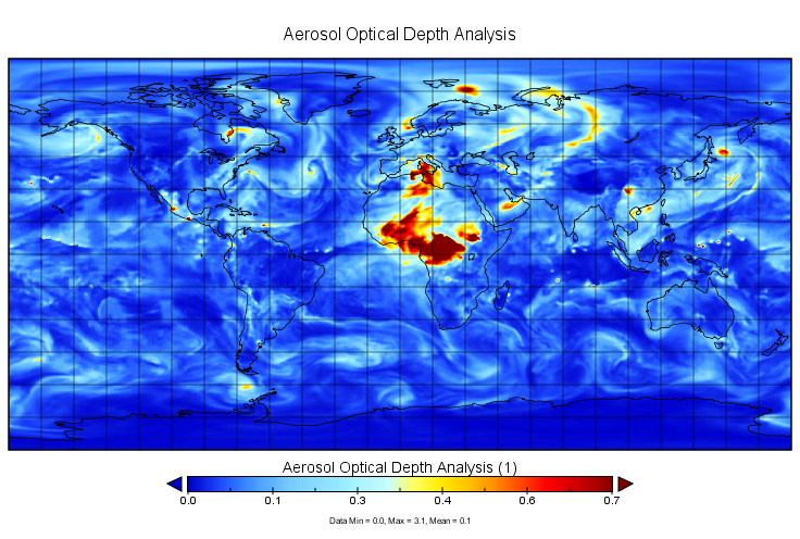
MERRA-2 inst3_2d_gas_Nx: 2d,3-Hourly,Instantaneous,Single-Level,Assimilation,Aerosol Optical Depth Analysis 0.625 x 0.5 degree V5.12.4 (M2I3NXGAS) at GES DISC recent views
M2I3NXGAS (or inst3_3d_gas_Nx) is an instantaneous 2-dimensional 3-hourly data collection in Modern-Era Retrospective analysis for Research and Applications version 2 (MERRA-2).... -
MERRA-2 tavg1_2d_slv_Nx: 2d,1-Hourly,Time-Averaged,Single-Level,Assimilation,Single-Level Diagnostics 0.625 x 0.5 degree V5.12.4 (M2T1NXSLV) at GES DISC recent views
M2T1NXSLV (or tavg1_2d_slv_Nx) is an hourly time-averaged 2-dimensional data collection in Modern-Era Retrospective analysis for Research and Applications version 2 (MERRA-2).... -
FLDAS Noah Land Surface Model L4 Global Monthly 0.1 x 0.1 degree (MERRA-2 and CHIRPS) V001 (FLDAS_NOAH01_C_GL_M) at GES DISC recent views
This dataset contains a series of land surface parameters simulated from the Noah 3.6.1 model in the Famine Early Warning Systems Network (FEWS NET) Land Data Assimilation... -
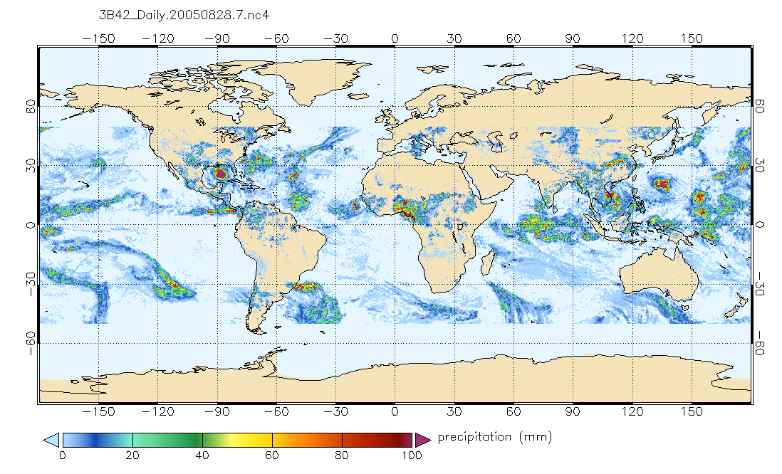
TRMM (TMPA) Precipitation L3 1 day 0.25 degree x 0.25 degree V7 (TRMM_3B42_Daily) at GES DISC recent views
TMPA (3B42_Daily) dataset have been discontinued as of Dec. 31, 2019, and users are strongly encouraged to shift to the successor IMERG dataset (doi:... -
GPM IMERG Final Precipitation L3 1 month 0.1 degree x 0.1 degree V07 (GPM_3IMERGM) at GES DISC recent views
Version 07 is the current version of the data set. Older versions will no longer be available and have been superseded by Version 07. The Integrated Multi-satellitE Retrievals... -
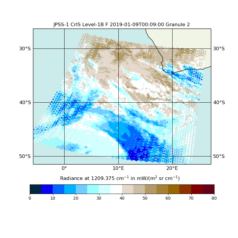
JPSS-1 CrIS Level 1B Full Spectral Resolution V2 (SNDRJ1CrISL1B) at GES DISC recent views
The Cross-track Infrared Sounder (CrIS) Level 1B Full Spectral Resolution (FSR) data files contain radiance measurements along with ancillary spacecraft, instrument, and... -
GLDAS Noah Land Surface Model L4 monthly 0.25 x 0.25 degree V2.1 (GLDAS_NOAH025_M) at GES DISC recent views
NASA Global Land Data Assimilation System Version 2 (GLDAS-2) has three components: GLDAS-2.0, GLDAS-2.1, and GLDAS-2.2. GLDAS-2.0 is forced entirely with the Princeton... -
Annual Summary of Artificial Light At Night from VIIRS/S-NPP at CONUS County and Census Tract V1 (ALAN_VIIRS_CONUS) at GES DISC recent views
This product provides detailed information about the satellite-based data on artificial light at night (ALAN). The Suomi National Polar-orbiting Partnership (S-NPP) Visible... -
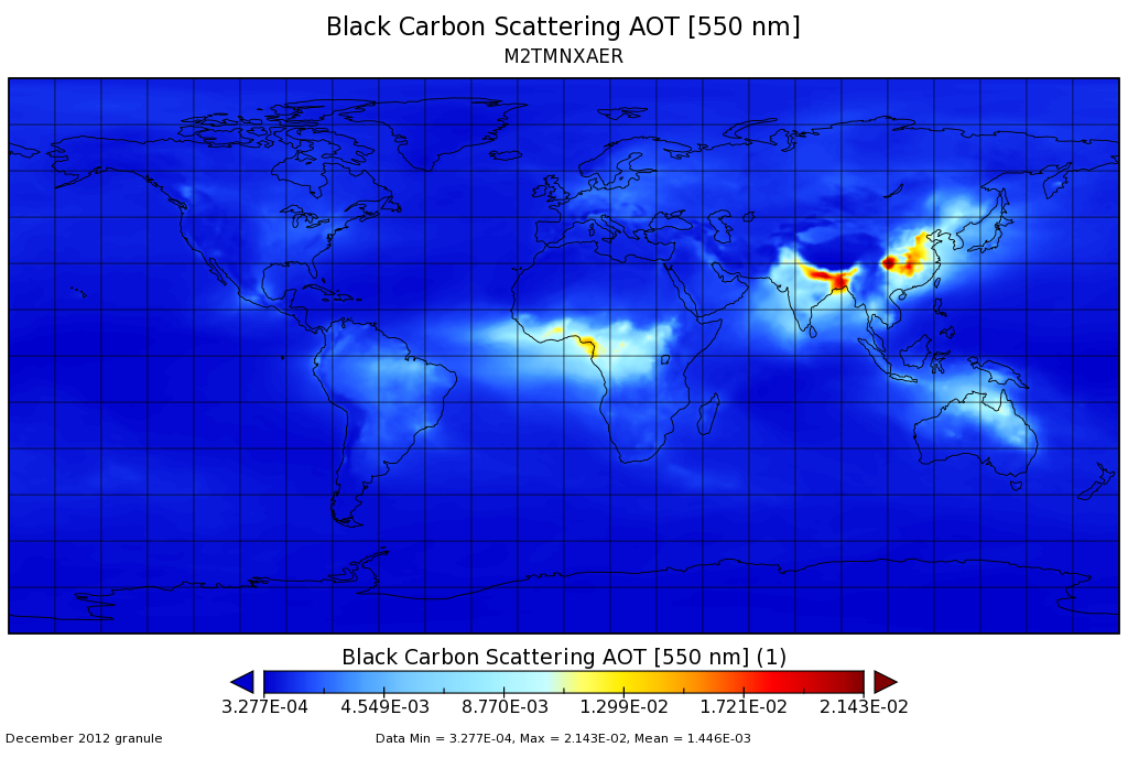
MERRA-2 tavgM_2d_aer_Nx: 2d,Monthly mean,Time-averaged,Single-Level,Assimilation,Aerosol Diagnostics 0.625 x 0.5 degree V5.12.4 (M2TMNXAER) at GES DISC recent views
M2TMNXAER (or tavgM_2d_aer_Nx) is a time-averaged 2-dimensional monthly mean data collection in Modern-Era Retrospective analysis for Research and Applications version 2... -
MERRA-2 tavg1_2d_aer_Nx: 2d,1-Hourly,Time-averaged,Single-Level,Assimilation,Aerosol Diagnostics 0.625 x 0.5 degree V5.12.4 (M2T1NXAER) at GES DISC recent views
M2T1NXAER (or tavg1_2d_aer_Nx) is an hourly time-averaged 2-dimensional data collection in Modern-Era Retrospective analysis for Research and Applications version 2 (MERRA-2).... -
AMSR2/GCOM-W1 surface soil moisture (LPRM) L3 1 day 25 km x 25 km descending V001 (LPRM_AMSR2_D_SOILM3) at GES DISC recent views
AMSR2/GCOM-W1 surface soil moisture (LPRM) L3 1 day 25 km x 25 km descending V001 is a Level 3 (gridded) data set. Its land surface parameters, surface soil moisture, land... -
GLDAS Noah Land Surface Model L4 monthly 1.0 x 1.0 degree V2.1 (GLDAS_NOAH10_M) at GES DISC recent views
NASA Global Land Data Assimilation System Version 2 (GLDAS-2) has three components: GLDAS-2.0, GLDAS-2.1, and GLDAS-2.2. GLDAS-2.0 is forced entirely with the Princeton... -
NCEP/CPC L3 Half Hourly 4km Global (60S - 60N) Merged IR V1 (GPM_MERGIR) at GES DISC recent views
These data originate from NOAA/NCEP. The NOAA Climate Prediction Center/NCEP/NWS is making the data available originally in binary format, in a weekly rotating archive. The NASA... -
GPM IMERG Early Precipitation L3 1 day 0.1 degree x 0.1 degree V06 (GPM_3IMERGDE) at GES DISC recent views
The Integrated Multi-satellitE Retrievals for GPM (IMERG) is the unified U.S. algorithm that provides the multi-satellite precipitation product for the U.S. GPM team. Version 06... -
GPM IMERG Late Precipitation L3 Half Hourly 0.1 degree x 0.1 degree V07 (GPM_3IMERGHHL) at GES DISC recent views
Version 07 is the current version of the data set. Older versions will no longer be available and have been superseded by Version 07. The Integrated Multi-satellitE Retrievals... -
MODIS/Aqua Clouds 1km and 5km 5-Min L2 Wide Swath Subset along CloudSat V002 (MAC06S1) at GES DISC NGDA recent views
This is the wide-swath MODIS/Aqua subset along CloudSat field of view track. The goal of the wide-swath subset is to select and return MODIS data that are within +-100 km across...

Official websites use .gov
A
.gov website belongs to an official government
organization in the United States.
Secure .gov websites use HTTPS
A
lock (
) or https:// means you’ve safely connected to
the .gov website. Share sensitive information only on official,
secure websites.