
-
First ISCCP Regional Experiment (FIRE) Cirrus 1 Surface Radiation Budget (SRB) Data over Alaska recent views
The First ISCCP Regional Experiments have been designed to improve data products and cloud/radiation parameterizations used in general circulation models (GCMs). Specifically,... -
SAGE III/ISS L1B Monthly Solar Event Transmission Data (NetCDF) V052 recent views
g3btmnc_52 is the Stratospheric Aerosol and Gas Experiment III (SAGE III) on the International Space Station (ISS) (SAGE III/ISS) Level 1 Monthly Solar Event Species Profiles... -
SAGE III/ISS L1B Solar Event Transmission Data (Native) V052 recent views
g3btb_52 is the Stratospheric Aerosol and Gas Experiment III (SAGE III) on the International Space Station (ISS) (SAGE III/ISS) Level 1B Solar Event Transmission Data (Native)... -
First ISCCP Regional Experiment (FIRE) Cirrus Phase II National Weather Service(NWS) Outer-Network Rawinsonde Data recent views
The First ISCCP Regional Experiments have been designed to improve data products and cloud/radiation parameterizations used in general circulation models (GCMs). Specifically,... -
TES/Aura L1B Spectra Nadir V006 recent views
TL1BN_6 is the Tropospheric Emission Spectrometer (TES)/Aura L1B Spectra Nadir Version 6 data product. TES was an instrument aboard NASA's Aura satellite and was launched from... -
First ISCCP Regional Experiment (FIRE) Cirrus 1 Surface Radiation Budget (SRB) Data over the South Pole recent views
Results from ISCCP analysis of B3 radiance data (sampled to 25 km). Unlike the standard ISCCP product, these data are reported at original pixel resolution and contain detailed... -
TES/Aura L3 Ozone Monthly Gridded V005 recent views
TL3O3M_5 is the Tropospheric Emission Spectrometer (TES)/Aura Level 3 Ozone (O3) Monthly Gridded Version 5 data product. TES was an instrument aboard NASA's Aura satellite and... -
TES/Aura L3 Atmospheric Temperatures Monthly Gridded V005 recent views
TL3ATM_5 is the Tropospheric Emission Spectrometer (TES)/Aura Level 2 Atmospheric Temperatures Limb Version 5 data product. TES was an instrument aboard NASA's Aura satellite... -
First ISCCP Regional Experiment (FIRE) Cirrus 1 Surface Radiation Budget (SRB) Data over Switzerland recent views
Results from ISCCP analysis of B3 radiance data (sampled to 25 km). Unlike the standard ISCCP product, these data are reported at original pixel resolution and contain detailed... -
TES/Aura L2 H2O Lite Nadir V006 recent views
TL2H2OLN_6 is the Tropospheric Emission Spectrometer (TES)/Aura Level 2 H2O Lite Nadir Version 6 data product. It consists of information for one molecular species for an entire... -
TES/Aura L3 Ozone Daily Gridded V005 recent views
TL3O3D_5 is the Tropospheric Emission Spectrometer (TES)/Aura L3 Ozone Daily Gridded Version 5 data product. TES was an instrument aboard NASA's Aura satellite and was launched... -
Airborne Multi-angle Imaging SpectroRadiometer (AirMISR) Data from the Lunar Lake 2001 Campaign recent views
The AIRMISR_LUNAR_LAKE_2001 data were acquired during a flight over Lunar Lake, Nevada on June 30, 2001. The Jet Propulsion Laboratory (JPL) in Pasadena, California provided the... -
TES/Aura L3 Water Vapor Monthly Gridded V005 recent views
TL3H2OM_5 is the Tropospheric Emission Spectrometer (TES)/Aura Level 3 Water Vapor Monthly Gridded Version 5 data product. TES was an instrument aboard NASA's Aura satellite and... -
SAGE III/ISS L1B Monthly Solar Event Transmission Data (NetCDF) V053 recent views
g3btmnc_53 is the Stratospheric Aerosol and Gas Experiment III (SAGE III) on the International Space Station (ISS) (SAGE III/ISS) Level 1 Monthly Solar Event Species Profiles... -
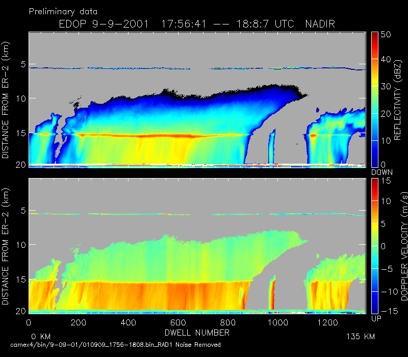
CAMEX-4 ER-2 DOPPLER RADAR V1 recent views
The CAMEX-4 ER-2 Doppler Radar dataset was collected by the ER-2 Doppler radar (EDOP), which is an X-band (9.6 GHz) Doppler radar mounted in the nose of ER-2. The instrument has... -
BOREAS TGB-05 Fire History of Manitoba 1980 to 1991 in Vector Format recent views
Vector format data set covering the province of Manitoba and produced by Forestry Canada from hand-drawn boundaries of fires on photocopies of 1:250,000 scale maps.

Official websites use .gov
A
.gov website belongs to an official government
organization in the United States.
Secure .gov websites use HTTPS
A
lock (
) or https:// means you’ve safely connected to
the .gov website. Share sensitive information only on official,
secure websites.