
-
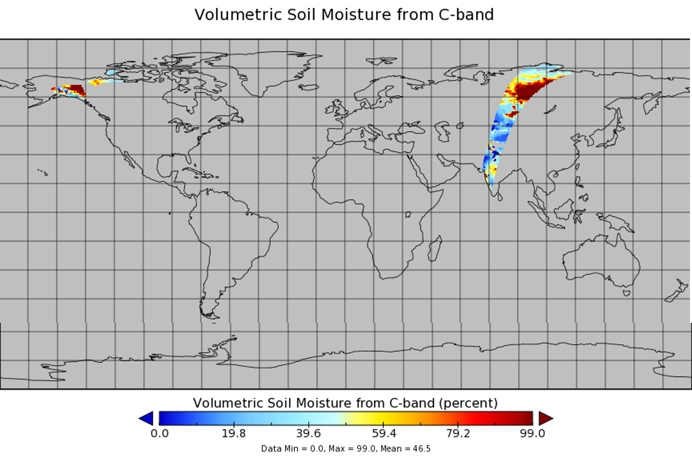
AMSR2/GCOM-W1 surface soil moisture (LPRM) L3 1 day 25 km x 25 km descending V001 (LPRM_AMSR2_D_SOILM3) at GES DISC recent views
AMSR2/GCOM-W1 surface soil moisture (LPRM) L3 1 day 25 km x 25 km descending V001 is a Level 3 (gridded) data set. Its land surface parameters, surface soil moisture, land... -
VEMAP 2: Annual Ecosystem Model Responses to U.S. Climate Change, 1994-2100 recent views
Phase 2 of the VEMAP Project developed historical (1895-1993) gridded data sets of climate (temperature, precipitation, solar radiation, humidity, and wind speed) and projected... -
NACP Regional: National Greenhouse Gas Inventories and Aggregated Gridded Model Data recent views
This data set provides two products that were derived from the recently published North American Carbon Program (NACP) Regional Synthesis 1-degree terrestrial biosphere model... -
AMSR2/GCOM-W1 surface soil moisture (LPRM) L3 1 day 10 km x 10 km ascending V001 (LPRM_AMSR2_DS_A_SOILM3) at GES DISC recent views
AMSR2/GCOM-W1 surface soil moisture (LPRM) L3 1 day 10 km x 10 km ascending V001 is a Level 3 (gridded) data set. Its land surface parameters, surface soil moisture, land... -
TMI/TRMM surface soil moisture (LPRM) L2 V001 (LPRM_TMI_SOILM2) at GES DISC recent views
TMI/TRMM surface soil moisture (LPRM) L2 V001 is a Level 2 (swath) data set. Its land surface parameters, surface soil moisture, land surface (skin) temperature, and vegetation... -
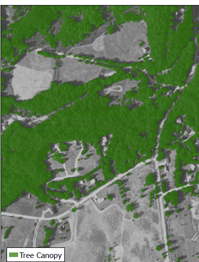
NACP Integrated Wildland and Cropland 30-m Fuel Characteristics Map, U.S.A., 2010 recent views
The data set provides a 30-m comprehensive fuelbed characteristics map for both the wildland and cropland areas of the conterminous United States (CONUS) for 2010. This... -
Forest Inventory and Biophysical Measurements, Brazilian Amazon, 2009-2018 recent views
This dataset provides the complete catalog of forest inventory and biophysical measurements collected over selected forest research sites across the Amazon rainforest in Brazil... -
NLDAS Noah Land Surface Model L4 Monthly 0.125 x 0.125 degree V2.0 (NLDAS_NOAH0125_M) at GES DISC recent views
This data set contains fifty-two fields simulated from the Noah land-surface model (LSM) for Phase 2 of the North American Land Data Assimilation System (NLDAS-2). The data are... -
Siberian Boreal Forest Aboveground Biomass and Fire Scar Maps, Russia, 1969-2007 NGDA recent views
This data set provides 30-meter resolution mapped estimates of Cajander larch (Larix cajanderi) aboveground biomass (AGB), circa 2007, and a map of burn perimeters for 116... -
Global Forest Ecosystem Structure and Function Data For Carbon Balance Research recent views
A comprehensive global database has been assembled to quantify CO2 fluxes and pathways across different levels of integration (from photosynthesis up to net ecosystem... -
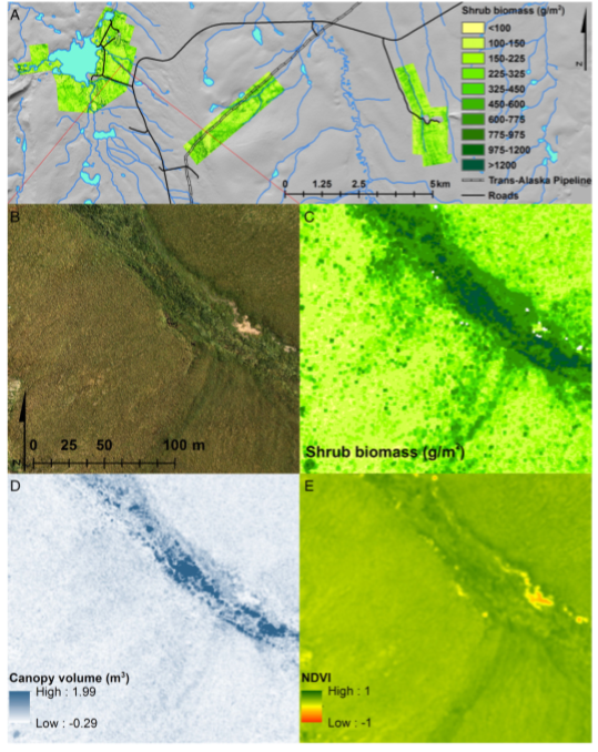
High-Resolution Shrub Biomass and Uncertainty Maps, Toolik Lake Area, Alaska, 2013 recent views
This dataset contains estimates for aboveground shrub biomass and uncertainty at high spatial resolution (0.80-m) across three research areas near Toolik Lake, Alaska. The... -
WindSat/Coriolis surface soil moisture (LPRM) L2 V001 (LPRM_WINDSAT_SOILM2) at GES DISC recent views
WindSat/Coriolis surface soil moisture (LPRM) L2 V001 is a Level 2 (swath) data set. Its land surface parameters, surface soil moisture, land surface (skin) temperature, and... -
ABoVE: Needle-Level Chlorophyll Fluorescence, Alaska and Idaho, USA, 2017 and 2019 recent views
This dataset provides the results of in situ measurements of needle-level chlorophyll fluorescence (ChlF) obtained from a pulse amplitude modulated (PAM) fluorometer from... -
Arctic Vegetation Plots for IBP Tundra Biome, Barrow, Alaska, 1972-2010 recent views
This data set provides vegetation cover and environmental plot data collected as part of the International Biological Program (IBP), U. S. Tundra Biome Program, in Barrow,... -
Arctic Vegetation Plots at Toolik Lake, Alaska, 1989 recent views
This dataset provides environmental, soil, and vegetation data collected in August 1989 from 81 study plots at the Toolik Lake research site, located in the southern Arctic... -
LBA-ECO TG-07 Ground-based Biometry Data at km 83 Site, Tapajos National Forest: 1997 recent views
A field inventory of trees was conducted in March of 1997 in a logging concession at the Tapajos National Forest, south of Santarem, Para, Brazil. The inventory was conducted by... -
BigFoot Field Data for North American Sites, 1999-2003 recent views
The BigFoot project gathered field data for selected EOS Land Validation Sites in North America from 1999 to 2003. Data collected and derived for varying intervals at the... -
CMS: LiDAR-derived Biomass, Canopy Height and Cover, Sonoma County, California, 2013 recent views
This data set provides estimates of above-ground biomass (AGB), canopy height, and percent tree cover at 30-m spatial resolution for Sonoma County, California, USA, for the... -
ABoVE: Photochemical Reflectance and Tree Growth, Brooks Range, Alaska, 2018-2019 recent views
This dataset provides simultaneous in-situ measurements of the photochemical reflectance index (PRI) and radial tree growth of selected white spruce trees (Picea glauca (Moench)...

Official websites use .gov
A
.gov website belongs to an official government
organization in the United States.
Secure .gov websites use HTTPS
A
lock (
) or https:// means you’ve safely connected to
the .gov website. Share sensitive information only on official,
secure websites.