
-
MODIS/Terra Aerosol 5-Min L2 Swath 3km NGDA recent views
The new Collection 6.1 (C61) MODIS/Terra Aerosol 5 Min L2 Swath 3km (MOD04_3K) product is an improved version based on algorithm changes in Dark Target (DT) Aerosol retrieval... -
MODIS/Terra Cloud Mask and Spectral Test Results 5-Min L2 Swath 250m and 1km NGDA recent views
The MODIS/Terra Cloud Mask and Spectral Test Results 5-Min L2 Swath 250m and 1km product consists of global cloud mask quality assurance and other ancillary parameters. The... -
VIIRS/JPSS1 Day/Night Band 6-Min L1B Swath 750 m recent views
The VIIRS/JPSS1 Day/Night Band 6-Min L1B Swath 750 m, short-name VJ102DNB is platform-derived single NASA VIIRS panchromatic Day-Night band (DNB) calibrated radiance product.... -
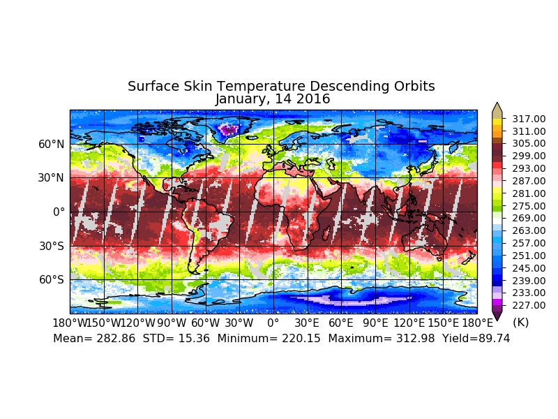
NOAA-18 AVHRR Atmospherically Corrected Surface Reflectance Daily L3 Global 0.05 Deg. CMG recent views
The Long-Term Data Record (LTDR) produces, validates, and distributes a global land surface climate data record (CDR) that uses both mature and well-tested algorithms in concert... -
Sounder SIPS: Suomi NPP CrIMSS Level 3 Comprehensive Quality Control Gridded Monthly CLIMCAPS Full Spectral Resolution V2 at GES DISC recent views
WARNING: To users of the derived product “co_mmr_midtrop” (carbon monoxide mass mixing ratio to dry air [kg/kg] at ~500 hPa). This variable has a significant bias due to a... -
ASTER Expedited L1A Reconstructed Unprocessed Instrument Data V003 NGDA recent views
The Advanced Spaceborne Thermal Emission and Reflection Radiometer (ASTER) Expedited Level 1A Reconstructed Unprocessed Instrument Data (AST_L1AE) product contains... -
VIIRS/JPSS1 Moderate Resolution Terrain Corrected Geolocation L1 6-Min Swath 750m recent views
The VIIRS/JPSS1 Moderate Resolution Terrain Corrected Geolocation 6-Min L1 Swath 750m product, short-name VJ103MOD contains the derived line-of-sight (LOS) vectors for each of... -
METOP-B AVHRR Atmospherically Corrected Surface Reflectance Daily L3 Global 0.05 Deg CMG recent views
The Long-Term Data Record (LTDR) produces, validates, and distributes a global land surface climate data record (CDR) that uses both mature and well-tested algorithms in concert... -
VIIRS/NPP BRDF/Albedo Model Parameters Daily L3 Global 1km SIN Grid V001 recent views
The NASA/NOAA Suomi National Polar-orbiting Partnership (Suomi NPP) Visible Infrared Imaging Radiometer Suite (VIIRS) Bidirectional Reflectance Distribution Function (BRDF) and... -
Sounder SIPS: Suomi NPP CrIMSS Level 3 Specific Quality Control Gridded Daily CHART Normal Spectral Resolution V1 recent views
The objective of this limited edition data collection is to examine products generated by the Climate Heritage AIRS Retrieval Technique (CHART) algorithm to analyze Cross-track... -
VIIRS/JPSS1 Moderate Resolution 6-Min L1B Swath 750m NRT recent views
The VIIRS Level 1 and Level 2 swath products are generated from the processing of 6 minutes of VIIRS data acquired during the JPSS1 satellite overpass. The VIIRS sensor has 16... -
Sounder SIPS: Suomi NPP CrIMSS Level 3 Specific Quality Control Gridded Daily CLIMCAPS Full Spectral Resolution V2 at GES DISC recent views
WARNING: To users of the derived product “co_mmr_midtrop” (carbon monoxide mass mixing ratio to dry air [kg/kg] at ~500 hPa). This variable has a significant bias due to a... -
Rongowai-CYGNSS Airborne Level 1 Science Data Record Version 1.0 recent views
The Rongowai Level 1 Science Data Record Version 1.0 dataset is generated by the University of Auckland (UoA) Rongowai Science Payloads Operations Centre in New Zealand. This... -
Sounder SIPS: Suomi NPP CrIMSS Level 3 Comprehensive Quality Control Gridded Daily CHART Normal Spectral Resolution V1 recent views
The objective of this limited edition data collection is to examine products generated by the Climate Heritage AIRS Retrieval Technique (CHART) algorithm to analyze Cross-track...

Official websites use .gov
A
.gov website belongs to an official government
organization in the United States.
Secure .gov websites use HTTPS
A
lock (
) or https:// means you’ve safely connected to
the .gov website. Share sensitive information only on official,
secure websites.