
-
BOREAS Landsat TM Level-3p Imagery: Geocoded and Scaled At-Sensor Radiance recent views
For BOREAS, the level-3p Landsat TM data were used to supplement the level-3s Landsat TM products. Along with the other remotely sensed images, the Landsat TM images were... -
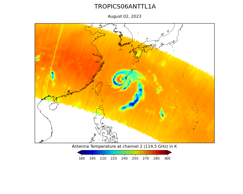
TROPICS03 L2B Atmospheric Vertical Temperature and Moisture Profiles (AVTP, AVMP) V0.2 recent views
The "Time-Resolved Observations of Precipitation structure and storm Intensity with a Constellation of Smallsats" (TROPICS) mission has a goal of providing nearly all-weather... -
BOREAS SERM Forest Cover Data of Saskatchewan in Vector Format recent views
A condensed forest cover type digital map of Saskatchewan and is a product of the Saskatchewan Environment and Resource Management, Forestry Branch-Inventory Unit (SERM-FBIU).... -
BOREAS RSS-15 SIR-C and TM Biomass and Landcover Maps of the NSA and SSA recent views
The RSS-15 team conducted an investigation using SIR-C , X-SAR and Landsat TM data for estimating total above-ground dry biomass for the SSA and NSA modeling grids and component... -
BOREAS RSS-10 TOMS Circumpolar One-Degree PAR Images recent views
The BOREAS RSS-10 team investigated the magnitude of daily, seasonal, and yearly variations of PAR from ground and satellite observations. This data set contains satellite... -
BOREAS RSS-14 GOES-8 Level-1 Visible, Infrared and Water Vapor Images recent views
The level-1 BOREAS GOES-8 images are raw data values collected by RSS-14 personnel at FSU and delivered to BORIS. The data cover 14-Jul-1995 to 21-Sep-1995 and 01-Jan-1996 to... -
BOREAS RSS-19 1994 CASI At-Sensor Radiance and Reflectance Images recent views
CASI images from the Chieftain Navaho aircraft taken in order to observe the seasonal change in the radiometric reflectance properties of the boreal forest landscape. CASI data... -
BOREAS Level-0 AOCI Imagery: Digital Counts in BIL Format recent views
The level-0 AOCI imagery, along with the other remotely sensed images, was collected to provide spatially extensive information about radiant energy over the primary BOREAS... -
BOREAS AFM-06 NOAA/ETL 35 GHz Cloud/Turbulence Radar GIF Images recent views
The BOREAS AFM-06 team from the National Oceanic and Atmospheric Administration Environmental Technology Laboratory (NOAA/ETL) operated a 35 GHz cloud-sensing radar in the... -
BOREAS TE-18 Landsat TM Maximum Likelihood Classification Image of the NSA recent views
The objective of this classification is to provide the BOREAS investigators with a data product that characterizes the land cover of the NSA. A Landsat-5 TM image from... -
BOREAS RSS-17 1994 ERS-1 Level-3 Freeze/Thaw Backscatter Change Images recent views
The BOREAS RSS-17 team acquired and analyzed imaging radar data from the ESA's ERS-1 over a complete annual cycle at the BOREAS sites in Canada in 1994 to detect shifts in radar... -
BOREAS RSS-14 GOES-8 Level-1a Visible, Infrared and Water Vapor Images recent views
The level-1a GOES-8 images cover 14-Jul-1995 to 21-Sep-1995 and 12-Feb-1996 to 03-Oct-1996. The data start out as three bands with 8-bit pixel values and end up as five bands... -
BOREAS TE-18 Landsat TM Physical Classification Image of the SSA recent views
The objective of this classification is to provide BOREAS investigators with a data product that characterizes the land cover of the SSA. A Landsat-5 TM image from 02-Sep-1994... -
BOREAS Level-0 TIMS Imagery: Digital Counts in BIL Format recent views
The TIMS imagery, along with the other remotely sensed images, was collected to provide spatially extensive information over the primary study areas. This information includes... -
BOREAS RSS-16 AIRSAR CM V6.1 Images recent views
Satellite and aircraft SAR data used in conjunction with ground measurements to determine the moisture regime of the boreal forest. The NASA JPL AIRSAR is a side-looking imaging... -
BOREAS RSS-14 GOES-7 Level-2 Shortwave and Longwave Radiation Images recent views
This data set contains images of shortwave and longwave radiation at the surface and top of the atmosphere derived from collected GOES-7 data. The data cover the time period of... -
SAFARI 2000 Freshwater Wetlands, 1-Deg (Stillwell-Soller et al.) recent views
This data set consists of a southern Africa subset of the Global Distribution of Freshwater Wetlands database 1-degree data and is available in ASCII GRID and binary image file... -
TROPICS07 L1B Orbital Geolocated Native-Resolution Brightness Temperatures V0.2 recent views
The "Time-Resolved Observations of Precipitation structure and storm Intensity with a Constellation of Smallsats" (TROPICS) mission has a goal of providing nearly all-weather... -
TROPICS07 L1A Orbital Geolocated Native-Resolution Antenna Temperatures V0.2 recent views
The "Time-Resolved Observations of Precipitation structure and storm Intensity with a Constellation of Smallsats" (TROPICS) mission has a goal of providing nearly all-weather... -
TROPICS03 L1B Orbital Geolocated Native-Resolution Brightness Temperatures V1.0 recent views
The "Time-Resolved Observations of Precipitation structure and storm Intensity with a Constellation of Smallsats" (TROPICS) mission has a goal of providing nearly all-weather...

Official websites use .gov
A
.gov website belongs to an official government
organization in the United States.
Secure .gov websites use HTTPS
A
lock (
) or https:// means you’ve safely connected to
the .gov website. Share sensitive information only on official,
secure websites.