
-
Global Land Cover Characterization Program recent views
The Global Land Cover Characterization Project was established to meet science data requirements identified by the International Geosphere and Biosphere Programme (IGBP), and... -
USGS Digital Orthophoto Quadrangles recent views
A Digital Orthophoto Quadrangle (DOQ) is a computer-generated image of an aerial photograph in which the image displacement caused by terrain relief and camera tilt has been... -
SENTINEL-1B_SINGLE_POL_GRD_HIGH_RES recent views
Sentinel-1B Single-pol ground projected high and full resolution images -
Delta-X: AirSWOT L2 Geocoded Water Surface Elevation, MRD, Louisiana, 2021, Version 2 recent views
This dataset contains Level 2 (L2) AirSWOT geocoded products, including estimated water surface elevation. The AirSWOT instrument is a Ka-band interferometer and for this study... -
Aerial Photographs (from AMES Pilot Land Data System); USGS EDC, Sioux Falls recent views
The aerial photography inventoried by the Pilot Land Data System (PLDS) at NASA AMES Research Center has been transferred to the USGS EROS Data Center. The photos were obtained... -
Global Soil Profile Data (ISRIC-WISE) recent views
The ISRIC-WISE International soil profile data set consists of a homogenized, global set of 1,125 soil profiles for use by global modelers. These profiles provided the basis for... -
SENTINEL-1B_DUAL_POL_GRD_MEDIUM_RES recent views
Sentinel-1B Dual-pol ground projected medium resolution images -
Delta-X: UAVSAR L1 Single Look Complex (SLC) Stack Products, MRD, Louisiana, 2021 recent views
This dataset contains UAVSAR Level 1 (L1) Single Look Complex (SLC) stack products for Delta-X flight lines acquired during 2021-03-27 to 2021-04-18 (spring) and 2021-09-03 to... -
Arctic Vegetation Plots in Northern NWT and YT, Canada, 1965-1966 recent views
This dataset provides vegetation, soil, and plot characteristics for 154 study plots located at three sites across the Richardson Mountains, Northwest Territories (NWT), and the... -
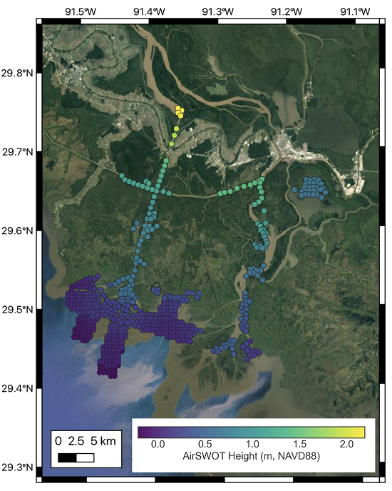
Delta-X: AirSWOT L3 Water Surface Elevations, MRD, Louisiana, 2021 recent views
This dataset contains water surface elevations at selected point locations generated from the AirSWOT data collected during the Spring and Fall 2021 Delta-X deployments over the... -
SENTINEL-1A_SINGLE_POL_GRD_MEDIUM_RES recent views
Sentinel-1A Single-pol ground projected medium resolution images -
SENTINEL-1B_DUAL_POL_GRD_HIGH_RES recent views
Sentinel-1B Dual-pol ground projected high and full resolution images -
SENTINEL-1B_SINGLE_POL_GRD_MEDIUM_RES recent views
Sentinel-1B Single-pol ground projected medium resolution images

Official websites use .gov
A
.gov website belongs to an official government
organization in the United States.
Secure .gov websites use HTTPS
A
lock (
) or https:// means you’ve safely connected to
the .gov website. Share sensitive information only on official,
secure websites.