
-
Shuttle Radar Topography Mission DTED Level 1 (3-arc second) Data (DTED-1) recent views
The Shuttle Radar Topography Mission (SRTM) successfully collected Interferometric Synthetic Aperture Radar (IFSAR) data over 80 percent of the landmass of the Earth between 60... -
Shuttle Radar Topography Mission 1-arc second Global recent views
The Shuttle Radar Topography Mission (SRTM) was flown aboard the space shuttle Endeavour February 11-22, 2000. The National Aeronautics and Space Administration (NASA) and the... -
Shuttle Radar Topography Mission (SRTM) Version 2 recent views
NASA has released version 2 of the Shuttle Radar Topography Mission digital topographic data (also known as the "finished" version). Version 2 is the result of a substantial... -
SMAP_L1B_SIGMA_NAUGHT_LOW_RES_QA_V002 recent views
SMAP Level 1B Sigma Naught Low Res Data Quality Info Version 2 -
SMAP_L1A_RADAR_RECEIVE_ONLY_QA_V003 recent views
SMAP Level 1A Radar Receive Only Data Quality Information Version 3 -
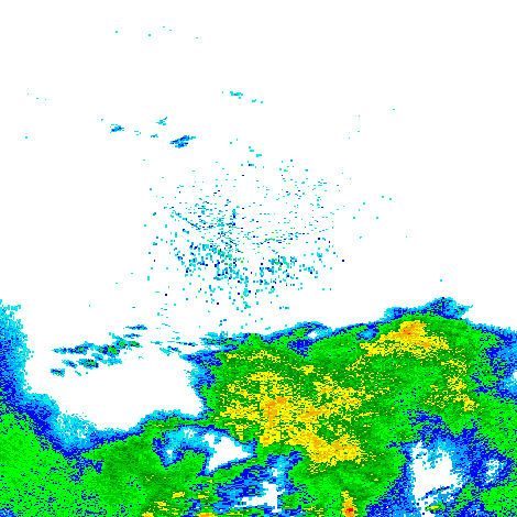
Shuttle Radar Topography Mission (SRTM) Images recent views
Culminating more than four years of processing data, NASA and the National Geospatial-Intelligence Agency (NGA) have completed Earth's most extensive global topographic map. The... -
CYGNSS Level 1 Raw Intermediate Frequency Data Record recent views
This Level 1 (L1) dataset contains the Raw Intermediate Frequency (IF) sensor data from the Delay Doppler Mapping Instrument aboard the CYGNSS satellite constellation. The... -
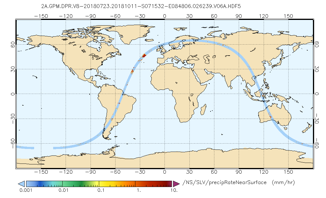
GPM DPR Precipitation Profile L2A 1.5 hours 5 km V07 (GPM_2ADPR) at GES DISC recent views
Version 07 is the current version of the data set. Older versions will no longer be available and have been superseded by Version 07. . 2ADPR provides single- and dual-... -
SMEX02 Passive and Active L and S band System (PALS) Data, Version 1 recent views
This data set contains calibrated sensor measurements acquired by the Passive and Active L- and S-band (PALS) airborne microwave sensor during the Soil Moisture Experiment 2002... -
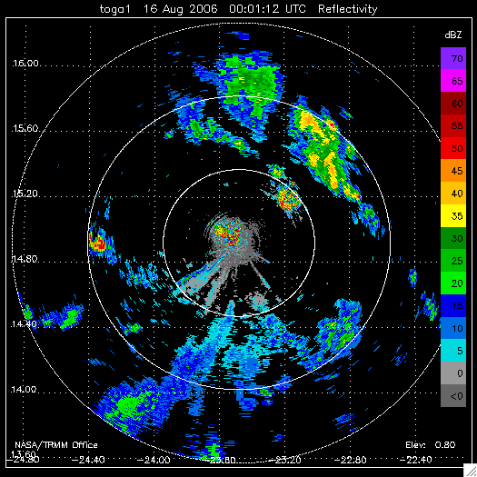
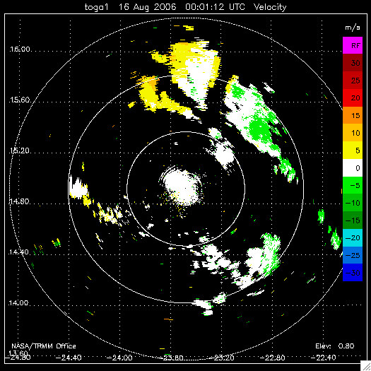
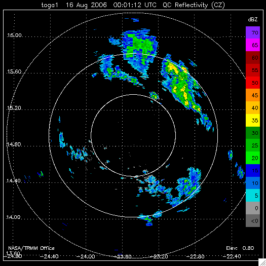
NAMMA TOGA RADAR DATA V1 recent views
The NAMMA TOGA Radar Data dataset consists of a collection of products derived from the NASA TOGA radar observations that were collected in the Republic of Cape Verde during the... -
GPM GROUND VALIDATION NASA MICRO RAIN RADAR (MRR) MC3E V1 recent views
The GPM Ground Validation NASA Micro Rain Radar (MRR) MC3E dataset was collected by a Micro Rain Radar (MRR), which is a vertically pointing Doppler radar which provides... -
GPM GROUND VALIDATION NEXRAD LEVEL II KARX IFLOODS V1 recent views
The GPM Ground Validation Next Generation Weather Radar (NEXRAD) Level II IFloodS datasets were collected from four sites (see Table 1) from March 29, 2013 to June 18, 2013 for... -
GPM Ground Validation KHTX NEXRAD IPHEx V1 recent views
The GPM Ground Validation KHTX NEXRAD IPHEx datasets contain data from the KHTX NEXt Generation Weather RADar system (NEXRAD) instrument in operation during the Integrated... -
SMEX03 QuikSCAT/SeaWinds Backscatter Data, Brazil, Version 1 recent views
This data set includes data collected over the Soil Moisture Experiment 2003 (SMEX03) areas of Alabama, Georgia, Oklahoma, USA , and Brazil. -
UC Berkeley CYGNSS Level 3 Monthly RWAWC Watermask Version 3.1 recent views
The CYGNSS Level 3 UC Berkeley Watermask Record Version 3.1 was developed by CYGNSS investigators in the Department of Civil and Environmental Engineering at the University of... -
CYGNSS Level 1 Science Data Record Version 3.2 recent views
This CYGNSS Level 1 (L1) science data record dataset contains the version 3.2 geo-located Delay Doppler Maps (DDMs) calibrated into Power Received (Watts) and Bistatic Radar... -
NEXRAD Mosaic Midwest IMPACTS V1 recent views
The NEXRAD Mosaic Midwest IMPACTS dataset consists of Next Generation Weather Radar (NEXRAD) 3D mosaic files created from Level II surveillance data gathered during the...

Official websites use .gov
A
.gov website belongs to an official government
organization in the United States.
Secure .gov websites use HTTPS
A
lock (
) or https:// means you’ve safely connected to
the .gov website. Share sensitive information only on official,
secure websites.