
-
MODIS-derived Annual Vegetation Resilience, 2000-2019 NGDA recent views
This dataset provides estimates of vegetation resilience in the Arctic Boreal Vulnerability Experiment (ABoVE) core domain at annual time steps for 2000-2019 and at 300-m... -
BigFoot Field Data for North American Sites, 1999-2003 recent views
The BigFoot project gathered field data for selected EOS Land Validation Sites in North America from 1999 to 2003. Data collected and derived for varying intervals at the... -
SAGE III/ISS L2 Lunar Event Species Profiles (Native) V053 recent views
g3blspb_53 is the Stratospheric Aerosol and Gas Experiment III (SAGE III) on the International Space Station (ISS) (SAGE III/ISS) Level 2 Lunar Event Species Profiles (Native)... -
SAGE III/ISS L2 Monthly Aerosol Product (NetCDF) V011 recent views
Data quality notice: The SAGE III/ISS team recommends against using data from events 2024030913SS, 2024030915SS, and 2024030917SS. These events were affected by line-of-sight... -
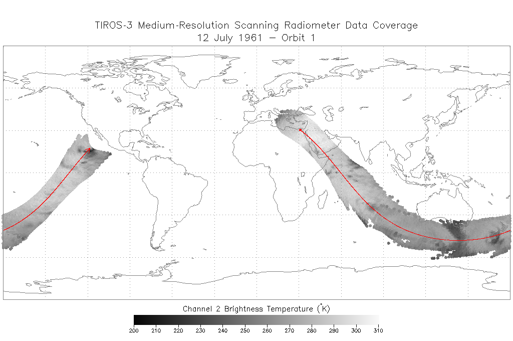
TIROS-3 Medium-Resolution Scanning Radiometer Level 1 Final Meteorological Radiation Data V001 (TIROS3L1FMRT) at GES DISC recent views
TIROS-3 Medium-Resolution Scanning Radiometer Level 1 Final Meteorological Radiation Data (FMRT) product contains radiances expressed in five infrared/visible wavelength... -
Impacts of Wildfires on Boreal Forest Ecosystem Carbon Dynamics recent views
This dataset contains simulations of net primary production (NPP), heterotrophic respiration (RH), net ecosystem production (NEP), and soil temperature data in North American... -
SAGE III/ISS L2 Monthly Aerosol Product (NetCDF) V001 recent views
Data quality notice: The SAGE III/ISS team recommends against using data from events 2024030913SS, 2024030915SS, and 2024030917SS. These events were affected by line-of-sight... -
Aquarius Official Release Level 3 Sea Surface Density Standard Mapped Image Descending Daily Data V5.0 recent views
Aquarius Level 3 sea surface density standard mapped image data contains gridded 1 degree spatial resolution density data averaged over daily, 7 day, monthly, and seasonal time... -
Aboveground Biomass from SAR, Great Slave Lake Region, NWT, 2019 recent views
This dataset holds aboveground biomass (ABG) estimates for areas in the Great Slave Lake Region in the Northwest Territories of Canada for 2019. ABG was estimated from L-band... -
Aquarius Official Release Level 3 Rain-flagged Sea Surface Salinity Standard Mapped Image Seasonal Data V5.0 recent views
Aquarius Level 3 sea surface salinity (SSS) rain-flagged standard mapped image data contains gridded 1 degree spatial resolution SSS averaged over daily, 7 day, monthly, and... -
NARSTO Pacific 2001 Air Quality Study (PAC2001) Greater Vancouver Regional District (GVRD) and and Canadian Air and Precipitation Monitoring Network (CAPMoN) Supplemental Air Quality Data recent views
NARSTO_PAC2001_GVRD_CAPMON_AIR_QUAL_DATA is the North American Research Strategy for Tropospheric Ozone (NARSTO) Pacific 2001 Air Quality Study (PAC2001) Greater Vancouver... -
CERES A-Train Integrated CALIPSO, CloudSat, CERES, and MODIS (CCCM) Merged Release B1 NGDA recent views
CER-NEWS_CCCM_Aqua-FM3-MODIS-CAL-CS_RelB1 is the Clouds and the Earth's Radiant Energy System (CERES) NASA Energy and Water cycle Study (NEWS) A-Train Integrated Cloud-Aerosol... -
Annual Land Use and Urban Land Cover: Ethiopia, Nigeria, and South Africa, 2016-2020 recent views
This dataset provides a two-tier annual Land Use (LU) and Urban Land Cover (LC) product suite over three African countries, Ethiopia, Nigeria, and South Africa, across a 5-year... -
Delta-X AVIRIS-NG L3 Derived Vegetation Types, MRD, Louisiana, USA recent views
This dataset provides maps of vegetation types for the Atchafalaya and Terrebonne basins in coastal Louisiana, U.S., derived from NASA's Next Generation Airborne Visible... -
Aquarius Official Release Level 3 Sea Surface Salinity Standard Mapped Image Daily Data V5.0 recent views
Aquarius Level 3 sea surface salinity (SSS) standard mapped image data contains gridded 1 degree spatial resolution SSS averaged over daily, 7 day, monthly, and seasonal time... -
LBA-ECO CD-34 Hyperion 30-m Surface Reflectance, Amazon Basin: 2002-2005 recent views
This data set contains 20 multispectral surface reflectance images collected by the EO-1 satellite Hyperion sensor at 30-m resolution and covering the entire Amazon Basin for... -
Aquarius Official Release Level 3 Sea Surface Density Standard Mapped Image Mission Cumulative Data V5.0 recent views
Aquarius Level 3 sea surface density standard mapped image data contains gridded 1 degree spatial resolution derived density averaged over daily, 7 day, monthly, and seasonal... -
Aquarius Official Release Level 3 Sea Surface Density Standard Mapped Image Annual Data V5.0 recent views
Aquarius Level 3 sea surface density standard mapped image data contains gridded 1 degree spatial resolution SSS averaged over daily, 7 day, monthly, and seasonal time scales.... -
NARSTO Pacific 2001 Air Quality Study (PAC2001) Golden Ears Gaseous and Particulate Matter (PM) Data recent views
NARSTO_PAC2001_GOLDEN_EARS_GAS_PM_DATA is the North American Research Strategy for Tropospheric Ozone (NARSTO) Pacific 2001 Air Quality Study (PAC2001) Golden Ears Gaseous,... -
ACT-America: Gridded Ensembles of Surface Biogenic Carbon Fluxes, 2003-2019 recent views
This data set provides gridded, model-derived gross primary productivity (GPP), ecosystem respiration (RECO), and net ecosystem exchange (NEE) of CO2 biogenic fluxes and their...

Official websites use .gov
A
.gov website belongs to an official government
organization in the United States.
Secure .gov websites use HTTPS
A
lock (
) or https:// means you’ve safely connected to
the .gov website. Share sensitive information only on official,
secure websites.