
-
National Agriculture Imagery Program (NAIP) recent views
The National Agriculture Imagery Program (NAIP) acquires aerial imagery during the agricultural growing seasons in the continental U.S. A primary goal of the NAIP program is to... -
NACP North American Forest Dynamics Project: Forest Disturbance and Regrowth Data recent views
This data set provides the results of time-series analyses of Landsat imagery for 55 selected forested sites across the conterminous U.S.A. The output is a pair of disturbance... -
TRMM (TMPA) Rainfall Estimate L3 3 hour 0.25 degree x 0.25 degree V7 (TRMM_3B42) at GES DISC recent views
TMPA (3B42) dataset have been discontinued as of Dec. 31, 2019, and users are strongly encouraged to shift to the successor IMERG dataset (doi: 10.5067/GPM/IMERG/3B-HH/06). This... -
GLDAS Noah Land Surface Model L4 monthly 0.25 x 0.25 degree V2.1 (GLDAS_NOAH025_M) at GES DISC recent views
NASA Global Land Data Assimilation System Version 2 (GLDAS-2) has three components: GLDAS-2.0, GLDAS-2.1, and GLDAS-2.2. GLDAS-2.0 is forced entirely with the Princeton... -
ASTER Global Digital Elevation Model V003 NGDA recent views
The ASTER Global Digital Elevation Model (GDEM) Version 3 (ASTGTM) provides a global digital elevation model (DEM) of land areas on Earth at a spatial resolution of 1 arc second... -
VEMAP 2: Annual Ecosystem Model Responses to U.S. Climate Change, 1994-2100 recent views
Phase 2 of the VEMAP Project developed historical (1895-1993) gridded data sets of climate (temperature, precipitation, solar radiation, humidity, and wind speed) and projected... -
GPM IMERG Final Precipitation L3 Half Hourly 0.1 degree x 0.1 degree V07 (GPM_3IMERGHH) at GES DISC recent views
Version 07 is the current version of the data set. Older versions will no longer be available and have been superseded by Version 07. The Integrated Multi-satellitE Retrievals... -
Ocean Surface Current Analyses Real-time (OSCAR) Surface Currents - Final 0.25 Degree (Version 2.0) recent views
Ocean Surface Current Analyses Real-time (OSCAR) is a global surface current database and NASA funded research project. OSCAR ocean mixed layer velocities are calculated from... -
ASTER Digital Elevation Model V003 NGDA recent views
The ASTER Digital Elevation Model (AST14DEM) product is generated (https://lpdaac.usgs.gov/documents/996/ASTER_Earthdata_Search_Order_Instructions.pdf) using bands 3N (nadir-... -
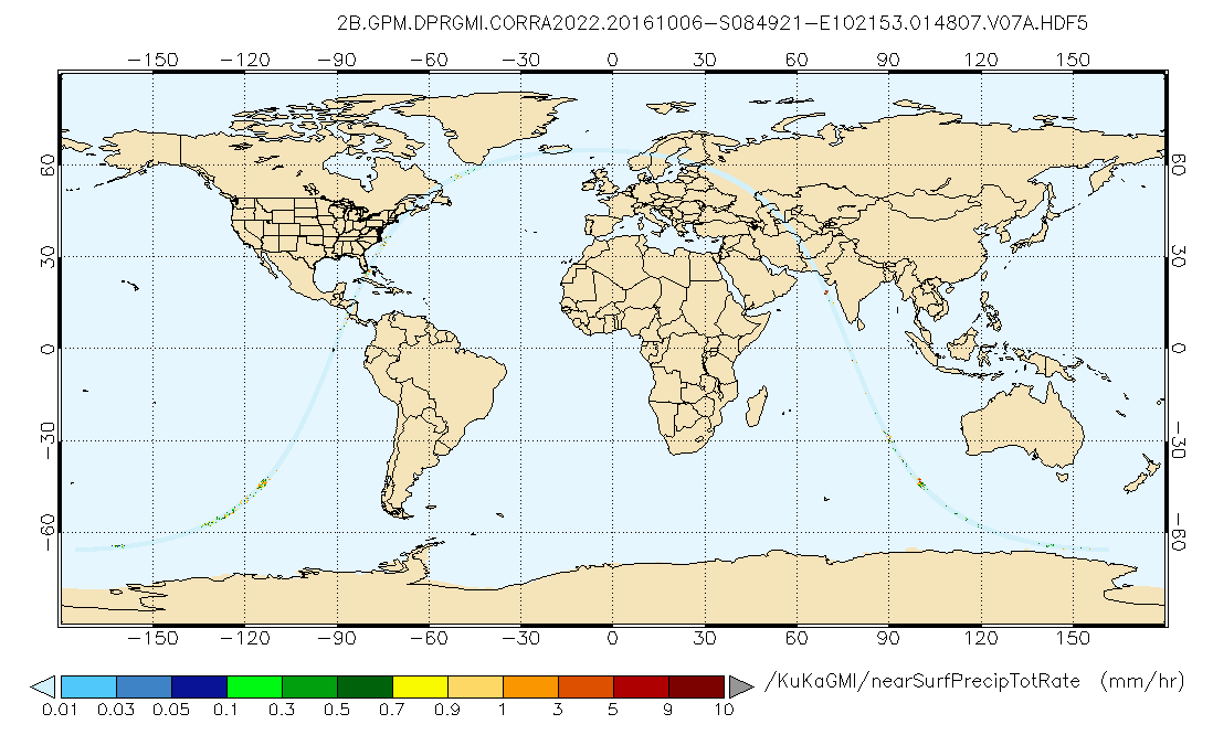
GPM DPR and GMI Combined Precipitation L2B 1.5 hours 5 km V07 (GPM_2BCMB) at GES DISC recent views
Version 07 is the current version of the data set. Older versions will no longer be available and have been superseded by Version 07. This is a precipitation product created... -
MERRA-2 tavg1_2d_aer_Nx: 2d,1-Hourly,Time-averaged,Single-Level,Assimilation,Aerosol Diagnostics 0.625 x 0.5 degree V5.12.4 (M2T1NXAER) at GES DISC recent views
M2T1NXAER (or tavg1_2d_aer_Nx) is an hourly time-averaged 2-dimensional data collection in Modern-Era Retrospective analysis for Research and Applications version 2 (MERRA-2).... -
GPM IMERG Final Precipitation L3 1 month 0.1 degree x 0.1 degree V07 (GPM_3IMERGM) at GES DISC recent views
Version 07 is the current version of the data set. Older versions will no longer be available and have been superseded by Version 07. The Integrated Multi-satellitE Retrievals... -
Global Vegetation Greenness (NDVI) from AVHRR GIMMS-3G+, 1981-2022 recent views
This dataset holds the Global Inventory Modeling and Mapping Studies-3rd Generation V1.2 (GIMMS-3G+) data for the Normalized Difference Vegetation Index (NDVI). NDVI was based... -
GLDAS Catchment Land Surface Model L4 daily 0.25 x 0.25 degree GRACE-DA1 V2.2 (GLDAS_CLSM025_DA1_D) at GES DISC recent views
NASA Global Land Data Assimilation System Version 2 (GLDAS-2) has three components: GLDAS-2.0, GLDAS-2.1, and GLDAS-2.2. GLDAS-2.0 is forced entirely with the Princeton... -
MODIS/Terra Clouds 5-Min L2 Swath 1km and 5km NGDA recent views
The MODIS/Terra Clouds 5-Min L2 Swath 1km and 5km product (MOD06_L2) consists of cloud optical and physical parameters. These parameters are derived using remotely sensed... -
Aqua/AIRS L3 Monthly Standard Physical Retrieval (AIRS-only) 1 degree x 1 degree V7.0 at GES DISC recent views
The Atmospheric Infrared Sounder (AIRS) is a grating spectrometer (R = 1200) aboard the second Earth Observing System (EOS) polar-orbiting platform, EOS Aqua. The AIRS Only... -
MERRA-2 tavg1_2d_slv_Nx: 2d,1-Hourly,Time-Averaged,Single-Level,Assimilation,Single-Level Diagnostics 0.625 x 0.5 degree V5.12.4 (M2T1NXSLV) at GES DISC recent views
M2T1NXSLV (or tavg1_2d_slv_Nx) is an hourly time-averaged 2-dimensional data collection in Modern-Era Retrospective analysis for Research and Applications version 2 (MERRA-2).... -
Ocean Surface Current Analyses Real-time (OSCAR) Surface Currents - Near Real Time 0.25 Degree (Version 2.0) recent views
Ocean Surface Current Analyses Real-time (OSCAR) is a global surface current database and NASA funded research project. OSCAR ocean mixed layer velocities are calculated from... -
A Global Database of Gas Fluxes from Soils after Rewetting or Thawing, Version 1.0 recent views
This database contains information compiled from published studies on gas flux from soil following rewetting or thawing. The resulting database includes 222 field and laboratory...

Official websites use .gov
A
.gov website belongs to an official government
organization in the United States.
Secure .gov websites use HTTPS
A
lock (
) or https:// means you’ve safely connected to
the .gov website. Share sensitive information only on official,
secure websites.