
-
GLDAS Catchment Land Surface Model L4 daily 0.25 x 0.25 degree V2.0 (GLDAS_CLSM025_D) at GES DISC recent views
NASA Global Land Data Assimilation System Version 2 (GLDAS-2) has three components: GLDAS-2.0, GLDAS-2.1, and GLDAS-2.2. GLDAS-2.0 is forced entirely with the Princeton... -
GLDAS Noah Land Surface Model L4 monthly 0.25 x 0.25 degree V2.1 (GLDAS_NOAH025_M) at GES DISC recent views
NASA Global Land Data Assimilation System Version 2 (GLDAS-2) has three components: GLDAS-2.0, GLDAS-2.1, and GLDAS-2.2. GLDAS-2.0 is forced entirely with the Princeton... -
GLDAS Noah Land Surface Model L4 3 hourly 0.25 x 0.25 degree V2.0 (GLDAS_NOAH025_3H) at GES DISC recent views
NASA Global Land Data Assimilation System Version 2 (GLDAS-2) has three components: GLDAS-2.0, GLDAS-2.1, and GLDAS-2.2. GLDAS-2.0 is forced entirely with the Princeton... -
GLDAS Catchment Land Surface Model L4 daily 0.25 x 0.25 degree GRACE-DA1 V2.2 (GLDAS_CLSM025_DA1_D) at GES DISC recent views
NASA Global Land Data Assimilation System Version 2 (GLDAS-2) has three components: GLDAS-2.0, GLDAS-2.1, and GLDAS-2.2. GLDAS-2.0 is forced entirely with the Princeton... -
NLDAS Secondary Forcing Data L4 Hourly 0.125 x 0.125 degree V2.0 (NLDAS_FORB0125_H) at GES DISC recent views
This data set contains the secondary forcing hourly data "File B" for Phase 2 of the North American Land Data Assimilation System (NLDAS-2). The data are in 1/8th degree grid... -
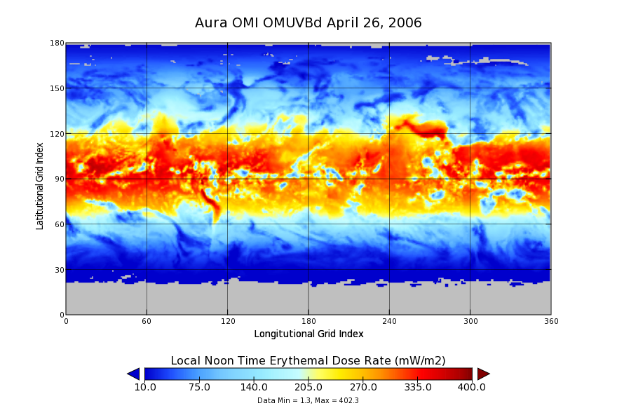
OMI/Aura Surface UVB Irradiance and Erythemal Dose Daily L3 Global Gridded 1.0 degree x 1.0 degree V3 (OMUVBd) at GES DISC recent views
This is Level-3 daily global gridded Aura-OMI Spectral Surface UVB Irradiance and Erythemal Dose product (OMUVBd). The OMUVBd product contains global erythemally weighted daily... -
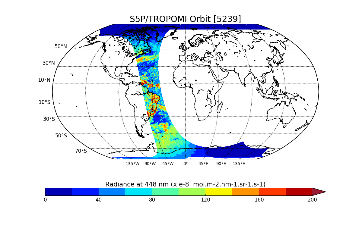
Sentinel-5P TROPOMI Radiance product band 4 (UVIS detector) L1B V1 (S5P_L1B_RA_BD4) at GES DISC recent views
Starting from August 6th in 2019, Sentinel-5P TROPOMI along-track high spatial resolution (~5.5km at nadir) has been implemented. For data after August 6th of 2019, please check... -
AIRS/Aqua L3 8-day Standard Physical Retrieval (AIRS+AMSU+HSB) 1 degree x 1 degree V006 (AIRH3ST8) at GES DISC recent views
The Atmospheric Infrared Sounder (AIRS) is a grating spectrometer (R = 1200) aboard the second Earth Observing System (EOS) polar-orbiting platform, EOS Aqua. In combination... -
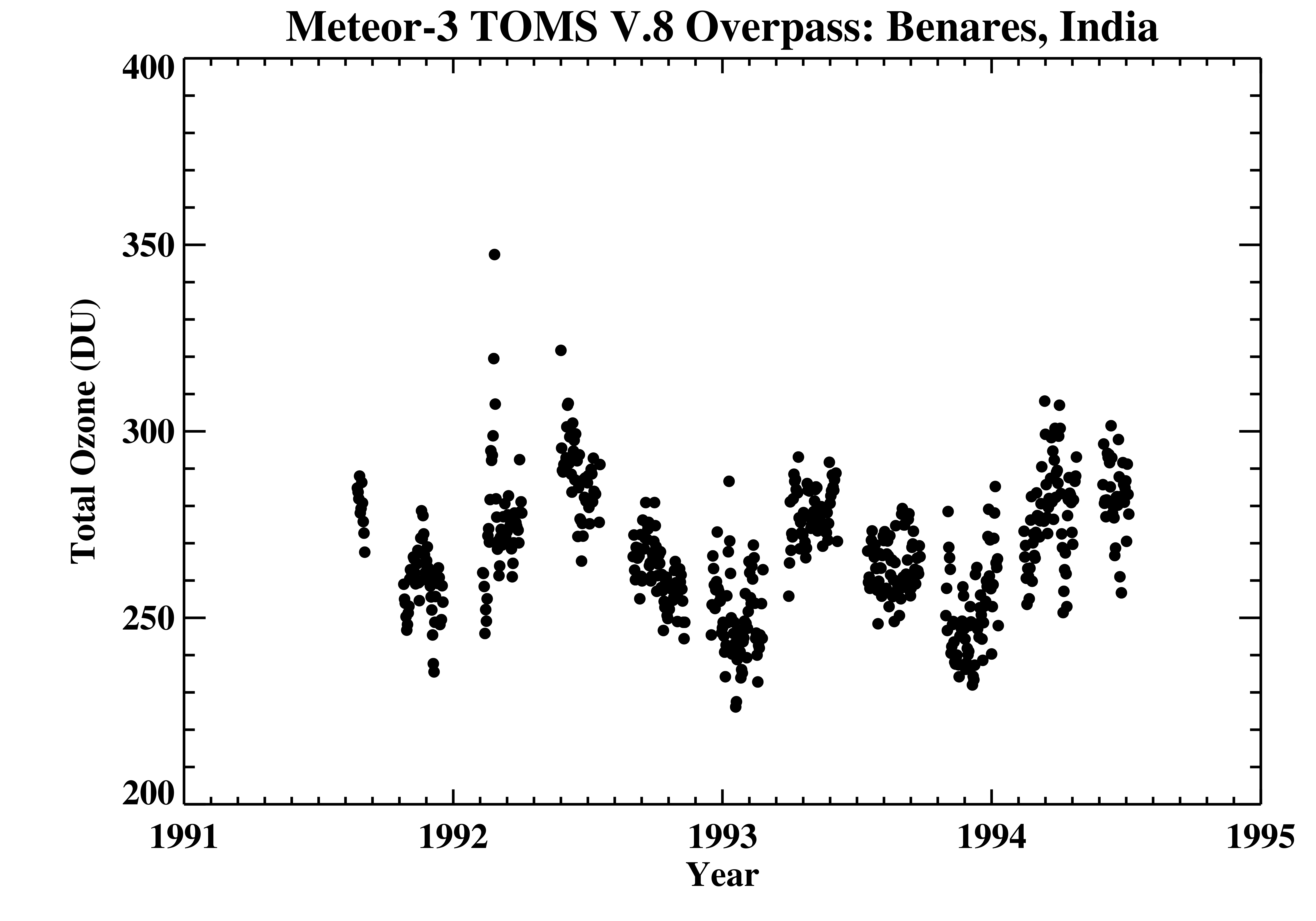
TOMS Meteor-3 Ground Station Overpass Data V008 (TOMSM3OVP) at GES DISC recent views
The Meteor-3 Total Ozone Mapping Spectrometer (TOMS) version 8 daily ground station overpass data product contains total column ozone, UV aerosol index, Lambertian effective... -
Sentinel-5P TROPOMI Radiance product band 2 (UV detector) L1B V1 (S5P_L1B_RA_BD2) at GES DISC recent views
Starting from August 6th in 2019, Sentinel-5P TROPOMI along-track high spatial resolution (~5.5km at nadir) has been implemented. For data after August 6th of 2019, please check... -
CAR SKUKUZA BRDF Measurements L1 V2 (CAR_SKUKUZA_BRDF) at GES DISC recent views
CAR mission Skukuza measured bidirectional reflection functions over different natural surfaces and ecosystems in southern Africa. The measurements were conducted to... -
CAR ECO3D BRDF Measurements V2 (CAR_ECO3D_BRDF) at GES DISC recent views
This study provide critical measurements on 3-dimensional structure of vegetation, which is important for quantifying the amount of carbon stored in biomass. It promotes the... -
NLDAS Noah Land Surface Model L4 Monthly 0.125 x 0.125 degree V2.0 (NLDAS_NOAH0125_M) at GES DISC recent views
This data set contains fifty-two fields simulated from the Noah land-surface model (LSM) for Phase 2 of the North American Land Data Assimilation System (NLDAS-2). The data are... -
GLDAS Catchment Land Surface Model L4 daily 0.25 x 0.25 degree GRACE-DA1 V2.2 (GLDAS_CLSM025_DA1_D_EP) at GES DISC recent views
NASA Global Land Data Assimilation System Version 2 (GLDAS-2) has three components: GLDAS-2.0, GLDAS-2.1, and GLDAS-2.2. GLDAS-2.0 is forced entirely with the Princeton... -
GLDAS Noah Land Surface Model L4 monthly 0.25 x 0.25 degree V2.0 (GLDAS_NOAH025_M) at GES DISC recent views
NASA Global Land Data Assimilation System Version 2 (GLDAS-2) has three components: GLDAS-2.0, GLDAS-2.1, and GLDAS-2.2. GLDAS-2.0 is forced entirely with the Princeton... -
Aqua/AIRS L2 Standard Physical Retrieval (AIRS+AMSU) V7.0 at GES DISC recent views
The Atmospheric Infrared Sounder (AIRS) is a grating spectrometer (R = 1200) aboard the second Earth Observing System (EOS) polar-orbiting platform, EOS Aqua. The AIRS... -
MERRA-2 tavg3_3d_rad_Np: 3d,3-Hourly,Time-Averaged,Pressure-Level,Assimilation,Radiation Diagnostics 0.625 x 0.5 degree V5.12.4 (M2T3NPRAD) at GES DISC recent views
M2T3NPRAD (or tavg3_3d_rad_Np) is a 3-dimensional 3-hourly time averaged data collection in Modern-Era Retrospective analysis for Research and Applications version 2 (MERRA-2).... -
GLDAS Catchment Land Surface Model L4 monthly 1.0 x 1.0 degree V2.1 (GLDAS_CLSM10_M) at GES DISC recent views
NASA Global Land Data Assimilation System Version 2 (GLDAS-2) has three components: GLDAS-2.0, GLDAS-2.1, and GLDAS-2.2. GLDAS-2.0 is forced entirely with the Princeton... -
NLDAS Primary Forcing Data L4 Monthly Climatology 0.125 x 0.125 degree V2.0 (NLDAS_FORA0125_MC) at GES DISC recent views
This data set contains the monthly climatology data of the primary forcing data for Phase 2 of the North American Land Data Assimilation System (NLDAS-2). The data are in 1/8th... -
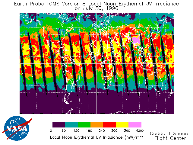
TOMS Earth Probe UV-B Erythemal Local Noon Irradiance Daily L3 Global 1 deg x 1.25 deg Lat/Lon Grid V008 (TOMSEPL3dery) at GES DISC recent views
This Earth Probe (EP) Total Ozone Mapping Spectrometer (TOMS) version 8 daily global gridded data product contains UV-B erythemal local noon irradiance values. The data are...

Official websites use .gov
A
.gov website belongs to an official government
organization in the United States.
Secure .gov websites use HTTPS
A
lock (
) or https:// means you’ve safely connected to
the .gov website. Share sensitive information only on official,
secure websites.