
-
GEOS-Carb CASA-GFED Daily Fire and Fuel Emissions 0.5 degree x 0.5 degree V3 (GEOS_CASAGFED_D_FIRE) at GES DISC
This product provides Daily average wildfire emissions (FIRE) andfuel wood burning emissions (FUEL) derived from the Carnegie-Ames-Stanford-Approach – Global Fire Emissions... -
GPM IMERG Final Precipitation L3 1 day 0.1 degree x 0.1 degree V07 (GPM_3IMERGDF) at GES DISC
Version 07 is the current version of the data set. Older versions will no longer be available and have been superseded by Version 07.The Integrated Multi-satellitE Retrievals... -
HAQAST Sentinel-5P TROPOMI Nitrogen Dioxide (NO2) GLOBAL Monthly Level 3 0.1 x 0.1 Degree Gridded Data Version 2.4 (HAQ_TROPOMI_NO2_GLOBAL_M_L3) at GES DISC
This product provides level 3 monthly averages of tropospheric Nitrogen dioxide (NO2) vertical column density derived from the level 2 Tropospheric Monitoring Instrument... -
Sentinel-6A GNSS-POD Level 1B Daily RINEX V1 (S6A_GN_1B_RNXD_AX_) at GES DISC
This dataset provides the L1B Global Navigation Satellite System (GNSS) Precise Orbit Determination (POD) data generated by European Organisation for the Exploitation of... -
TERRA MODIS High Resolution Level 3 daily aerosol data, 0.1x0.1 degree grid Version 001 (AER_DBDT_D10KM_L3_MODIS_TERRA) at GES DISC
This High-Resolution (0.1 x 0.1 degree) Level 3 daily Aerosol Optical Depth (AOD) product is generated by combining two Moderate Resolution Imaging Spectroradiometer (MODIS)... -
TROPESS Chemical Reanalysis Surface Pressure Monthly 2-dimensional Product V1 (TRPSCRPSM2D) at GES DISC
The TROPESS Chemical Reanalysis PS Monthly 2-dimensional Product contains surface pressure values, a meteorological field. The data are part of the Tropospheric Chemical... -
Global Landslide Nowcast from LHASA L4 1 day 1 km x 1 km version 1.1 (Global_Landslide_Nowcast) at GES DISC
The Landslide Hazard Assessment for Situational Awareness (LHASA) model identifies locations with high potential for landslide occurrence at a daily temporal resolution. LHASA... -
GPM SSMIS on F16 (GPROF) Climate-based Radiometer Precipitation Profiling L3 1 month 0.25 degree x 0.25 degree V07 (GPM_3GPROFF16SSMIS_CLIM) at GES DISC
Version 07 is the current version of the data set. Older versions will no longer be available and have been superseded by Version 07. The "CLIM" products differ from their... -
SBUV2/NOAA-18 Ozone (O3) Profile and Total Column Ozone 1 Month Zonal Mean L3 Global 5.0 degree Latitude Zones V1 (SBUV2N18L3zm) at GES DISC
The Solar Backscattered Ultraviolet (SBUV) from NOAA-18 Level-3 monthly zonal mean (MZM) product (SBUV2N18L3zm) is derived from the Level-2 retrieved ozone profiles. Ozone... -
Sounder SIPS: JPSS-1 ATMS Level 3 RAMSES2 Standard Gridded Monthly V3 at GES DISC
This level 3 monthly product is generated from the RAMSES (Retrieval Algorithm for Microwave Sounders in Earth Science) II algorithm.The RAMSES II algorithm is a microwave only... -
MRIR/Nimbus-3 Images of Daytime Brightness Temperature on 4 x 5 inch Film Sheets V001 (MRIRN3IM) at GES DISC
MRIRN3IM is the Nimbus-3 Medium Resolution Infrared Radiometer (MRIR) data product consisting of 4 x 5 inch photographic film sheets. Each film sheet contains an entire orbit... -
GPM AMSU-B on NOAA 16 Common Calibrated Brightness Temperatures L1C 1.5 hours 16 km V07 (GPM_1CNOAA16AMSUB) at GES DISC
Version 07 is the current version of the data set. Older versions will no longer be available and have been superseded by Version 07.All 1C products have a common L1C data... -
MLS/Aura Level 3 Daily Binned Methyl Chloride (CH3Cl) Mixing Ratio on Assorted Grids V004 (ML3DBCH3CL) at GES DISC
ML3DBCH3CL is the EOS Aura Microwave Limb Sounder (MLS) daily binned on various vertical grids product for methyl chloride (CH3Cl) derived from radiances measured by the 640 GHz... -
MLS/Aura Level 3 Daily Binned Relative Humidity With Respect To Ice (RHI) on Assorted Grids V005 (ML3DBRHI) at GES DISC
ML3DBRHI is the EOS Aura Microwave Limb Sounder (MLS) daily binned on various vertical grids product for relative humidity with respect to ice (RHI) derived from radiances... -
GPM SSMI on F08 (GPROF) Climate-based Radiometer Precipitation Profiling L3 1 day 0.25 degree x 0.25 degree V07 (GPM_3GPROFF08SSMI_DAY_CLIM) at GES DISC
Version 7 is the current version of the data set. Older versions will no longer be available and have been superseded by the current version. The "CLIM" products differ from... -
GPM SSMI on F14 (GPROF) Climate-based Radiometer Precipitation Profiling L3 1 month 0.25 degree x 0.25 degree V07 (GPM_3GPROFF14SSMI_CLIM) at GES DISC
Version 07 is the current version of the data set. Older versions will no longer be available and have been superseded by Version 07. The "CLIM" products differ from their... -
Daily FluxSat GPP of biomass over Land, Based on MODIS Terra and Aqua adjusted reflectance Collection 6.1, on a Global 0.5 by 0.625 Degree Grid, Level 3 Version 2.2
This dataset provides global gridded daily estimates of gross primary production (GPP) and uncertainties at 0.5 deg latitude by 0.625 deg longitude resolution for the period... -
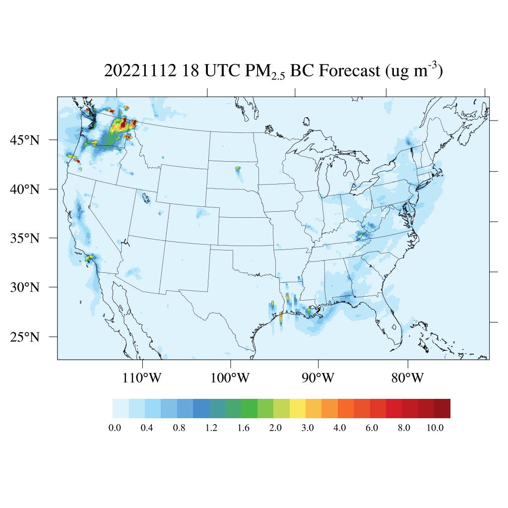
HAQES 3-Hourly Ensemble mean surface PM2.5 Black Carbon concentration, North America V1 (HAQES_NA_PM25_BC) at GES DISC
This product provides HAQES 3-hourly ensemble mean surface PM2.5 Black Carbon concentration over the continental United States (CONUS) and surrounding regions. The data is... -
NASA Ocean Biogeochemical Model assimilating satellite chlorophyll data global monthly VR2017 (NOBM_MON) at GES DISC
This is the assimilated monthly data from NASA Ocean Biogeochemical Model (NOBM). The NOBM is a comprehensive, interactive ocean biogeochemical model coupled with a circulation...

Official websites use .gov
A
.gov website belongs to an official government
organization in the United States.
Secure .gov websites use HTTPS
A
lock (
) or https:// means you’ve safely connected to
the .gov website. Share sensitive information only on official,
secure websites.