
-
Arctic Vegetation Plots at Atqasuk, Alaska, 1975, 2000, and 2010 recent views
This data set provides vegetation species abundance data collected in 1975 from 60 sites on the Arctic Coastal Plain near Atqasuk, Alaska, as well as environmental and species... -
Arctic Boreal Annual Burned Area, Circumpolar Boreal Forest and Tundra, V2, 2002-2022 NGDA recent views
This dataset provides annual cumulative end-of-season burned area in circumpolar boreal forests and tundra for the years 2002-2022. The data were generated using the Arctic... -
NACP Regional: National Greenhouse Gas Inventories and Aggregated Gridded Model Data recent views
This data set provides two products that were derived from the recently published North American Carbon Program (NACP) Regional Synthesis 1-degree terrestrial biosphere model... -
Forest Inventory and Biophysical Measurements, Brazilian Amazon, 2009-2018 recent views
This dataset provides the complete catalog of forest inventory and biophysical measurements collected over selected forest research sites across the Amazon rainforest in Brazil... -
Global Aboveground and Belowground Biomass Carbon Density Maps for the Year 2010 recent views
This dataset provides temporally consistent and harmonized global maps of aboveground and belowground biomass carbon density for the year 2010 at a 300-m spatial resolution. The... -
Global Forest Ecosystem Structure and Function Data For Carbon Balance Research recent views
A comprehensive global database has been assembled to quantify CO2 fluxes and pathways across different levels of integration (from photosynthesis up to net ecosystem... -
ABoVE: Distribution Maps of Wildland Fire Fuel Components across Alaskan Tundra, 2015 recent views
This dataset provides maps of the distribution of three major wildland fire fuel types at 30 m spatial resolution covering the Alaskan arctic tundra, circa 2015. The three fuel... -
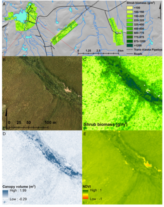
High-Resolution Shrub Biomass and Uncertainty Maps, Toolik Lake Area, Alaska, 2013 recent views
This dataset contains estimates for aboveground shrub biomass and uncertainty at high spatial resolution (0.80-m) across three research areas near Toolik Lake, Alaska. The... -
ABoVE: Needle-Level Chlorophyll Fluorescence, Alaska and Idaho, USA, 2017 and 2019 recent views
This dataset provides the results of in situ measurements of needle-level chlorophyll fluorescence (ChlF) obtained from a pulse amplitude modulated (PAM) fluorometer from... -
Aboveground Biomass Density for High Latitude Forests from ICESat-2, 2020 recent views
This dataset provides estimates of Aboveground dry woody Biomass Density (AGBD) for high northern latitude forests at a 30-m spatial resolution. It is designed both for boreal-... -
ABoVE: Modeled Top Cover by Plant Functional Type over Alaska and Yukon, 1985-2020 recent views
This dataset contains data files of modeled top cover estimates by plant functional type (PFT) for the Arctic and Boreal Alaska and Yukon regions. Estimates are presented for... -
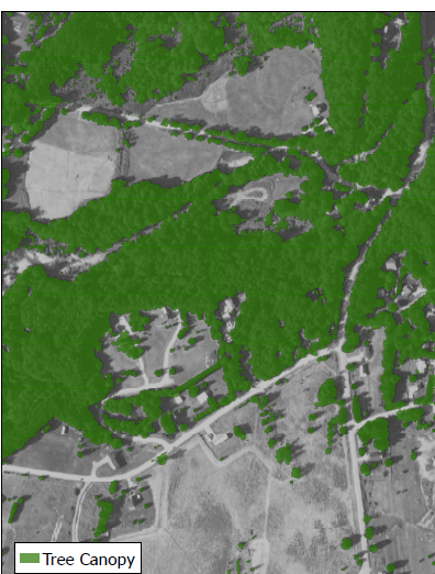
Ground-Based Vegetation Community Photos, Toolik Lake Area, Alaska, 2014-2015 recent views
This dataset contains 731 ground-based nadir vegetation community and ground surface photographs of selected field plots taken as ground reference data for vegetation... -
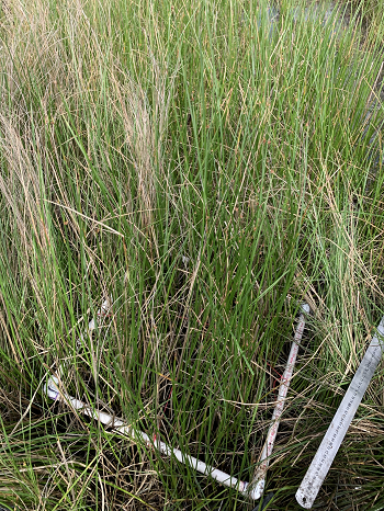
Delta-X: Aboveground Biomass and Necromass across Wetlands, MRD, Louisiana, 2021, V2 recent views
This dataset contains total aboveground biomass (AGB) and necromass (AGN), and total carbon, total nitrogen, and total phosphorus content of aboveground biomass (AGB) and... -
Urban Biogenic CO2 fluxes: GPP, Reco and NEE Estimates from SMUrF, 2010-2019 NGDA recent views
This dataset contains estimates of biogenic CO2 flux components at 0.05 degree resolution from the Solar-Induced Fluorescence (SIF) for Modeling Urban biogenic Fluxes (SMUrF)... -
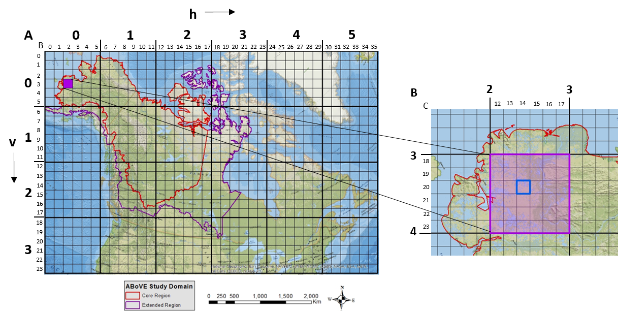
ABoVE: Study Domain and Standard Reference Grids, Version 2 recent views
The Arctic - Boreal Vulnerability Experiment (ABoVE) has developed two standardized spatial data products to expedite coordination of research activities and to facilitate data... -
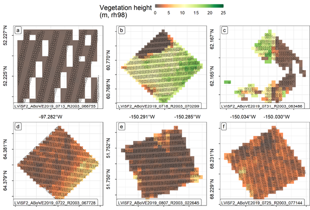
ABoVE: LVIS L3 Gridded Vegetation Structure across North America, 2017 and 2019 recent views
This dataset provides Level 3 (L3) footprint-level gridded metrics and attributes collected from NASA's Land, Vegetation, and Ice Sensor (LVIS)-Facility instrument for each...

Official websites use .gov
A
.gov website belongs to an official government
organization in the United States.
Secure .gov websites use HTTPS
A
lock (
) or https:// means you’ve safely connected to
the .gov website. Share sensitive information only on official,
secure websites.