
-
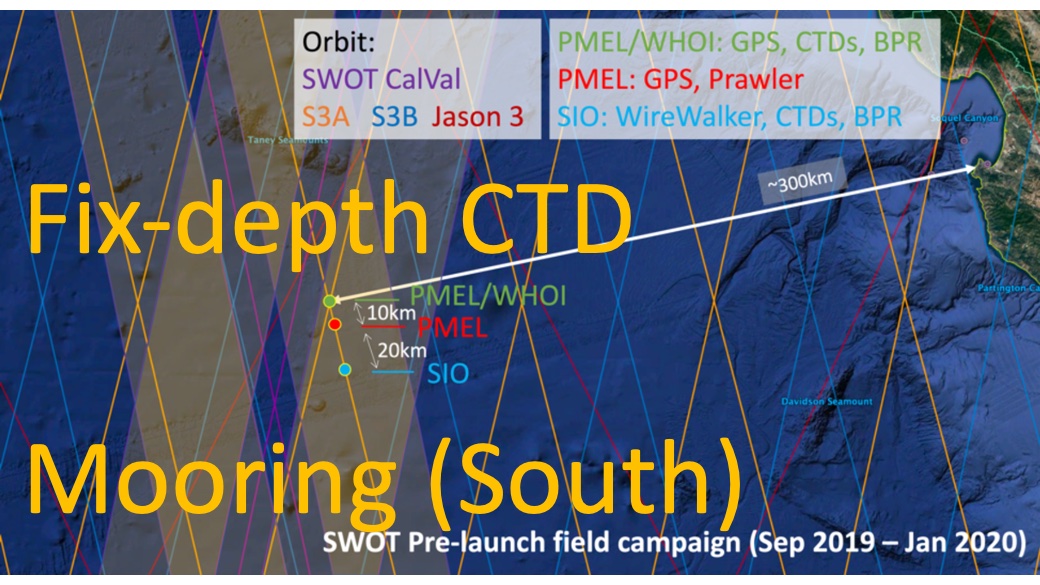
SWOT 2019-2020 Prelaunch Oceanography Field Campaign SIO Moored Fixed-Depth CTDs recent views
This dataset provides the conductivity, temperature and depth (CTD) measurements from the fixed-depth CTD sensors mounted on a full-depth mooring deployed by the SWOT prelaunch... -
ECCO Sea-Ice Salt Plume Fluxes - Monthly Mean llc90 Grid (Version 4 Release 4) recent views
This dataset provides monthly-averaged sea-ice salt plume fluxes on the native Lat-Lon-Cap 90 (LLC90) model grid from the ECCO Version 4 Release 4 (V4r4) ocean and sea-ice state... -
Aquarius Official Release Level 3 Sea Surface Salinity Standard Mapped Image Descending Daily Data V5.0 recent views
Aquarius Level 3 sea surface salinity (SSS) standard mapped image data contains gridded 1 degree spatial resolution SSS averaged over daily, 7 day, monthly, and seasonal time... -
OMG Narwhals Shipboard Conductivity, Temperature, and Depth (CTD) profiles, 2018-2020 recent views
This OMG Narwhals dataset contains measurements from the ship based full water column CTD profiles that were obtained during summer mooring deployment/recovery cruises. NASA’s... -
Aquarius Official Release Level 3 Sea Surface Salinity Standard Mapped Image Seasonal Data V5.0 recent views
Aquarius Level 3 sea surface salinity (SSS) standard mapped image data contains gridded 1 degree spatial resolution SSS averaged over daily, 7 day, monthly, and seasonal time... -
SASSIE Arctic Field Campaign Shipboard Salinity Snake Data Fall 2022 recent views
The Salinity and Stratification at the Sea Ice Edge (SASSIE) project is a NASA experiment that aims to understand how salinity anomalies in the upper ocean generated by melting... -
Aquarius Official Release Level 3 Sea Surface Salinity Standard Mapped Image Monthly Climatology Data V5.0 recent views
Aquarius Level 3 sea surface salinity (SSS) standard mapped image data contains gridded 1 degree spatial resolution SSS averaged over daily, 7 day, monthly, and seasonal time... -
ECCO Ocean Density, Stratification, and Hydrostatic Pressure - Daily Mean 0.5 Degree (Version 4 Release 4) recent views
This dataset contains daily-averaged ocean density, stratification, and hydrostatic pressure interpolated to a regular 0.5-degree grid from the ECCO Version 4 revision 4 (V4r4)... -
RSS SMAP Level 2C Sea Surface Salinity V5.0 Validated Dataset recent views
The version 5.0 SMAP-SSS, level 2C product contains the fourth release of the validated sea surface salinity orbital/swath data from the NASA Soil Moisture Active Passive (SMAP)... -
ECCO Ocean Density, Stratification, and Hydrostatic Pressure - Monthly Mean 0.5 Degree (Version 4 Release 4) recent views
This dataset contains monthly-averaged ocean density, stratification, and hydrostatic pressure interpolated to a regular 0.5-degree grid from the ECCO Version 4 revision 4... -
ECCO Ocean Temperature and Salinity - Daily Mean 0.5 Degree (Version 4 Release 4) recent views
This dataset contains daily-averaged ocean potential temperature and salinity interpolated to a regular 0.5-degree grid from the ECCO Version 4 revision 4 (V4r4) ocean and sea-... -
Aquarius Official Release Level 3 Sea Surface Density Standard Mapped Image Ascending Daily Data V5.0 recent views
Aquarius Level 3 sea surface density standard mapped image data contains gridded 1 degree spatial resolution density data averaged over daily, 7 day, monthly, and seasonal time... -
ECCO Ocean Temperature and Salinity - Daily Mean llc90 Grid (Version 4 Release 4) recent views
This dataset provides daily-averaged ocean potential temperature and salinity on the native Lat-Lon-Cap 90 (LLC90) model grid from the ECCO Version 4 Release 4 (V4r4) ocean and... -
Aquarius CAP Level 2 Sea Surface Salinity, Wind Speed & Direction Data V5.0 recent views
The version 5.0 Aquarius CAP Level 2 product contains the fourth release of the AQUARIUS/SAC-D orbital/swath data based on the Combined Active Passive (CAP) algorithm. CAP is a... -
RSS SMAP Level 2C Sea Surface Salinity NRT V5.0 Validated Dataset recent views
The version 5.0 SMAP-SSS, level 2C product contains the fourth release of the validated sea surface salinity orbital/swath data from the NASA Soil Moisture Active Passive (SMAP)... -
Boknis Pre-SWOT Level-4 Hourly MITgcm LLC4320 Native Grid 2km Oceanographic Dataset Version 1.0 recent views
This dataset provides a regional multivariate oceanographic state estimate from a global ocean numerical simulation with a focus on the Baltic Sea region. The global ocean... -
S-MODE NCOM Model Output Version 1 recent views
This dataset contains model output from the Navy Coastal Ocean Model (NCOM) run during the Sub-Mesoscale Ocean Dynamics Experiment (S-MODE) field campaign. S-MODE aims to... -
OMG Conductivity Temperature Depth (CTD) Profiles recent views
This dataset contains in situ measurements from Conductivity Temperature Depth (CTD) casts and tows. It provides salinity, density, temperature and sound velocity of the water... -
Aquarius Official Release Level 3 Sea Surface Density Standard Mapped Image Ascending Seasonal Data V5.0 recent views
Aquarius Level 3 sea surface density standard mapped image data contains gridded 1 degree spatial resolution density data averaged over daily, 7 day, monthly, and seasonal time... -
ECCO Ocean Three-Dimensional Salinity Fluxes - Daily Mean llc90 Grid (Version 4 Release 4) recent views
This dataset provides daily-averaged ocean three-dimensional salinity fluxes on the native Lat-Lon-Cap 90 (LLC90) model grid from the ECCO Version 4 Release 4 (V4r4) ocean and...

Official websites use .gov
A
.gov website belongs to an official government
organization in the United States.
Secure .gov websites use HTTPS
A
lock (
) or https:// means you’ve safely connected to
the .gov website. Share sensitive information only on official,
secure websites.