
-
Ocean Surface Current Analyses Real-time (OSCAR) Surface Currents - Final 0.25 Degree (Version 2.0) recent views
Ocean Surface Current Analyses Real-time (OSCAR) is a global surface current database and NASA funded research project. OSCAR ocean mixed layer velocities are calculated from... -
SWOT Level 2 Lake Single-Pass Vector Data Product, Version 2.0 recent views
The SWOT Level 2 Lake Single-Pass Vector Data Product from the Surface Water Ocean Topography (SWOT) mission provides water surface elevation, area, storage change derived from... -
MEaSUREs Gridded Sea Surface Height Anomalies Version 2205 recent views
This dataset provides gridded Sea Surface Height Anomalies (SSHA) above a mean sea surface, on a 1/6th degree grid every 5 days. It contains the fully corrected heights, with a... -
SWOT Level 2 River Single-Pass Vector Data Product, Version 1.1 recent views
Shapefiles of river reaches (approximately 10 km long) and nodes (approximately 200 m spacing) identified in prior river database. Reach attributes include water surface... -
CYGNSS Level 2 Science Data Record Version 3.1 recent views
This dataset contains the Version 3.1 CYGNSS Level 2 Science Data Record which provides the time-tagged and geolocated average wind speed (m/s) and mean square slope (MSS) with... -
CYGNSS Level 1 Raw Intermediate Frequency Data Record recent views
This Level 1 (L1) dataset contains the Raw Intermediate Frequency (IF) sensor data from the Delay Doppler Mapping Instrument aboard the CYGNSS satellite constellation. The... -
ECCO Ocean and Sea-Ice Surface Heat Fluxes - Monthly Mean llc90 Grid (Version 4 Release 4) recent views
This dataset provides monthly-averaged ocean and sea-ice surface heat fluxes on the native Lat-Lon-Cap 90 (LLC90) model grid from the ECCO Version 4 Release 4 (V4r4) ocean and... -
MODIS Aqua Level 3 SST Thermal IR Monthly 4km Daytime V2019.0 NGDA recent views
Day and night spatially gridded (L3) global NASA skin sea surface temperature (SST) products from the Moderate-resolution Imaging Spectroradiometer (MODIS) onboard the Aqua... -
SWOT Level 2 Water Mask Pixel Cloud Auxiliary Data Product, Version 1.1 recent views
Auxiliary information for pixel cloud product indicating to which water bodies the pixels are assigned in river and lake products. Also includes height-constrained pixel... -
ECCO Gent-McWilliams Ocean Bolus Velocity - Daily Mean llc90 Grid (Version 4 Release 4) recent views
This dataset provides daily-averaged Gent-McWilliams ocean bolus velocity on the native Lat-Lon-Cap 90 (LLC90) model grid from the ECCO Version 4 Release 4 (V4r4) ocean and sea-... -
GHRSST NOAA/STAR GOES-17 ABI L3C America Region SST v2.71 dataset in GDS2 recent views
The ACSPO G17/ABI L3C (Level 3 Collated) product is a gridded version of the ACSPO G17/ABI L2P product available at https://podaac.jpl.nasa.gov/dataset/ABI_G17-STAR-L2P-v2.71.... -
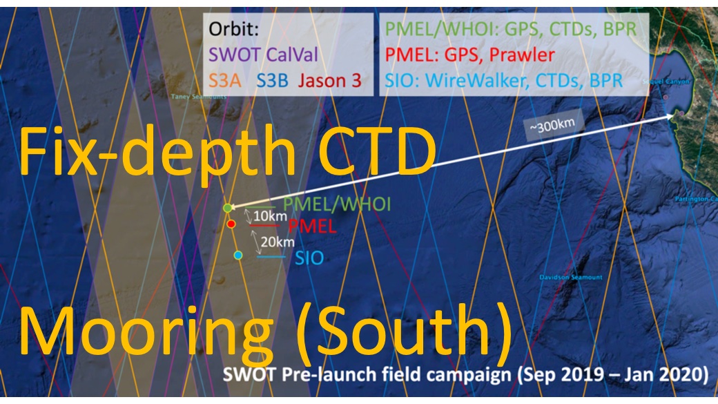
SWOT 2019-2020 Prelaunch Oceanography Field Campaign SIO Moored Fixed-Depth CTDs recent views
This dataset provides the conductivity, temperature and depth (CTD) measurements from the fixed-depth CTD sensors mounted on a full-depth mooring deployed by the SWOT prelaunch... -
SPURS-2 Passive Accoustic Listener (PAL) data from ARGO float deployments during the E. Tropical Pacific field campaign recent views
The SPURS (Salinity Processes in the Upper Ocean Regional Study) project is a NASA-funded oceanographic process study and associated field program that aim to elucidate key... -
GHRSST NOAA/STAR Metop-A AVHRR FRAC ACSPO v2.80 1km L2P Dataset (GDS v2) recent views
The MetOp First Generation (FG) is a European multi-satellite program jointly established by ESA and EUMETSAT, comprising three satellites, MetOp-A, -B and -C. The primary... -
ECCO Ocean Velocity - Monthly Mean 0.5 Degree (Version 4 Release 4) recent views
This dataset contains monthly-averaged ocean velocity interpolated to a regular 0.5-degree grid from the ECCO Version 4 revision 4 (V4r4) ocean and sea-ice state estimate.... -
ECCO Gent-McWilliams Ocean Bolus Velocity - Monthly Mean 0.5 Degree (Version 4 Release 4) recent views
This dataset contains monthly-averaged Gent-McWilliams ocean bolus velocity interpolated to a regular 0.5-degree grid from the ECCO Version 4 revision 4 (V4r4) ocean and sea-ice... -
ECCO Sea-Ice Salt Plume Fluxes - Monthly Mean llc90 Grid (Version 4 Release 4) recent views
This dataset provides monthly-averaged sea-ice salt plume fluxes on the native Lat-Lon-Cap 90 (LLC90) model grid from the ECCO Version 4 Release 4 (V4r4) ocean and sea-ice state... -
Aquarius Official Release Level 3 Sea Surface Salinity Standard Mapped Image Descending Daily Data V5.0 recent views
Aquarius Level 3 sea surface salinity (SSS) standard mapped image data contains gridded 1 degree spatial resolution SSS averaged over daily, 7 day, monthly, and seasonal time... -
UC Berkeley CYGNSS Level 3 Monthly RWAWC Watermask Version 3.1 recent views
The CYGNSS Level 3 UC Berkeley Watermask Record Version 3.1 was developed by CYGNSS investigators in the Department of Civil and Environmental Engineering at the University of...

Official websites use .gov
A
.gov website belongs to an official government
organization in the United States.
Secure .gov websites use HTTPS
A
lock (
) or https:// means you’ve safely connected to
the .gov website. Share sensitive information only on official,
secure websites.