

7 datasets found
-
Federal
W00006: NOS Hydrographic Survey , Outside Source Data - 2001, 2001-03-20
National Oceanic and Atmospheric Administration, Department of Commerce —
The National Oceanic and Atmospheric Administration (NOAA) has the statutory mandate to collect hydrographic data in support of nautical chart compilation for safe... -
Federal
H13577: NOS Hydrographic Survey , 2022-06-02
National Oceanic and Atmospheric Administration, Department of Commerce —
The National Oceanic and Atmospheric Administration (NOAA) has the statutory mandate to collect hydrographic data in support of nautical chart compilation for safe... -
Federal
W00157: NOS Hydrographic Survey , Outside Source Data Surveys - 2009, 2003-09-29
National Oceanic and Atmospheric Administration, Department of Commerce —
The National Oceanic and Atmospheric Administration (NOAA) has the statutory mandate to collect hydrographic data in support of nautical chart compilation for safe... -
Federal
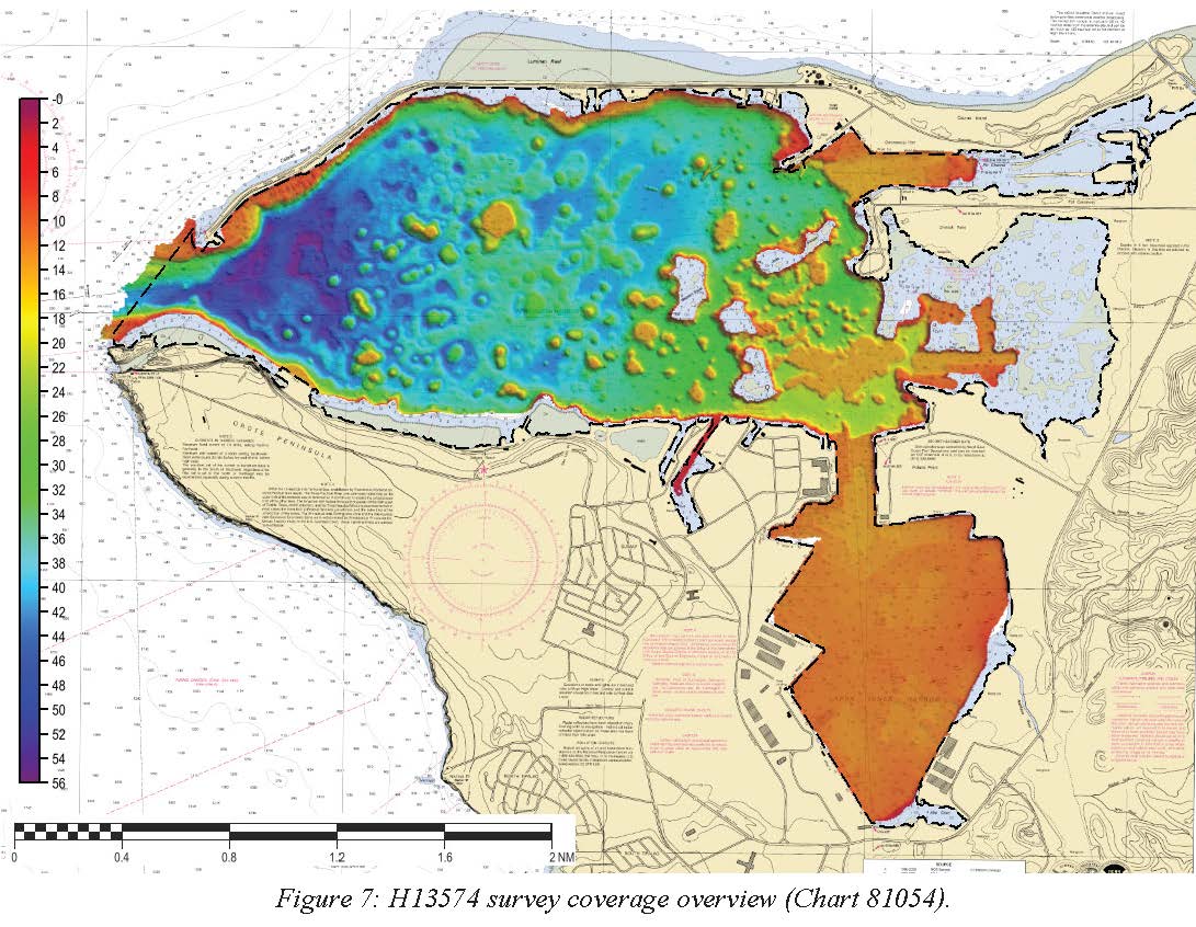
H13574: NOS Hydrographic Survey , 2022-07-09
National Oceanic and Atmospheric Administration, Department of Commerce —
The National Oceanic and Atmospheric Administration (NOAA) has the statutory mandate to collect hydrographic data in support of nautical chart compilation for safe... -
Federal
Mariana Trench 6 arc-second Bathymetric Digital Elevation Model
National Oceanic and Atmospheric Administration, Department of Commerce —
NOAA's National Geophysical Data Center (NGDC) created a bathymetric digital elevation model (DEM) for the Mariana Trench and adjacent seafloor in the Western Pacific... -
Federal
Apra Harbor, Guam Tsunami Forecast Grids for MOST Model
National Oceanic and Atmospheric Administration, Department of Commerce —
The Apra Harbor, Guam Forecast Model Grids provides bathymetric data strictly for tsunami inundation modeling with the Method of Splitting Tsunami (MOST) model. MOST... -
Federal
Guam 1/3 arc-second MHW Coastal Digital Elevation Model
National Oceanic and Atmospheric Administration, Department of Commerce —
The 1/3-second Guam Elevation Grid provides bathymetric data of 1/3-second resolution in geographic coordinates. This grid is strictly for tsunami inundation modeling
7 datasets found