
-
Federal
Benthic Habitats of Hawaii Derived From IKONOS and Quick Bird Satellite Imagery, 2004-2007 recent views
National Oceanic and Atmospheric Administration, Department of Commerce —
This project is a cooperative effort between the National Ocean Service, National Centers for Coastal Ocean Science, Center for Coastal Monitoring and Assessment, the... -
Federal
Predicted Habitat Suitability for Leptoseris in the Au'au Channel Region recent views
National Oceanic and Atmospheric Administration, Department of Commerce —
This raster denotes predicted habitat suitability for Leptoseris in the Au'au Channel region. Maximum Entropy (MaxEnt) modeling software was used to create this... -
Federal
Shallow-water Benthic Habitats in Jobos Bay recent views
National Oceanic and Atmospheric Administration, Department of Commerce —
Shallow-water (<30m) benthic habitat maps of the nearshore marine environment of Jobos Bay, Puerto Rico were mapped and characterized using visual interpretation... -
Federal
Predicted Habitat Suitability for All Mesophotic Corals in the Au'au Channel Region recent views
National Oceanic and Atmospheric Administration, Department of Commerce —
This dataset is located between the islands of Maui, Lanai, Molokai and Kahoolawe, and includes the Au'au Channel as well as parts of the Kealaikahiki, Alalakeiki and... -
Federal
Benthic Habitats of Kauai Derived From IKONOS and Quick Bird Satellite Imagery, 2004-2006 recent views
National Oceanic and Atmospheric Administration, Department of Commerce —
This project is a cooperative effort between the National Ocean Service, National Centers for Coastal Ocean Science, Center for Coastal Monitoring and Assessment, the... -
Federal
NOAA Environmental Sensitivity Index (ESI) maps and geographic information systems data from 1900 to 2009 recent views
National Oceanic and Atmospheric Administration, Department of Commerce —
This collection comprises the Environmental Sensitivity Index (ESI) data for various regions in U.S. coastal waters. ESI data characterize estuarine environments and... -
Federal
CRED Cumulative Map of Percent Scleractinian Coral Cover at Zealandia recent views
National Oceanic and Atmospheric Administration, Department of Commerce —
This map displays optical validation observation locations and percent coverage of scleractinian coral overlaid on bathymetry. -
Federal
CRED Cumulative Map of Percent Scleractinian Coral Cover at Arakane recent views
National Oceanic and Atmospheric Administration, Department of Commerce —
This map displays optical validation observation locations and percent coverage of scleractinian coral overlaid on bathymetry. -
Federal
Hawaii Hamakua IKONOS and Quickbird Imagery - Mosaic recent views
National Oceanic and Atmospheric Administration, Department of Commerce —
This project is a cooperative effort between the National Ocean Service, National Centers for Coastal Ocean Science, Center for Coastal Monitoring and Assessment, BAE... -
Federal
Habitat Zone, Cover and Structure Maps of the Rota, Southern Mariana Archipelago 2001-2003, Derived from IKONOS Imagery recent views
National Oceanic and Atmospheric Administration, Department of Commerce —
This project is a cooperative effort between the National Ocean Service, National Centers for Coastal Ocean Science, Center for Coastal Monitoring and Assessment, the... -
Federal
NCCOS Assessment: Benthic habitat maps of Saipan Lagoon, Commonwealth of the Northern Mariana Islands (NCEI Accession 0162517) recent views
National Oceanic and Atmospheric Administration, Department of Commerce —
Highly detailed maps of benthic habitats within the lagoon along the western shore of Saipan were created by NOAA NCCOS. This data collection includes the information... -
Federal
CRED Cumulative Map of Percent Scleractinian Coral Cover at Pearl and Hermes Atoll, 2002-2004 recent views
National Oceanic and Atmospheric Administration, Department of Commerce —
This map displays optical validation observation locations and percent coverage of scleractinian coral overlaid on bathymetry. -
Federal
CRED Cumulative Map of Percent Scleractinian Coral Cover at Johnston Atoll, 2004 recent views
National Oceanic and Atmospheric Administration, Department of Commerce —
This map displays optical validation observation locations and percent coverage of scleractinian coral overlaid on bathymetry. -
Federal
Benthic Habitat and Zone Maps of Puerto Rico 1999 - Prepared by Visual Interpretation from Remote Sensing Imagery Collected by NOAA, 1999 recent views
National Oceanic and Atmospheric Administration, Department of Commerce —
There are 208 habitat and zone maps of Puerto Rico and is major islands. This project is a cooperative effort between the National Ocean Service, National Centers for... -
Federal
Oahu IKONOS and Quickbird Imagery - Mosaic recent views
National Oceanic and Atmospheric Administration, Department of Commerce —
This project is a cooperative effort between the National Ocean Service, National Centers for Coastal Ocean Science, Center for Coastal Monitoring and Assessment, BAE... -
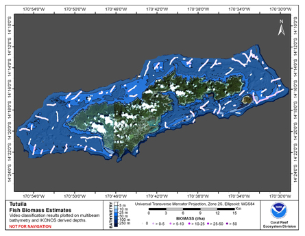
Federal
CRED Cumulative Fish Biomass map at Tutuila Island recent views
National Oceanic and Atmospheric Administration, Department of Commerce —
This map displays fish biomass observation locations overlaid on bathymetry. -
Federal
Map of percent scleractinian coral cover and sand along camera tow tracks in west Hawaii recent views
National Oceanic and Atmospheric Administration, Department of Commerce —
This map displays optical validation observation locations and percent coverage of scleractinian coral and sand overlaid on bathymetry and landsat imagery northwest... -
Federal
Benthic Habitat Type Maps of the Niihau Island 2000 - Prepared by Visual Interpretation from Remote Sensing Imagery Collected by NOAA recent views
National Oceanic and Atmospheric Administration, Department of Commerce —
Four habitat and zone maps. This project is a cooperative effort between the National Ocean Service, National Centers for Coastal Ocean Science, Center for Coastal... -
Federal
Hawaii Leeward IKONOS and Quickbird Imagery - Mosaic recent views
National Oceanic and Atmospheric Administration, Department of Commerce —
This project is a cooperative effort between the National Ocean Service, National Centers for Coastal Ocean Science, Center for Coastal Monitoring and Assessment, BAE... -
Federal
Map of percent scleractinian coral cover and sand along camera tows and ROV tracks of West Maui, Hawaii recent views
National Oceanic and Atmospheric Administration, Department of Commerce —
This map displays optical validation observation locations and percent coverage of scleractinian coral and sand overlaid on bathymetry and landsat imagery. Optical...

Official websites use .gov
A
.gov website belongs to an official government
organization in the United States.
Secure .gov websites use HTTPS
A
lock (
) or https:// means you’ve safely connected to
the .gov website. Share sensitive information only on official,
secure websites.