
-
Federal
Coastal Mapping Program of Caxambas Pass to Tripod Key, FL, FL1604B-TB-N NGDA recent views
National Oceanic and Atmospheric Administration, Department of Commerce —
These data provide an accurate high-resolution shoreline compiled from imagery of Caxambas Pass to Tripod Key, FL . This vector shoreline data is based on an office... -
Federal
Coastal Mapping Program of Intracoastal Waterway, Wabasso to Fort Pierce, FL, FL2201G-TB-C NGDA recent views
National Oceanic and Atmospheric Administration, Department of Commerce —
These data provide an accurate high-resolution shoreline compiled from imagery of Intracoastal Waterway, Wabasso to Fort Pierce, FL . This vector shoreline data is... -
Federal
2021 NOAA NGS Topobathy Lidar: Gloucester, MA recent views
National Oceanic and Atmospheric Administration, Department of Commerce —
These data were collected by the National Oceanic Atmospheric Administration National Geodetic Survey Remote Sensing Division using a Leica Chiroptera 4X system. The... -
Federal
Recent Buoy Observations from the National Data Buoy Center(NDBC) recent views
National Oceanic and Atmospheric Administration, Department of Commerce —
The National Data Buoy Center (NDBC) maintains a database of near realtime observational recordings for buoys. This database contains not only NDBC buoys but also... -
Federal
Near-Real Time Surface Ocean Velocity, Hawaii, 6 km Resolution recent views
National Oceanic and Atmospheric Administration, Department of Commerce —
Surface ocean velocities estimated from HF-Radar (HFR) are representative of the upper 0.3 - 2.5 meters of the ocean. The main objective of near-real time processing... -
Federal
NOAA GOES-R Series Advanced Baseline Imager (ABI) Level 2 Cloud Cover Layers (CCL) recent views
National Oceanic and Atmospheric Administration, Department of Commerce —
The GOES-R Advanced Baseline Imager (ABI) Cloud Cover Layers (CCL) product contains estimates of cloud fraction between predefined atmospheric levels, as well as, the... -
Federal
Meteorological Data (including visibility) recent views
National Oceanic and Atmospheric Administration, Department of Commerce —
The National Ocean Service (NOS) maintains a long-term database containing data from active and historic stations installed all over the United States and U.S.... -
Federal
NOAA Next Generation Radar (NEXRAD) Level 2 Base Data recent views
National Oceanic and Atmospheric Administration, Department of Commerce —
This dataset consists of Level II weather radar data collected from Next-Generation Radar (NEXRAD) stations located in the contiguous United States, Alaska, Hawaii,... -
Federal
F00617: NOS Hydrographic Survey , Arctic Wreck Investigations. AK, 2012-08-10 recent views
National Oceanic and Atmospheric Administration, Department of Commerce —
The National Oceanic and Atmospheric Administration (NOAA) has the statutory mandate to collect hydrographic data in support of nautical chart compilation for safe... -
Federal
2018 - 2020 NOAA USGS Lidar: Hawaii, HI recent views
National Oceanic and Atmospheric Administration, Department of Commerce —
Product: Processed, classified lidar point cloud data tiles in LAS 1.4 format. Geographic Extent: Approximately 4,028 square miles encompassing the Big Island of... -
Federal
USGS 10-m Digital Elevation Model (DEM): Hawaii: Oahu recent views
National Oceanic and Atmospheric Administration, Department of Commerce —
A 10-meter resolution land surface digital elevation model (DEM) for the island of Oahu in Hawaii from U.S. Geological Survey (USGS) 1/3 arc-second DEM quadrangles.... -
Federal
Automatic Identification System (AIS) in US Offshore Waters Vessel Traffic Data recent views
National Oceanic and Atmospheric Administration, Department of Commerce —
Vessel traffic data or Automatic Identification Systems (AIS) are a navigation safety device that transmits and monitors the location and characteristics of many... -
Federal
Aids to Navigation recent views
National Oceanic and Atmospheric Administration, Department of Commerce —
This data set identifies aids to navigation, or ATONs, such as lights, signals, buoys, and day beacons, that are intended to assist a navigator to determine position... -
Federal
Coastal Mapping Program of Intracoastal Waterway, St Lucie Inlet to Fort Pierce, FL, FL1802C-TB-N NGDA recent views
National Oceanic and Atmospheric Administration, Department of Commerce —
These data provide an accurate high-resolution shoreline compiled from imagery of Intracoastal Waterway, St Lucie Inlet to Fort Pierce, FL . This vector shoreline... -
Federal
Coastal Mapping Program of Granite Island, MI, MI2414-CM-T NGDA recent views
National Oceanic and Atmospheric Administration, Department of Commerce —
These data provide an accurate high-resolution shoreline compiled from imagery of Granite Island, MI . This vector shoreline data is based on an office interpretation... -
Federal
U.S. Coastal Relief Model Vol.3 - Florida and East Gulf of Mexico recent views
National Oceanic and Atmospheric Administration, Department of Commerce —
NGDC's U.S. Coastal Relief Model (CRM) provides the first comprehensive view of the U.S. coastal zone integrating offshore bathymetry with land topography into a... -
Federal
NOAA/WDS Paleoclimatology - Quartz Lake, Alaska 11,200 Year Chironomid and Stable Isotope Data recent views
National Oceanic and Atmospheric Administration, Department of Commerce —
This archived Paleoclimatology Study is available from the NOAA National Centers for Environmental Information (NCEI), under the World Data Service (WDS) for... -
Federal
Quality Controlled Local Climatological Data (QCLCD) Publication recent views
National Oceanic and Atmospheric Administration, Department of Commerce —
Quality Controlled Local Climatological Data (QCLCD) contains summaries from major airport weather stations that include a daily account of temperature extremes,... -
Federal
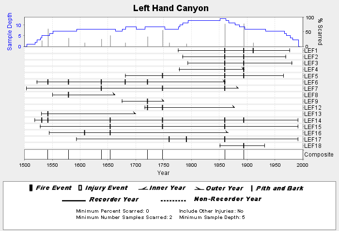
NOAA/WDS Paleoclimatology - Brown fire data from Left Hand Canyon - IMPD USLEF001 recent views
National Oceanic and Atmospheric Administration, Department of Commerce —
This archived Paleoclimatology Study is available from the NOAA National Centers for Environmental Information (NCEI), under the World Data Service (WDS) for... -
Federal
North Carolina 2016 ESI FISH Polygons, Lines recent views
National Oceanic and Atmospheric Administration, Department of Commerce —
This data set contains sensitive biological resource data for marine, estuarine, anadromous, and freshwater fish species in North Carolina. Vector polygons (FISH...

Official websites use .gov
A
.gov website belongs to an official government
organization in the United States.
Secure .gov websites use HTTPS
A
lock (
) or https:// means you’ve safely connected to
the .gov website. Share sensitive information only on official,
secure websites.