
-
Federal
CRED Integrated Benthic Habitat Map for Tutuila Island, American Samoa Year 2007 recent views
National Oceanic and Atmospheric Administration, Department of Commerce —
This is an integrated benthic habitat map system which consists of a number of separate map layers including multibeam bathymetry, digital NOAA nautical charts,... -
Federal
CRED Towed-Diver Benthic Characterization Surveys at Swains Island, American Samoa in 2004 recent views
National Oceanic and Atmospheric Administration, Department of Commerce —
To support NOAA Coral Reef Conservation Program (CRCP) long-term goals for sustainable management and conservation of coral reef ecosystems, towed-diver surveys (aka.... -
Federal
CRED Cumulative Map of Percent Scleractinian Coral Cover at Ofu & Olosega recent views
National Oceanic and Atmospheric Administration, Department of Commerce —
This map displays optical validation observation locations and percent coverage of scleractinian coral overlaid on bathymetry. -
Federal
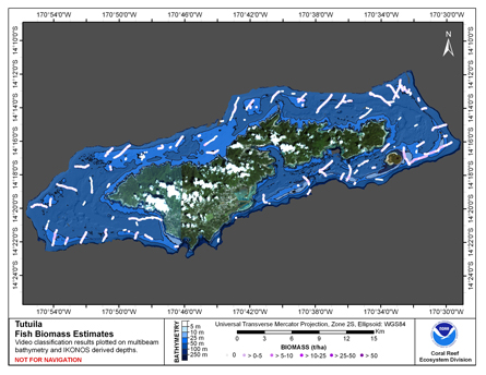
CRED Cumulative Fish Biomass map at Tutuila Island recent views
National Oceanic and Atmospheric Administration, Department of Commerce —
This map displays fish biomass observation locations overlaid on bathymetry. -
Federal
CRED Towed-Diver Benthic Characterization Surveys at Ofu And Olosega Islands, American Samoa in 2004 recent views
National Oceanic and Atmospheric Administration, Department of Commerce —
To support NOAA Coral Reef Conservation Program (CRCP) long-term goals for sustainable management and conservation of coral reef ecosystems, towed-diver surveys (aka.... -
Federal
CRED Towed-Diver Benthic Characterization Surveys at Rose Atoll, American Samoa in 2004 recent views
National Oceanic and Atmospheric Administration, Department of Commerce —
To support NOAA Coral Reef Conservation Program (CRCP) long-term goals for sustainable management and conservation of coral reef ecosystems, towed-diver surveys (aka.... -
Federal
CRED Cumulative Map of Percent Scleractinian Coral Cover at Tutuila recent views
National Oceanic and Atmospheric Administration, Department of Commerce —
This map displays optical validation observation locations and percent coverage of scleractinian coral overlaid on bathymetry. -
Federal
CRED Towed-Diver Benthic Characterization Surveys at Tau Island, American Samoa in 2004 recent views
National Oceanic and Atmospheric Administration, Department of Commerce —
To support NOAA Coral Reef Conservation Program (CRCP) long-term goals for sustainable management and conservation of coral reef ecosystems, towed-diver surveys (aka.... -
Federal
CRED Map of Percent Hard Coral Cover at Tutuila Island, American Samoa recent views
National Oceanic and Atmospheric Administration, Department of Commerce —
This map displays optical validation observation locations and percent coverage of hard coral overlaid on bathymetry. -
Federal
CRED Optical Validation Data at the island of Ta'u in American Samoa, 2004 to Support Benthic Habitat Mapping (TOAD) recent views
National Oceanic and Atmospheric Administration, Department of Commerce —
Optical validation data were collected using a Tethered Optical Assessment Device (TOAD), an underwater sled equipped with an underwater digital video camera and... -
Federal
CRED Towed-Diver Benthic Characterization Surveys at Tutuila Island, American Samoa in 2004 recent views
National Oceanic and Atmospheric Administration, Department of Commerce —
To support NOAA Coral Reef Conservation Program (CRCP) long-term goals for sustainable management and conservation of coral reef ecosystems, towed-diver surveys (aka.... -
Federal
CRED Optical Validation Data at the islands of Ofu and Olosega in American Samoa, 2004 to Support Benthic Habitat Mapping (TOAD) recent views
National Oceanic and Atmospheric Administration, Department of Commerce —
Optical validation data were collected using a Tethered Optical Assessment Device (TOAD), an underwater sled equipped with an underwater digital video camera and... -
Federal
CRED Cumulative Map of Percent Scleractinian Coral Cover at Ta'u recent views
National Oceanic and Atmospheric Administration, Department of Commerce —
This map displays optical validation observation locations and percent coverage of scleractinian coral overlaid on bathymetry.

Official websites use .gov
A
.gov website belongs to an official government
organization in the United States.
Secure .gov websites use HTTPS
A
lock (
) or https:// means you’ve safely connected to
the .gov website. Share sensitive information only on official,
secure websites.