
-
Federal
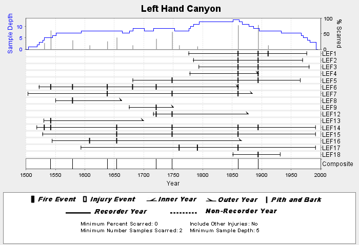
NOAA/WDS Paleoclimatology - Brown fire data from Left Hand Canyon - IMPD USLEF001 recent views
National Oceanic and Atmospheric Administration, Department of Commerce —
This archived Paleoclimatology Study is available from the NOAA National Centers for Environmental Information (NCEI), under the World Data Service (WDS) for... -
Federal
Digital Geologic-GIS Map of Dinosaur National Monument and Vicinity, Colorado and Utah (NPS, GRD, GRI, DINO, DINO digital map) adapted from U.S. Geological Survey Geologic Quadrangle Maps by Hansen, Rowley, Dyni, Cullins, Carrara, Kinney and Pipiringos (1968 to 1991) recent views
Department of the Interior —
The Digital Geologic-GIS Map of Dinosaur National Monument and Vicinity, Colorado and Utah is composed of GIS data layers and GIS tables, and is available in the... -
Federal
2020 Cartographic Boundary File (KML), Current County Subdivision for Colorado, 1:500,000 recent views
U.S. Census Bureau, Department of Commerce —
The 2020 cartographic boundary KMLs are simplified representations of selected geographic areas from the U.S. Census Bureau's Master Address File / Topologically... -
Federal
Unpublished Digital Geologic-GIS Map of Parts of Great Sand Dunes National Park and Preserve (Sangre de Cristo Mountains and part of the Dunes), Colorado (NPS, GRD, GRI, GRSA, GSAM digital map) adapted from U.S. Geological Survey Miscellaneous Field Studies Maps by Lindsey, Johnson, Bruce, Soulliere, Flores and Hafner (1985 to 1991) recent views
Department of the Interior —
The Unpublished Digital Geologic-GIS Map of Parts of Great Sand Dunes National Park and Preserve (Sangre de Cristo Mountains and part of the Dunes), Colorado is... -
Federal
Digital Geologic-GIS Map of the Arriola Quadrangle, Colorado (NPS, GRD, GRI, HOVE, ARRI digital map) adapted from a National Park Service Geologic Resources Inventory geologic map by Poole (2000) recent views
Department of the Interior —
The Digital Geologic-GIS Map of the Arriola Quadrangle, Colorado is composed of GIS data layers and GIS tables, and is available in the following GRI-supported GIS... -
Federal
NOAA/WDS Paleoclimatology - Sherriff fire data from Wild Basin 1 - IMPD USWB1001 recent views
National Oceanic and Atmospheric Administration, Department of Commerce —
This archived Paleoclimatology Study is available from the NOAA National Centers for Environmental Information (NCEI), under the World Data Service (WDS) for... -
Federal
NOAA/WDS Paleoclimatology - Sherriff fire data from Hidden Valley West - IMPD USHV3001 recent views
National Oceanic and Atmospheric Administration, Department of Commerce —
This archived Paleoclimatology Study is available from the NOAA National Centers for Environmental Information (NCEI), under the World Data Service (WDS) for... -
Federal
NOAA/WDS Paleoclimatology - Brown fire data from Manitou Demo Plot - IMPD USMDP001 recent views
National Oceanic and Atmospheric Administration, Department of Commerce —
This archived Paleoclimatology Study is available from the NOAA National Centers for Environmental Information (NCEI), under the World Data Service (WDS) for... -
Federal
2022 Cartographic Boundary File (SHP), Current State Legislative District-Upper Chamber for Colorado, 1:500,000 recent views
U.S. Census Bureau, Department of Commerce —
The 2022 cartographic boundary shapefiles are simplified representations of selected geographic areas from the U.S. Census Bureau's Master Address File /... -
Federal
Identifying and Delineating Thermally Active Areas in Colorado Using Thermal Remote Sensing Data recent views
Department of Energy —
This report outlines the approach and methodology of the utilization of thermal satellite imagery to find areas of warm ground that might indicate heat flow from a... -
Federal
BLM Natl GRSG Existing Sagebrush 2019 recent views
Department of the Interior —
This document summarizes the potential sagebrush vegetation as well as the 2012 - 2019 sagebrush vegetation availability estimates on Greater Sage-Grouse Priority and... -
Federal
2020 Cartographic Boundary File (SHP), Current Census Tract for Colorado, 1:500,000 recent views
U.S. Census Bureau, Department of Commerce —
The 2020 cartographic boundary shapefiles are simplified representations of selected geographic areas from the U.S. Census Bureau's Master Address File /... -
Federal
2020 Cartographic Boundary File (KML), Current State Legislative District-Lower Chamber for Colorado, 1:500,000 recent views
U.S. Census Bureau, Department of Commerce —
The 2020 cartographic boundary KMLs are simplified representations of selected geographic areas from the U.S. Census Bureau's Master Address File / Topologically... -
Federal
Digital Geologic-GIS Map of Black Canyon of the Gunnison River and Vicinity, Colorado (NPS, GRD, GRI, BLCA, CURE, BLCG digital map) adapted from a U.S. Geological Survey Miscellaneous Geologic Investigations Map by Hansen (1971) recent views
Department of the Interior —
The Digital Geologic-GIS Map of Black Canyon of the Gunnison River and Vicinity, Colorado is composed of GIS data layers and GIS tables, and is available in the... -
Federal
Digital Geologic-GIS Map of the Powderhorn Quadrangle, Colorado (NPS, GRD, GRI, CURE, POWD digital map) adapted from a U.S. Geological Survey Geologic Quadrangle Map by Hedlund and Olson (1975) recent views
Department of the Interior —
The Digital Geologic-GIS Map of the Powderhorn Quadrangle, Colorado is composed of GIS data layers and GIS tables, and is available in the following GRI-supported GIS... -
Federal
NOAA/WDS Paleoclimatology - Veblen fire data from BM7 - IMPD USBM-007 recent views
National Oceanic and Atmospheric Administration, Department of Commerce —
This archived Paleoclimatology Study is available from the NOAA National Centers for Environmental Information (NCEI), under the World Data Service (WDS) for... -
Federal
NOAA/WDS Paleoclimatology - Brown fire data from M Kaufmanns Cabin - IMPD USMKC001 recent views
National Oceanic and Atmospheric Administration, Department of Commerce —
This archived Paleoclimatology Study is available from the NOAA National Centers for Environmental Information (NCEI), under the World Data Service (WDS) for... -
Federal
NOAA/WDS Paleoclimatology - Brown fire data from Archuleta Mesa Plot C4 - IMPD USACH019 recent views
National Oceanic and Atmospheric Administration, Department of Commerce —
This archived Paleoclimatology Study is available from the NOAA National Centers for Environmental Information (NCEI), under the World Data Service (WDS) for... -
Federal
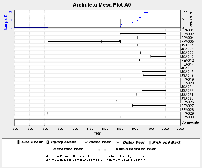
NOAA/WDS Paleoclimatology - Brown fire data from Archuleta Mesa Plot A0 - IMPD USACH001 recent views
National Oceanic and Atmospheric Administration, Department of Commerce —
This archived Paleoclimatology Study is available from the NOAA National Centers for Environmental Information (NCEI), under the World Data Service (WDS) for...

Official websites use .gov
A
.gov website belongs to an official government
organization in the United States.
Secure .gov websites use HTTPS
A
lock (
) or https:// means you’ve safely connected to
the .gov website. Share sensitive information only on official,
secure websites.