

1,108 datasets found for "Geoscience Data"
-
Federal
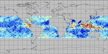
The NOAA NCEI Global Marine Microplastics Database (1972-present) recent views
National Oceanic and Atmospheric Administration, Department of Commerce —
Microplastics (i.e., plastics measuring less than 5mm) pollution is a growing problem affecting coastal communities, marine ecosystems, aquatic life, and human... -
Federal
National Mine Map Repository Mine Locations recent views
Department of the Interior —
The National Mine Map Repository (NMMR) maintains point locations for mines appearing on maps within its archive. This dataset is intended to help connect the Office... -
Federal
USGS National Geologic Map Database Collection NGDA recent views
Department of the Interior —
The National Geologic Map Database (NGMDB) is a Congressionally mandated national archive of geoscience maps, reports, and stratigraphic information. The Geologic... -
Federal
Utah FORGE: Well 78B-32 Daily Drilling Reports and Logs recent views
Department of Energy —
This data set includes the daily drilling reports and Pason data for well 78B-32 and Schlumberger logs acquired after drilling completion. This well was drilled... -
Federal
NCEI Standard Product: World Ocean Database (WOD) recent views
National Oceanic and Atmospheric Administration, Department of Commerce —
The World Ocean Database (WOD) is the world's largest publicly available uniform format quality controlled ocean profile dataset. Ocean profile data are sets of... -
Federal
Utah FORGE: Well 56-32 Drilling Data and Logs recent views
Department of Energy —
This dataset consists of drilling data (Pason data spreadsheets, daily reports, days v. depth, mud logs), Schlumberger logs (FMI, shear anisotropy analysis, memory,... -
Federal
Electrical resistivity tomography (ERT) data recent views
Department of the Interior —
Surface electrical resistivity tomography (ERT), electromagnetic induction (EMI), and self-potential (SP) data were acquired March 9 - 20, 2018 by the U.S. Geological... -
Federal
PoroTomo Natural Laboratory Horizontal and Vertical Distributed Acoustic Sensing Data recent views
Department of Energy —
This dataset includes links to the PoroTomo DAS data in both SEG-Y and hdf5 (via h5py and HSDS with h5pyd) formats with tutorial notebooks for use. Data are hosted on... -
Federal
Shapefiles of faults for the United States, Canada, and Australia recent views
Department of the Interior —
Data presented here include a shapefile that combines fault data for the United States and Canada (Chorlton, 2007; Reed and others, 2005; Styron and Pagani, 2020) and... -
Federal
Utah FORGE: Well 16A(78)-32 Drilling Data recent views
Department of Energy —
This dataset includes survey data, drilling data, daily reports, summaries of daily operations, and rig photos from the drilling of Utah FORGE well 16A(78)-32, which... -
Federal
Biochar 4 Crops recent views
U.S. Environmental Protection Agency —
Raw data files for study of the effects of biochar on growth and elemental content of four crops: carrot, lettuce, soybean and sweetcorn. Plus additional files on... -
Federal
NCCOS Mapping: lakebed maps and associated geospatial data of Wisconsin - Lake Superior, 2020-07-25 to 2022-03-01 (NCEI Accession 0252121) recent views
National Oceanic and Atmospheric Administration, Department of Commerce —
This dataset includes lakebed maps and associated geospatial data in Lake Superior, offshore the Wisconsin Bayfield Peninsula and the Apostle Islands National... -
Federal
Geology shapefiles for the United States and Australia recent views
Department of the Interior —
These data present geologic map units for the United States (Horton and others, 2017; Wilson and others, 2015) and Australia (Raymond and others, 2012) reclassified... -
Federal
Utah FORGE: Updated FMI Fracture Log from Well 16A(78)-32 recent views
Department of Energy —
This dataset consists of an Excel spreadsheet detailing the fracture picks from a reinterpretation of the formation micro-imaging (FMI) log from Utah FORGE well... -
Federal
Utah FORGE: Logs and Data from Deep Well 58-32 (MU-ESW1) recent views
Department of Energy —
Data, logs, and graphics associated with the drilling and testing of Utah FORGE deep test well 58-32 (MU-ESW1) near Roosevelt Hot Springs. -
University
Global Bathymetry and Topography at 15 Arc Sec: SRTM15+V2.0 recent views
OpenTopography —
The global bathymetry and topography grid at 15 Arc Sec is the latest iteration of the SRTM+ digital elevation model (DEM) where the "plus" indicates the addition of... -
Federal
Oil and gas wells data for the Wyoming Landscape Conservation Initiative (WLCI), southwestern Wyoming recent views
Department of the Interior —
This feature class was created to assemble oil and gas well information for a comprehensive inventory of energy data pertinent to the Wyoming Landscape Conservation... -
Federal
Utah FORGE: Earthquake Catalog recent views
Department of Energy —
This is the set of earthquake catalogs developed for the Utah FORGE project covering December of 2016 through March of 2018. These are discussed in the "Utah FORGE... -
Federal
CYGNSS L3 Ocean Microplastic Concentration V1.0 recent views
National Aeronautics and Space Administration —
This dataset contains the version 1.0 CYGNSS level 3 ocean microplastic concentration data record, which provides 18 netCDF files, each containing one month of daily...
1,108 datasets found for "Geoscience Data"