
-
Federal
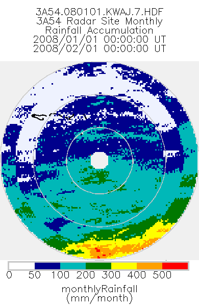
TRMM Ground Validation Radar Site Rain Type Totals Map L3 1 month 2 km V7 (TRMM_3A54UW) at GES DISC
National Aeronautics and Space Administration —
This dataset is part of the University of Washington TRMM Ground Validation products. Monthly rain accumulation cartesian grid based on 2A53UW. Units are mm. Min... -
Federal
Currents, HF Radar, Alaska - North Slope, RTV, Near-Real Time, 2010-present, Hourly, 6km, Lon0360
National Oceanic and Atmospheric Administration, Department of Commerce —
Surface ocean velocities estimated from HF-Radar are representative of the upper 2.4 meters of the ocean. The main objective of near-real time processing is to... -
Federal
Radar - ARL Wind Profilerwith RASS, Boardman - Reviewed Data
Department of Energy —
Overview Wind Profiler with Radio Acoustic Sounding System (RASS) data. Data Quality Automatic quality control (QC) followed by visual manual QC. -
Federal
IceBridge HiCARS 2 L2 Geolocated Ice Thickness V001
National Aeronautics and Space Administration —
This data set contains ice thickness, surface and bed elevation, and echo strength measurements taken over Antarctica using the Hi-Capability Airborne Radar Sounder... -
Federal
SMAP_L1A_RADAR_RECEIVE_ONLY_QA_V001
National Aeronautics and Space Administration —
SMAP Level 1A Radar Receive Only Data Quality Information Version 1 -
Federal
SMAP_L1A_RADAR_RECEIVE_ONLY_QA_V003
National Aeronautics and Space Administration —
SMAP Level 1A Radar Receive Only Data Quality Information Version 3 -
Federal
GPM Ground Validation NEXRAD Level III KDVN IFloodS V1
National Aeronautics and Space Administration —
The GPM Ground Validation NEXRAD Level III KDVN IFloodS dataset contain precipitation products derived from selected NEXt Generation Weather RADar system (NEXRAD)... -
Federal
PDS Cassini Data Release 25
National Aeronautics and Space Administration —
CAPS, CDA, CIRS, HRD, INMS, ISS, MIMI, RADAR, RPWS, RSS, SPICE, UVIS, VIMS -
Federal
Rutgers, Realtime Waves 25mhz LEWE
National Oceanic and Atmospheric Administration, Department of Commerce —
Ocean Wave Heights. Center for Ocean Observing and Leadership, Department of Marine & Coastal Sciences, Rutgers University data from a local source. -
Federal
GPM Ground Validation National Mosaic and Multi-Sensor QPE (NMQ) System IFloodS V1
National Aeronautics and Space Administration —
The GPM Ground Validation National Mosaic and Multi-Sensor QPE (NMQ) System IFloodS dataset contains quality control products, real time rain rate estimates, hourly... -
Federal
Currents, HF Radar, US West Coast, RTV, Near-Real Time, 2012-present, Hourly, 6km
National Oceanic and Atmospheric Administration, Department of Commerce —
Surface ocean velocities estimated from HF-Radar are representative of the upper 2.4 meters of the ocean. The main objective of near-real time processing is to... -
Federal
UGOS-3 - HFR: Isla Contoy, Mexico (ISCY), Measured, Long Range Radial Currents - Real-time
National Oceanic and Atmospheric Administration, Department of Commerce —
Isla Contoy, Mexico(ISCY) - Measured - Long Range Radial Currents. Radial Vectors quality controlled using HFRadarPyPython toolbox -
Federal
SGP97 Surface: DOE ARM Baseline Surface Radiation Network (BSRN) Radiation Data
Department of Agriculture —
The Southern Great Plains 1997 (SGP97) Hydrology Experiment originated from an interdisciplinary investigation, "Soil Moisture Mapping at Satellite Temporal and... -
Federal
Spaceborne Imaging Radar-C Precision
National Aeronautics and Space Administration —
Spaceborne Imaging Radar-C/X-band Synthetic Aperture Radar (SIR-C/X-SAR) is a joint project of the National Aeronautics and Space Administration (NASA), the German... -
Federal
IceBridge HiCARS 2 L1B Time-Tagged Echo Strength Profiles V001
National Aeronautics and Space Administration —
This data set contains Antarctica radar sounder echo strength profiles from the Hi-Capability Radar Sounder (HiCARS) Version 2 instrument. The data were collected by... -
Federal
Marathon, FL (MARA) Long Range Radial Currents
National Oceanic and Atmospheric Administration, Department of Commerce —
Radial Vectors quality controlled using HFRadarPyPython toolbox -
Federal
TRMM Ground Validation Rain Existence L2 1 month V7 (TRMM_2A52) at GES DISC
National Aeronautics and Space Administration —
The TRMM_2A52 product displays the existence of rain in the radar volume scan. 'Existence' is the fraction of the radar FOV which has measurable precipitation. The GV... -
Federal
SMAP_L1B_SIGMA_NAUGHT_LOW_RES_QA_V003
National Aeronautics and Space Administration —
SMAP Level 1B Sigma Naught Low Res Data Quality Info Version 3 -
Federal
GPM Ground Validation NOAA X-band Polarimetric Radar (NOXP) IPHEx V1
National Aeronautics and Space Administration —
The GPM Ground Validation NOAA X-band dual-Polarimetric radar (NOXP) IPHEx dataset consists of differential reflectivity, differential phase shift, co-polar cross... -
Federal
PDS Cassini Data Release 18
National Aeronautics and Space Administration —
CIRS, HRD, ISS, RPWS, RSS, SPICE, UVIS, VIMS

Official websites use .gov
A
.gov website belongs to an official government
organization in the United States.
Secure .gov websites use HTTPS
A
lock (
) or https:// means you’ve safely connected to
the .gov website. Share sensitive information only on official,
secure websites.