
-
Federal
VEMAP 2: Annual Ecosystem Model Responses to U.S. Climate Change, 1994-2100 recent views
National Aeronautics and Space Administration —
Phase 2 of the VEMAP Project developed historical (1895-1993) gridded data sets of climate (temperature, precipitation, solar radiation, humidity, and wind speed) and... -
Federal
GPM IMERG Final Precipitation L3 Half Hourly 0.1 degree x 0.1 degree V07 (GPM_3IMERGHH) at GES DISC recent views
National Aeronautics and Space Administration —
Version 07 is the current version of the data set. Older versions will no longer be available and have been superseded by Version 07. The Integrated Multi-satellitE... -
Federal
TRMM (TMPA) Rainfall Estimate L3 3 hour 0.25 degree x 0.25 degree V7 (TRMM_3B42) at GES DISC recent views
National Aeronautics and Space Administration —
TMPA (3B42) dataset have been discontinued as of Dec. 31, 2019, and users are strongly encouraged to shift to the successor IMERG dataset (doi:... -
Federal
Enhanced MODIS Airborne Simulator (eMAS) L2 Aerosol Data recent views
National Aeronautics and Space Administration —
The Enhanced Moderate Resolution Imaging Spectroradiometer (MODIS) Airborne Simulator (eMAS)instrument is maintained and operated by the Airborne Sensor Facility at... -
Federal
MERRA-2 tavg1_2d_slv_Nx: 2d,1-Hourly,Time-Averaged,Single-Level,Assimilation,Single-Level Diagnostics 0.625 x 0.5 degree V5.12.4 (M2T1NXSLV) at GES DISC recent views
National Aeronautics and Space Administration —
M2T1NXSLV (or tavg1_2d_slv_Nx) is an hourly time-averaged 2-dimensional data collection in Modern-Era Retrospective analysis for Research and Applications version 2... -
Federal
GLDAS Noah Land Surface Model L4 monthly 0.25 x 0.25 degree V2.1 (GLDAS_NOAH025_M) at GES DISC recent views
National Aeronautics and Space Administration —
NASA Global Land Data Assimilation System Version 2 (GLDAS-2) has three components: GLDAS-2.0, GLDAS-2.1, and GLDAS-2.2. GLDAS-2.0 is forced entirely with the... -
Federal
ATom: Merged Atmospheric Chemistry, Trace Gases, and Aerosols recent views
National Aeronautics and Space Administration —
This dataset provides information on greenhouse gases and human-produced air pollution, including atmospheric concentrations of carbon dioxide (CO2), methane (CH4),... -
Federal
GPCP Precipitation Level 3 Daily 0.5-Degree V3.2 (GPCPDAY) at GES DISC recent views
National Aeronautics and Space Administration —
Version 3.2 is the current version. Older versions have been superseded by Version 3.2. The Global Precipitation Climatology Project (GPCP) is the precipitation... -
Federal
MODIS/Terra+Aqua L3 Value-added Aerosol Optical Depth - NRT NGDA recent views
National Aeronautics and Space Administration —
MODIS was launched aboard the Terra satellite on December 18, 1999 (10:30 am equator crossing time) as part of NASA's Earth Observing System (EOS) mission. MODIS with... -
Federal
OMI/Aura Near UV Aerosol Optical Depth and Single Scattering Albedo 1-orbit L2 Swath 13x24 km V004 (OMAERUV) at GES DISC recent views
National Aeronautics and Space Administration —
The Aura Ozone Monitoring Instrument level-2 near UV Aerosol data product OMAERUV (Version 004) is available from the NASA Goddard Earth Sciences Data and Information... -
Federal
GPM IMERG Final Precipitation L3 1 month 0.1 degree x 0.1 degree V07 (GPM_3IMERGM) at GES DISC recent views
National Aeronautics and Space Administration —
Version 07 is the current version of the data set. Older versions will no longer be available and have been superseded by Version 07. The Integrated Multi-satellitE... -
Federal
MERRA-2 inst3_3d_aer_Nv: 3d,3-Hourly,Instantaneous,Model-Level,Assimilation,Aerosol Mixing Ratio 0.625 x 0.5 degree V5.12.4 (M2I3NVAER) at GES DISC recent views
National Aeronautics and Space Administration —
M2I3NVAER (or inst3_3d_aer_Nv) is an instantaneous 3-dimensional 3-hourly data collection in Modern-Era Retrospective analysis for Research and Applications version 2... -
Federal
Global Forest Ecosystem Structure and Function Data For Carbon Balance Research recent views
National Aeronautics and Space Administration —
A comprehensive global database has been assembled to quantify CO2 fluxes and pathways across different levels of integration (from photosynthesis up to net ecosystem... -
Federal
GLDAS Noah Land Surface Model L4 3 hourly 0.25 x 0.25 degree V2.0 (GLDAS_NOAH025_3H) at GES DISC recent views
National Aeronautics and Space Administration —
NASA Global Land Data Assimilation System Version 2 (GLDAS-2) has three components: GLDAS-2.0, GLDAS-2.1, and GLDAS-2.2. GLDAS-2.0 is forced entirely with the... -
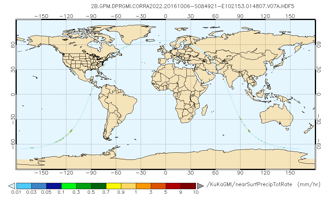
Federal
GPM DPR and GMI Combined Precipitation L2B 1.5 hours 5 km V07 (GPM_2BCMB) at GES DISC recent views
National Aeronautics and Space Administration —
Version 07 is the current version of the data set. Older versions will no longer be available and have been superseded by Version 07. This is a precipitation product... -
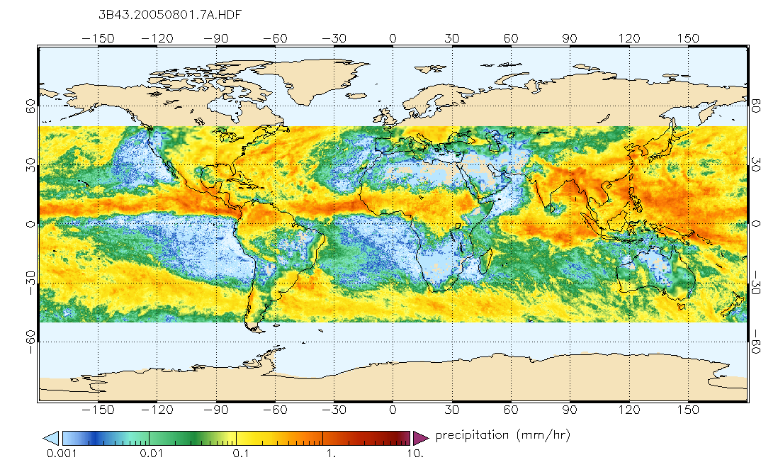
Federal
TRMM (TMPA/3B43) Rainfall Estimate L3 1 month 0.25 degree x 0.25 degree V7 (TRMM_3B43) at GES DISC recent views
National Aeronautics and Space Administration —
TMPA (3B43) dataset have been discontinued as of Dec. 31, 2019, and users are strongly encouraged to shift to the successor IMERG dataset (doi:... -
Federal
TRMM Precipitation Radar Rain Characteristics L2 1.5 hours V7 (TRMM_2A23) at GES DISC recent views
National Aeronautics and Space Administration —
The new version of these data is in GPM-like format (consistent with the GPM Dual-frequency Radar data format), and can be found under the name GPM_2APR. The TRMM... -
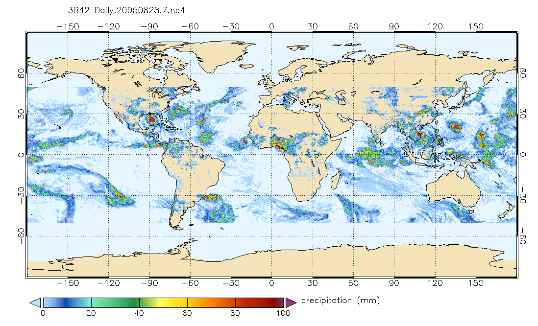
Federal
TRMM (TMPA) Precipitation L3 1 day 0.25 degree x 0.25 degree V7 (TRMM_3B42_Daily) at GES DISC recent views
National Aeronautics and Space Administration —
TMPA (3B42_Daily) dataset have been discontinued as of Dec. 31, 2019, and users are strongly encouraged to shift to the successor IMERG dataset (doi:... -
Federal
Daily and Annual PM2.5, O3, and NO2 Concentrations at ZIP Codes for the Contiguous U.S., 2000-2016, v1.0 recent views
National Aeronautics and Space Administration —
The Daily and Annual PM2.5, O3, and NO2 Concentrations at ZIP Codes for the Contiguous U.S., 2000-2016, v1.0 data set contains daily and annual concentration... -
Federal
GPCP Precipitation Level 3 Monthly 0.5-Degree V3.2 (GPCPMON) at GES DISC recent views
National Aeronautics and Space Administration —
Version 3.2 is the current version. Older versions have been superseded by Version 3.2. The Global Precipitation Climatology Project (GPCP) is the precipitation...

Official websites use .gov
A
.gov website belongs to an official government
organization in the United States.
Secure .gov websites use HTTPS
A
lock (
) or https:// means you’ve safely connected to
the .gov website. Share sensitive information only on official,
secure websites.