

WISE-CASING: Frequency Domain EM Data from Cymric Oil Field, CA
Access & Use Information
Downloads & Resources
-
Cymric Field Data Part 1 at 5 Hz.txtTEXT
Cymric field FEM data from Part 1 using a 5 Hz source frequency. Data is...
-
Cymric Numerical Data Part 1 at 5 Hz.txtTEXT
Cymric field FEM numerical modeling data from Part 1 using a 5 Hz source...
-
Cymric Data Part 1 at 5 Hz - Interpretation.PNGPNG
Field data versus finite element solution for electric field data from Part 1...
-
Cymric Data Part 1 Survey Configuration.PNGPNG
Survey setting from Part 1 shown as a diagram of well 2-8, ground elevation,...
-
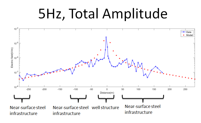
Cymric Field Data Part 2 at 5 Hz.txtTEXT
Cymric field FEM data from Part 2 using a 5 Hz source frequency. Data is...
-
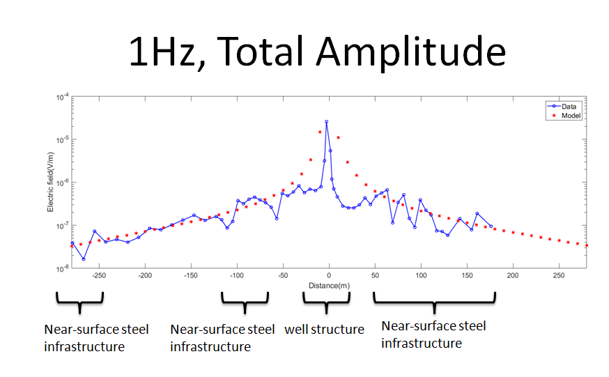
Cymric Field Data Part 2 at 1 Hz.txtTEXT
Cymric field FEM data from Part 2 using a 1 Hz source frequency. Data is...
-
Cymric Modeling Data Part 2 at 5 Hz.solsol
Cymric field numerical modeling data using a 5 Hz source frequency. Data is...
-
Cymric Modeling Data Part 2 at 1 Hz.solsol
Cymric field numerical modeling data using a 1 Hz source frequency. Data is...
-
Cymric Data Part 2 at 1 Hz - Interpretation.PNGPNG
Field data versus finite element solution for electric field data from Part 2...
-
Cymric Data Part 2 at 5 Hz - Interpretation.PNGPNG
Field data versus finite element solution for electric field data from Part 2...
-
Cymric Data Part 2 Survey Configuration.PNGPNG
Survey layout for Part 2, shown as an aerial image with the source and...
-
Landing PageLanding Page
Dates
| Metadata Created Date | January 11, 2025 |
|---|---|
| Metadata Updated Date | January 20, 2025 |
Metadata Source
- Data.json Data.json Metadata
Harvested from OpenEI data.json
Additional Metadata
| Resource Type | Dataset |
|---|---|
| Metadata Created Date | January 11, 2025 |
| Metadata Updated Date | January 20, 2025 |
| Publisher | Lawrence Berkeley National Laboratory |
| Maintainer | |
| Doi | 10.15121/1560530 |
| Identifier | https://data.openei.org/submissions/7306 |
| Data First Published | 2019-04-30T06:00:00Z |
| Data Last Modified | 2020-01-27T22:38:45Z |
| Public Access Level | public |
| Bureau Code | 019:20 |
| Metadata Context | https://openei.org/data.json |
| Metadata Catalog ID | https://openei.org/data.json |
| Schema Version | https://project-open-data.cio.gov/v1.1/schema |
| Catalog Describedby | https://project-open-data.cio.gov/v1.1/schema/catalog.json |
| Data Quality | True |
| Datagov Dedupe Retained | 20250120155001 |
| Harvest Object Id | b4849071-3a59-46c4-a217-61cc0825f3b5 |
| Harvest Source Id | 7cbf9085-0290-4e9f-bec1-91653baeddfd |
| Harvest Source Title | OpenEI data.json |
| Homepage URL | https://gdr.openei.org/submissions/1169 |
| License | https://creativecommons.org/licenses/by/4.0/ |
| Old Spatial | {"type":"Polygon","coordinates":-119.65333720703,35.13361476354,-119.40624599609,35.13361476354,-119.40624599609,35.354789129889,-119.65333720703,35.354789129889,-119.65333720703,35.13361476354} |
| Program Code | 019:006 |
| Projectlead | Mike Weathers |
| Projectnumber | EE0033208 |
| Projecttitle | Wellbore Integrity asSEssment with Casing-based Advanced SenSING (WISE-CASING) |
| Source Datajson Identifier | True |
| Source Hash | dfd73236099eb83cdfea8f74b988eba3e99d4681477d82a21fb70f3ee3be4619 |
| Source Schema Version | 1.1 |
| Spatial | {"type":"Polygon","coordinates":-119.65333720703,35.13361476354,-119.40624599609,35.13361476354,-119.40624599609,35.354789129889,-119.65333720703,35.354789129889,-119.65333720703,35.13361476354} |
Didn't find what you're looking for? Suggest a dataset here.