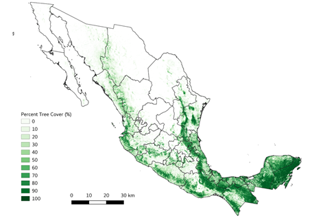
Tree Cover Estimates at 30 m Resolution for Mexico, 2016-2018
Access & Use Information
Downloads & Resources
-
Google Scholar search resultsHTML
Search results for publications that cite this dataset by its DOI.
-
Download this datasetHTML
This link allows direct data access via Earthdata login
-
View documentation related to this datasetHTML
ORNL DAAC Data Set Documentation
-
This dataset's landing pageHTML
Data set Landing Page DOI URL
-
View documentation related to this datasetPDF
Tree Cover Estimates at 30 m Resolution for Mexico, 2016-2018:...
-
Get a related visualizationPNG
Multi-year mean (2016-2018) of percent tree cover maps for Mexico.
-
Landing PageLanding Page
Dates
| Metadata Created Date | May 30, 2023 |
|---|---|
| Metadata Updated Date | December 6, 2023 |
Metadata Source
- Data.json Data.json Metadata
Harvested from NASA Data.json
Other Data Resources
- Geoplatform Metadata Information
Graphic Preview

Additional Metadata
| Resource Type | Dataset |
|---|---|
| Metadata Created Date | May 30, 2023 |
| Metadata Updated Date | December 6, 2023 |
| Publisher | ORNL_DAAC |
| Maintainer | |
| Identifier | C2612824717-ORNL_CLOUD |
| Data First Published | 2023-02-15 |
| Language | en-US |
| Data Last Modified | 2023-06-12 |
| Category | CMS, geospatial |
| Public Access Level | public |
| Bureau Code | 026:00 |
| Metadata Context | https://project-open-data.cio.gov/v1.1/schema/catalog.jsonld |
| Metadata Catalog ID | https://data.nasa.gov/data.json |
| Schema Version | https://project-open-data.cio.gov/v1.1/schema |
| Catalog Describedby | https://project-open-data.cio.gov/v1.1/schema/catalog.json |
| Citation | Park, T., and R. Vargas. 2022. Tree Cover Estimates at 30 m Resolution for Mexico, 2016-2018. ORNL DAAC, Oak Ridge, Tennessee, USA. https://doi.org/10.3334/ORNLDAAC/2137 |
| Graphic Preview Description | Multi-year mean (2016-2018) of percent tree cover maps for Mexico. |
| Graphic Preview File | https://daac.ornl.gov/CMS/guides/Tree_Canopy_Cover_Mexico_Fig1.png |
| Harvest Object Id | 9d96febe-7729-409c-b950-3f25ee117b18 |
| Harvest Source Id | 58f92550-7a01-4f00-b1b2-8dc953bd598f |
| Harvest Source Title | NASA Data.json |
| Homepage URL | https://doi.org/10.3334/ORNLDAAC/2137 |
| Metadata Type | geospatial |
| Old Spatial | -118.4 14.53 -86.7 32.72 |
| Program Code | 026:001 |
| Source Datajson Identifier | True |
| Source Hash | d8b478b508f4b4016226847a4e879702134a70752494df0ee36ce3c4b69f5cae |
| Source Schema Version | 1.1 |
| Spatial | |
| Temporal | 2016-01-01T00:00:00Z/2018-12-31T23:59:59Z |
Didn't find what you're looking for? Suggest a dataset here.


