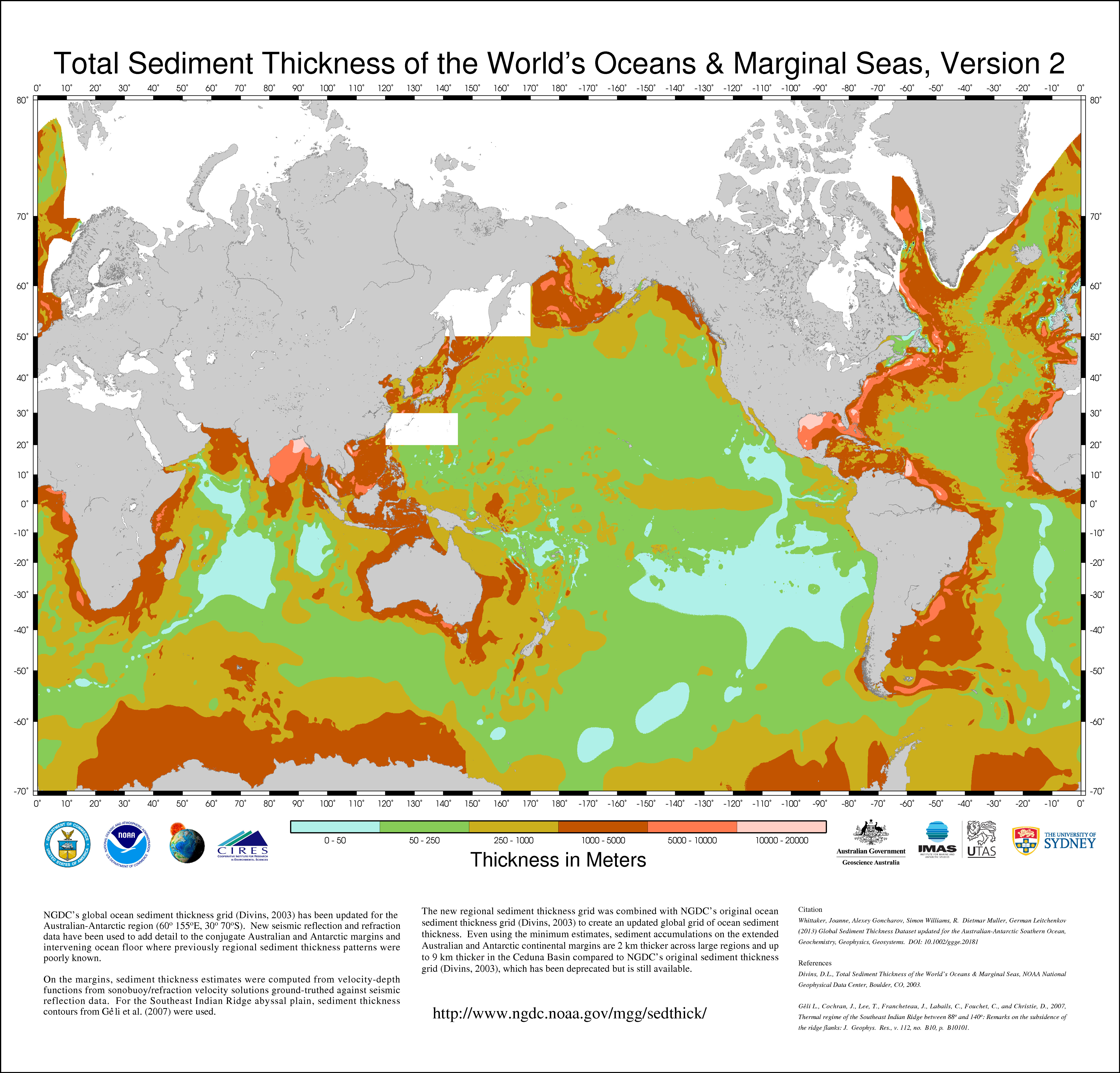
Total Sediment Thickness of the World's Oceans & Marginal Seas, Version 2
Access & Use Information
Downloads & Resources
-
GMT NetCDF grd file
GMT NetCDF grd file
-
geotiffZIP
geotiff
-
ArcGISZIP
ArcGIS
-
ASCII xyzZIP
ASCII xyz
-
Total Sediment Thickness of the World's Oceans...
web access to Total Sediment Thickness of the World's Oceans & Marginal...
-
Global Change Master Directory (GCMD) Keywords
22 views
The information provided on this page seeks to define how the GCMD Keywords...
-
Global Change Master Directory (GCMD) Keywords
22 views
The information provided on this page seeks to define how the GCMD Keywords...
-
Global Change Master Directory (GCMD) Keywords
22 views
The information provided on this page seeks to define how the GCMD Keywords...
-
Geochemistry, Geophysics, Geosystems
Journal article describing the Global sediment thickness dataset updated for...
Dates
| Metadata Date | September 25, 2017 |
|---|---|
| Metadata Created Date | November 12, 2020 |
| Metadata Updated Date | November 12, 2020 |
| Reference Date(s) | May 20, 2013 (publication) |
| Frequency Of Update | asNeeded |
Metadata Source
- ISO-19139 ISO-19139 Metadata
Harvested from NGDC MGG Geophysics
Graphic Preview

Additional Metadata
| Resource Type | Dataset |
|---|---|
| Metadata Date | September 25, 2017 |
| Metadata Created Date | November 12, 2020 |
| Metadata Updated Date | November 12, 2020 |
| Reference Date(s) | May 20, 2013 (publication) |
| Responsible Party | Institute for Marine and Antarctic Studies, University of Tasmania (Point of Contact) |
| Contact Email | |
| Guid | gov.noaa.ngdc.mgg.geophysics:G01065_v2 |
| Access Constraints | Distribution liability: NOAA and NCEI make no warranty, expressed or implied, regarding these data, nor does the fact of distribution constitute such a warranty. NOAA and NCEI cannot assume liability for any damages caused by any errors or omissions in these data. If appropriate, NCEI can only certify that the data it distributes are an authentic copy of the records that were accepted for inclusion in the NCEI archives., Use Constraints: None, Access Constraints: None |
| Bbox East Long | 360 |
| Bbox North Lat | 80.0000 |
| Bbox South Lat | -70.0000 |
| Bbox West Long | 0 |
| Coupled Resource | |
| Frequency Of Update | asNeeded |
| Graphic Preview Description | Image of total sediment thickness of the world's oceans and marginal seas, Version 2 |
| Graphic Preview File | https://www.ngdc.noaa.gov/mgg/image/sedthickv2.png |
| Graphic Preview Type | png |
| Harvest Object Id | 9f27447c-d118-422b-abec-6640e756b124 |
| Harvest Source Id | 80dfcf5d-5e08-457e-83e4-cfc696e378bc |
| Harvest Source Title | NGDC MGG Geophysics |
| Licence | |
| Metadata Language | eng; USA |
| Metadata Type | geospatial |
| Progress | completed |
| Spatial Data Service Type | |
| Spatial Reference System | |
| Spatial Harvester | True |
| Temporal Extent Begin | 2003-12-31 |
| Temporal Extent End | 2013-05-20 |
Didn't find what you're looking for? Suggest a dataset here.

