Sounder SIPS: Suomi NPP ATMS Level 2 RAMSES II: Atmosphere, cloud and surface geophysical state V1 (SNDRSNML2RMS) at GES DISC
Access & Use Information
Downloads & Resources
-
Google Scholar search resultsHTML
Search results for publications that cite this dataset by its DOI.
-
Get a related visualizationPNG
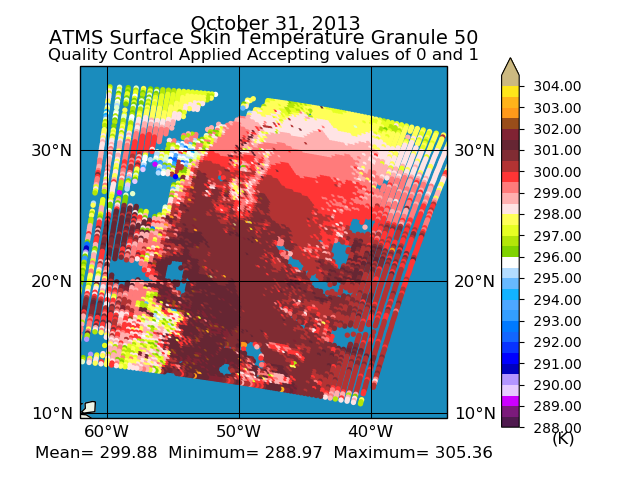
Sample plot of SNPP RAMSES II Level 2 retrieval.
-
This dataset's landing pageHTML
Access the dataset landing page from the GES DISC website.
-
Download this dataset through a directory mapHTML
Access the data via HTTPS.
-
Use OPeNDAP to access the dataset's dataHTML
Access the data via the OPeNDAP protocol.
-
Download this dataset through Earthdata SearchHTML
Search the Earthdata website.
-
View this dataset's read me documentPDF
README Document
-
View this dataset's algorithm theoretical...PDF
ATBD
-
View this dataset's product quality assessmentPDF
Test Report
-
Landing PageLanding Page
References
Dates
| Metadata Created Date | December 1, 2022 |
|---|---|
| Metadata Updated Date | December 6, 2023 |
Metadata Source
- Data.json Data.json Metadata
Harvested from NASA Data.json
Graphic Preview

Additional Metadata
| Resource Type | Dataset |
|---|---|
| Metadata Created Date | December 1, 2022 |
| Metadata Updated Date | December 6, 2023 |
| Publisher | Not provided |
| Maintainer | |
| Identifier | C2099190126-GES_DISC |
| Data First Published | 2013-01-01 |
| Language | en-US |
| Data Last Modified | 2015-11-01 |
| Category | SUOMI-NPP, geospatial |
| Public Access Level | public |
| Bureau Code | 026:00 |
| Metadata Context | https://project-open-data.cio.gov/v1.1/schema/catalog.jsonld |
| Metadata Catalog ID | https://data.nasa.gov/data.json |
| Schema Version | https://project-open-data.cio.gov/v1.1/schema |
| Catalog Describedby | https://project-open-data.cio.gov/v1.1/schema/catalog.json |
| Citation | Bjorn Lambrigtser. 2021-08-04. SNDRSNML2RMS. Version 1. Sounder SIPS: Suomi NPP ATMS Level 2 RAMSES II: Atmosphere, cloud and surface geophysical state V1. Greenbelt, MD, USA. Archived by National Aeronautics and Space Administration, U.S. Government, Goddard Earth Sciences Data and Information Services Center (GES DISC). https://doi.org/10.5067/K9LCXRFH92PC. https://disc.gsfc.nasa.gov/datacollection/SNDRSNML2RMS_1.html. Digital Science Data. |
| Creator | Bjorn Lambrigtser |
| Data Presentation Form | Digital Science Data |
| Graphic Preview Description | Sample plot of SNPP RAMSES II Level 2 retrieval. |
| Graphic Preview File | https://docserver.gesdisc.eosdis.nasa.gov/public/project/Images/SNDRSNML2RMS_01.png |
| Harvest Object Id | a37964e4-cf90-4cb6-96e1-8ef36395cf69 |
| Harvest Source Id | 58f92550-7a01-4f00-b1b2-8dc953bd598f |
| Harvest Source Title | NASA Data.json |
| Homepage URL | https://doi.org/10.5067/K9LCXRFH92PC |
| Metadata Type | geospatial |
| Old Spatial | -180.0 -90.0 180.0 90.0 |
| Program Code | 026:001 |
| Related Documents | https://doi.org/10.1109/TGRS.2012.2220369, https://doi.org/10.1109/JSTARS.2017.2670504, https://doi.org/10.1016/S0022-4073(97)00169-6, https://doi.org/10.1109/TGRS.2002.808236, https://doi.org/10.1029/2005/JD007020 |
| Release Place | Greenbelt, MD, USA |
| Series Name | SNDRSNML2RMS |
| Source Datajson Identifier | True |
| Source Hash | 24469231d2b7cf6761b22f05f11a73820c17574b93bcf356714b9c9e041fc6d8 |
| Source Schema Version | 1.1 |
| Spatial | |
| Temporal | 2013-01-01T00:00:00Z/2015-11-01T23:59:59.999Z |
Didn't find what you're looking for? Suggest a dataset here.

