Sounder SIPS: JPSS-1 CrIS Level 2 CLIMCAPS: Atmosphere cloud and surface geophysical state V2 (SNDRJ1IML2CCPRET) at GES DISC
Access & Use Information
Downloads & Resources
-
Google Scholar search resultsHTML
Search results for publications that cite this dataset by its DOI.
-
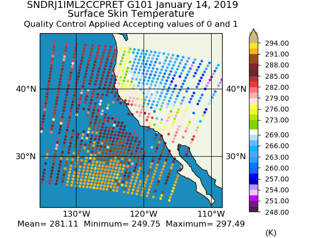
Get a related visualizationPNG
Sample plot of NOAA-20 (JPSS-1) CrIS/ATMS CLIMCAPS Level 2 Retrieval.
-
This dataset's landing pageHTML
Access the dataset landing page from the GES DISC website.
-
Download this dataset through a directory mapHTML
Access the data via HTTPS.
-
Use OPeNDAP to access the dataset's dataHTML
Access the data via the OPeNDAP protocol.
-
Download this dataset through Earthdata SearchHTML
Search the Earthdata website.
-
View this dataset's read me documentPDF
CLIMCAPS L2 Product User Guide:File Format and Definition
-
View this dataset's algorithm theoretical...PDF
CLIMCAPS ATBD
-
View this dataset's product quality assessmentPDF
Product quality assessment guide
-
View this dataset's product usageHTML
CLIMCAPS Science Application Guide (Digital version)
-
View this dataset's product usagePDF
CLIMCAPS Science Application Guide
-
Landing PageLanding Page
References
Dates
| Metadata Created Date | November 12, 2020 |
|---|---|
| Metadata Updated Date | May 6, 2024 |
Metadata Source
- Data.json Data.json Metadata
Harvested from NASA Data.json
Graphic Preview

Additional Metadata
| Resource Type | Dataset |
|---|---|
| Metadata Created Date | November 12, 2020 |
| Metadata Updated Date | May 6, 2024 |
| Publisher | Not provided |
| Maintainer | |
| Identifier | C1692982090-GES_DISC |
| Data First Published | 2018-02-17 |
| Language | en-US |
| Data Last Modified | 2024-04-01 |
| Category | JPSS, geospatial |
| Public Access Level | public |
| Bureau Code | 026:00 |
| Metadata Context | https://project-open-data.cio.gov/v1.1/schema/catalog.jsonld |
| Metadata Catalog ID | https://data.nasa.gov/data.json |
| Schema Version | https://project-open-data.cio.gov/v1.1/schema |
| Catalog Describedby | https://project-open-data.cio.gov/v1.1/schema/catalog.json |
| Citation | Chris Barnet. 2019-12-15. SNDRJ1IML2CCPRET. Version 2. Sounder SIPS: JPSS-1 CrIS Level 2 CLIMCAPS: Atmosphere cloud and surface geophysical state V2. Greenbelt, MD, USA. Archived by National Aeronautics and Space Administration, U.S. Government, Goddard Earth Sciences Data and Information Services Center (GES DISC). https://doi.org/10.5067/LESQUBLWS18H. https://disc.gsfc.nasa.gov/datacollection/SNDRJ1IML2CCPRET_2.html. Digital Science Data. |
| Creator | Chris Barnet |
| Data Presentation Form | Digital Science Data |
| Graphic Preview Description | Sample plot of NOAA-20 (JPSS-1) CrIS/ATMS CLIMCAPS Level 2 Retrieval. |
| Graphic Preview File | https://docserver.gesdisc.eosdis.nasa.gov/public/project/Images/SNDRJ1IML2CCPRET_2.png |
| Harvest Object Id | 34ddc551-19dc-471f-a665-c20e2a829d59 |
| Harvest Source Id | 58f92550-7a01-4f00-b1b2-8dc953bd598f |
| Harvest Source Title | NASA Data.json |
| Homepage URL | https://doi.org/10.5067/LESQUBLWS18H |
| Metadata Type | geospatial |
| Old Spatial | -180.0 -90.0 180.0 90.0 |
| Program Code | 026:001 |
| Related Documents | https://doi.org/10.3390/rs11101227, https://doi.org/10.1109/TGRS.2012.2220369, https://doi.org/10.1109/JSTARS.2017.2670504, https://doi.org/10.1016/S0022-4073(97)00169-6, https://doi.org/10.1109/TGRS.2002.808236, https://doi.org/10.1029/2005/JD007020, https://doi.org/10.5194/amt-13-4437-2020 |
| Release Place | Greenbelt, MD, USA |
| Series Name | SNDRJ1IML2CCPRET |
| Source Datajson Identifier | True |
| Source Hash | f7875dd4cabf589b59416ed271601bde318364268a806aea4b825a3548f5f9c5 |
| Source Schema Version | 1.1 |
| Spatial | |
| Temporal | 2018-02-17T00:00:00Z/2024-05-06T00:00:00Z |
Didn't find what you're looking for? Suggest a dataset here.

