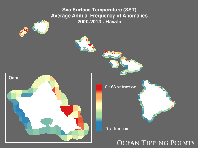
Sea Surface Temperature (SST) Average Annual Frequency of Anomalies, 2000-2013 - Hawaii
Access & Use Information
Downloads & Resources
-
Web Resource
-
Web Resource
-
Web Resource
-
Web Resource
76 views
-
Web Resource
-
Web Resource
-
Web Resource
76 views
-
OGC-WCSWCS
Open Geospatial Consortium Web Coverage Service (WCS). Supported WCS versions...
-
Web Resource
-
Web Resource
76 views
-
OGC-WMSWMS
Open Geospatial Consortium Web Map Service (WMS). Supported WMS versions...
-
Web Resource
-
Web Resource
76 views
-
OGC-WMS-CWMS
38 views
Open Geospatial Consortium Web Map Service - Cached (WMS-C). Use of WMS-C is...
Dates
| Metadata Date | March 30, 2021 |
|---|---|
| Metadata Created Date | November 12, 2020 |
| Metadata Updated Date | October 14, 2022 |
| Reference Date(s) | March 14, 2017 (creation), March 14, 2017 (issued), March 14, 2017 (revision) |
| Frequency Of Update |
Metadata Source
- ISO-19139 ISO-19139 Metadata
Harvested from ioos
Graphic Preview

Additional Metadata
| Resource Type | Dataset |
|---|---|
| Metadata Date | March 30, 2021 |
| Metadata Created Date | November 12, 2020 |
| Metadata Updated Date | October 14, 2022 |
| Reference Date(s) | March 14, 2017 (creation), March 14, 2017 (issued), March 14, 2017 (revision) |
| Responsible Party | National Center for Ecological Analysis and Synthesis (NCEAS) (Point of Contact) |
| Contact Email | |
| Guid | hi_otp_all_sst_anom_freq |
| Access Constraints | |
| Bbox East Long | -154.53930597914805 |
| Bbox North Lat | 22.4237406534364 |
| Bbox South Lat | 18.75414421694241 |
| Bbox West Long | -160.44646121838227 |
| Coupled Resource | [{"title": [], "href": ["#DataIdentification"], "uuid": []}, {"title": [], "href": ["#DataIdentification"], "uuid": []}, {"title": [], "href": ["#DataIdentification"], "uuid": []}] |
| Frequency Of Update | |
| Graphic Preview Description | Sample image. |
| Graphic Preview File | http://pacioos.org/metadata/browse/hi_otp_all_sst_anom_freq.png |
| Harvest Object Id | 2058749c-401e-4b1e-b53d-a7b0ee9eed89 |
| Harvest Source Id | 54e15a6e-6dde-4c9c-a8f0-345cc0dfccfb |
| Harvest Source Title | ioos |
| Licence | |
| Metadata Language | eng |
| Metadata Type | geospatial |
| Old Spatial | {"type": "Polygon", "coordinates": [[[-160.44646121838227, 18.75414421694241], [-154.53930597914805, 18.75414421694241], [-154.53930597914805, 22.4237406534364], [-160.44646121838227, 22.4237406534364], [-160.44646121838227, 18.75414421694241]]]} |
| Progress | |
| Spatial Data Service Type | Open Geospatial Consortium Web Coverage Service (WCS) |
| Spatial Reference System | |
| Spatial Harvester | True |
Didn't find what you're looking for? Suggest a dataset here.

