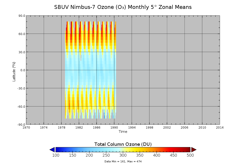
SBUV/Nimbus-7 Ozone (O3) Profile and Total Column Ozone 1 Month Zonal Mean L3 Global 5.0 degree Latitude Zones V1 (SBUVN07L3zm) at GES DISC
Access & Use Information
Downloads & Resources
-
Google Scholar search resultsHTML
Search results for publications that cite this dataset by its DOI.
-
Get a related visualizationPNG
SBUVN07L3zm_1.png
-
This dataset's landing pageHTML
Access the dataset landing page from the GES DISC website.
-
Download this dataset through a directory mapHTML
Access the data via HTTP.
-
Use OPeNDAP to access the dataset's dataHTML
Access the data via the OPeNDAP protocol.
-
Use THREDDS DATA to download the dataset's dataHTML
Access the data using the THREDDS Catalog.
-
View this dataset's read me documentPDF
README Document
-
Landing PageLanding Page
References
| https://doi.org/doi:10.5194/amt-5-2951-2012 |
| https://doi.org/doi:10.5194/amt-6-2533-2013 |
| https://doi.org/doi:10.1002/jgrd.50597 |
Dates
| Metadata Created Date | November 12, 2020 |
|---|---|
| Metadata Updated Date | December 7, 2023 |
Metadata Source
- Data.json Data.json Metadata
Harvested from NASA Data.json
Graphic Preview

Additional Metadata
| Resource Type | Dataset |
|---|---|
| Metadata Created Date | November 12, 2020 |
| Metadata Updated Date | December 7, 2023 |
| Publisher | NASA/GSFC/SED/ESD/GCDC/GESDISC |
| Maintainer | |
| Identifier | C1251051713-GES_DISC |
| Data First Published | 2013-04-22 |
| Language | en-US |
| Data Last Modified | 2013-04-22 |
| Category | MEaSUREs, geospatial |
| Public Access Level | public |
| Bureau Code | 026:00 |
| Metadata Context | https://project-open-data.cio.gov/v1.1/schema/catalog.jsonld |
| Metadata Catalog ID | https://data.nasa.gov/data.json |
| Schema Version | https://project-open-data.cio.gov/v1.1/schema |
| Catalog Describedby | https://project-open-data.cio.gov/v1.1/schema/catalog.json |
| Citation | Richard D. McPeters. 2012-02-15. SBUVN07L3zm. Version 1. SBUV/Nimbus-7 Ozone (O3) Profile and Total Column Ozone 1 Month Zonal Mean L3 Global 5.0 degree Latitude Zones V1. Greenbelt, MD, USA. Archived by National Aeronautics and Space Administration, U.S. Government, Goddard Earth Sciences Data and Information Services Center (GES DISC). https://doi.org/10.5067/MEASURES/OZONE/DATA302. https://disc.gsfc.nasa.gov/datacollection/SBUVN07L3zm_1.html. Digital Science Data. |
| Creator | Richard D. McPeters |
| Data Presentation Form | Digital Science Data |
| Graphic Preview File | https://docserver.gesdisc.eosdis.nasa.gov/public/project/Images/SBUVN07L3zm_1.png |
| Harvest Object Id | 02d41b70-6e10-429d-92b6-de76d69e339b |
| Harvest Source Id | 58f92550-7a01-4f00-b1b2-8dc953bd598f |
| Harvest Source Title | NASA Data.json |
| Homepage URL | https://doi.org/10.5067/MEASURES/OZONE/DATA302 |
| Metadata Type | geospatial |
| Old Spatial | -180.0 -90.0 180.0 90.0 |
| Program Code | 026:001 |
| Related Documents | https://doi.org/doi:10.5194/amt-5-2951-2012, https://doi.org/doi:10.5194/amt-6-2533-2013, https://doi.org/doi:10.1002/jgrd.50597 |
| Release Place | Greenbelt, MD, USA |
| Series Name | SBUVN07L3zm |
| Source Datajson Identifier | True |
| Source Hash | a11210447dfe34a5069177ad6e75c356a989f09c5e8f0042aca657fe2959105a |
| Source Schema Version | 1.1 |
| Spatial | |
| Temporal | 1978-11-01T00:00:00Z/1990-05-31T23:59:59.999Z |
Didn't find what you're looking for? Suggest a dataset here.

