

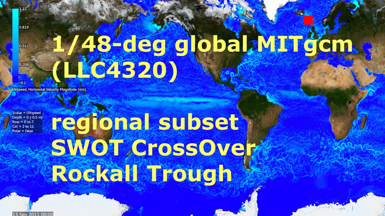
Rockall Trough Pre-SWOT Level-4 Hourly MITgcm LLC4320 Native Grid 2km Oceanographic Dataset Version 1.0
Access & Use Information
Public: This dataset is intended for public access and use.
License: No license information was provided. If this work was prepared by an officer or employee of the United States government as part of that person's official duties it is considered a U.S. Government Work.
Downloads & Resources
-
Data Information (Unknown Format)BIN
-
Data Information (Unknown Format)BIN
-
Data Information (HTML)HTML
-
Data Information (JPEG)JPEG
MITgcm_LLC4320_Pre-SWOT_JPL_L4_RockallTrough_v1.0.jpg
-
Data Information (Unknown Format)BIN
-
Data Information (Unknown Format)BIN
-
Data Information (PDF)PDF
preswot_llc4320_user_guide.pdf
-
Data Information (Unknown Format)BIN
-
Data Information (Unknown Format)BIN
-
Landing PageLanding Page
Dates
| Metadata Created Date | April 11, 2025 |
|---|---|
| Metadata Updated Date | September 18, 2025 |
Metadata Source
- Data.json Data.json Metadata
Harvested from NASA Data.json
Additional Metadata
| Resource Type | Dataset |
|---|---|
| Metadata Created Date | April 11, 2025 |
| Metadata Updated Date | September 18, 2025 |
| Publisher | NASA/JPL/PODAAC |
| Maintainer | |
| Identifier | 10.5067/PRESW-RTJ10 |
| Data Last Modified | 2025-09-11 |
| Category | Earth Science |
| Public Access Level | public |
| Bureau Code | 026:00 |
| Metadata Context | https://project-open-data.cio.gov/v1.1/schema/catalog.jsonld |
| Schema Version | https://project-open-data.cio.gov/v1.1/schema |
| Catalog Describedby | https://project-open-data.cio.gov/v1.1/schema/catalog.json |
| Harvest Object Id | 302bfef0-94df-4e2f-836b-07cd36788304 |
| Harvest Source Id | 58f92550-7a01-4f00-b1b2-8dc953bd598f |
| Harvest Source Title | NASA Data.json |
| Homepage URL | https://podaac.jpl.nasa.gov/SWOT |
| Old Spatial | "CARTESIAN",{"NorthBoundingCoordinate":63.73713,"WestBoundingCoordinate":-12.18558,"EastBoundingCoordinate":-7.320777,"SouthBoundingCoordinate":59.54496}, Maximum Depth;Minimum Depth, 6134.5;0 |
| Program Code | 026:000 |
| Source Datajson Identifier | True |
| Source Hash | 94d6e70603114097cd7c55279fc4ede1b06a4f4d351aef8f6d27f9dd0edcffe2 |
| Source Schema Version | 1.1 |
| Spatial | |
| Temporal | 2011-09-13/2011-09-13 |
Didn't find what you're looking for? Suggest a dataset here.