

OMI/Aura Multi-wavelength Aerosol Optical Depth and Single Scattering Albedo L3 1 day Best Pixel in 0.25 degree x 0.25 degree V3 (OMAEROe) at GES DISC
Access & Use Information
Downloads & Resources
-
Google Scholar search resultsHTML
Search results for publications that cite this dataset by its DOI.
-
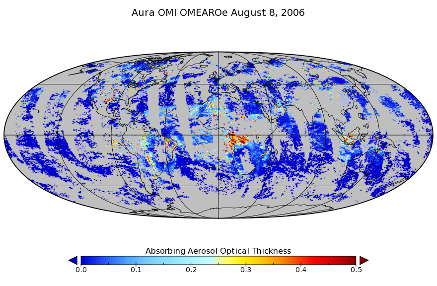
Get a related visualizationPNG
OMAEROe_003.png
-
This dataset's landing pageHTML
Access the dataset landing page from the GES DISC website.
-
Download this dataset through a directory mapHTML
Access the data via HTTPS.
-
Get a related visualization through GIOVANNIHTML
The GES-DISC Interactive Online Visualization ANd aNalysis Interface...
-
Download this dataset through Earthdata SearchHTML
Use the Earthdata Search to find and retrieve data sets across multiple data...
-
Use OPeNDAP to access the dataset's dataHTML
Access the data via the OPeNDAP protocol.
-
View this dataset's read me documentDOC
README Document
-
View this dataset's read me documentPDF
OMI Data User's Guide
-
View the primary investigator's documentation...PDF
File Specification Document
-
The dataset's project home pageHTML
Aura Project Home Page
-
The dataset's project home pageHTML
OMI KNMI Home Page
-
View this dataset's publicationsHTML
-
Use Web Map Service (WMS) to download the...HTML
Get map from GES DISC WMS for AerosolOpticalThicknessMW
-
Use Web Map Service (WMS) to download the...HTML
Get map from GES DISC WMS for AbsorbingAerosolOpticalThicknessMW
-
Use Web Map Service (WMS) to download the...HTML
Get map from GES DISC WMS for SingleScatteringAlbedoMW
-
Use Web Coverage Service (WCS) to download the...HTML
WCS for AbsorbingAerosolOpticalThicknessMW
-
Use Web Coverage Service (WCS) to download the...HTML
WCS for AerosolOpticalThicknessMW
-
Use Web Coverage Service (WCS) to download the...HTML
WCS for SingleScatteringAlbedoMW
-
Landing PageLanding Page
References
| https://doi.org/10.1109/TGRS.2006.869987 |
| https://doi.org/10.1109/TGRS.2006.872935 |
| https://doi.org/10.1117/12.627013 |
Dates
| Metadata Created Date | November 12, 2020 |
|---|---|
| Metadata Updated Date | December 7, 2023 |
Metadata Source
- Data.json Data.json Metadata
Harvested from NASA Data.json
Graphic Preview
Additional Metadata
| Resource Type | Dataset |
|---|---|
| Metadata Created Date | November 12, 2020 |
| Metadata Updated Date | December 7, 2023 |
| Publisher | NASA/GSFC/SED/ESD/GCDC/GESDISC |
| Maintainer | |
| Identifier | C1266136062-GES_DISC |
| Data First Published | 2004-10-01 |
| Language | en-US |
| Data Last Modified | 2012-03-22 |
| Category | Aura, geospatial |
| Public Access Level | public |
| Bureau Code | 026:00 |
| Metadata Context | https://project-open-data.cio.gov/v1.1/schema/catalog.jsonld |
| Metadata Catalog ID | https://data.nasa.gov/data.json |
| Schema Version | https://project-open-data.cio.gov/v1.1/schema |
| Catalog Describedby | https://project-open-data.cio.gov/v1.1/schema/catalog.json |
| Citation | Deborah Stein-Zweers, and Pepijn Veefkind. 2012-03-24. OMAEROe. Version 003. OMI/Aura Multi-wavelength Aerosol Optical Depth and Single Scattering Albedo L3 1 day Best Pixel in 0.25 degree x 0.25 degree V3. NASA Goddard Space Flight Center. Archived by National Aeronautics and Space Administration, U.S. Government, Goddard Earth Sciences Data and Information Services Center (GES DISC). https://doi.org/10.5067/Aura/OMI/DATA3004. https://disc.gsfc.nasa.gov/datacollection/OMAEROe_003.html. Digital Science Data. |
| Creator | Deborah Stein-Zweers, and Pepijn Veefkind |
| Data Presentation Form | Digital Science Data |
| Graphic Preview Description | The GES-DISC Interactive Online Visualization ANd aNalysis Interface (Giovanni) is a web-based tool that allows users to interactively visualize and analyze data. |
| Graphic Preview File | https://giovanni.gsfc.nasa.gov/giovanni/#dataKeyword=OMAEROe |
| Harvest Object Id | 3cd0c196-c521-4ca9-b57f-2d497dc4fda6 |
| Harvest Source Id | 58f92550-7a01-4f00-b1b2-8dc953bd598f |
| Harvest Source Title | NASA Data.json |
| Homepage URL | https://doi.org/10.5067/Aura/OMI/DATA3004 |
| Metadata Type | geospatial |
| Old Spatial | -180.0 -90.0 180.0 90.0 |
| Program Code | 026:001 |
| Related Documents | https://doi.org/10.1109/TGRS.2006.869987, https://doi.org/10.1109/TGRS.2006.872935, https://doi.org/10.1117/12.627013 |
| Release Place | NASA Goddard Space Flight Center |
| Series Name | OMAEROe |
| Source Datajson Identifier | True |
| Source Hash | 10627a2b1358e5d78d49af9bd8e235617e189f89b120499f3d306b5a9a3ce4f0 |
| Source Schema Version | 1.1 |
| Spatial | |
| Temporal | 2004-10-01T00:00:00Z/2022-01-17T00:00:00Z |
Didn't find what you're looking for? Suggest a dataset here.