NOAA and MMS Marine Minerals Geochemical Database
Access & Use Information
Downloads & Resources
-
Metadata Landing Page
How to cite this data set (doi:10.7289/V52Z13FT), all access options, and...
-
Data files and documentation
Selected data files in the MMDB format, format documentation, and project...
-
Web pageHTML
Web page of information about the NOAA and MMS Marine Minerals Project.
-
CD-ROM Ordering informationHTML
Web page of information about the CD-ROM product with links to order from the...
-
NCEI Contact Information
Information for contacts at NCEI.
-
GCMD Keyword Forum Page
Global Change Master Directory (GCMD). 2024. GCMD Keywords, Version 19....
-
Library of Congress Subject Headings (LCSH)
The Library of Congress Subject Headings (LCSH) are part of a Linked Data...
-
SeaDataNet Common Vocabularies
The SeaDataNet Vocabulary Server is populated with lists describing a wide...
-
USGS Thesaurus
The USGS Thesaurus contains thematic terms for categorizing information...
-
GCMD Keyword Forum Page
Global Change Master Directory (GCMD). 2024. GCMD Keywords, Version 19....
-
GCMD Keyword Forum Page
Global Change Master Directory (GCMD). 2024. GCMD Keywords, Version 19....
-
GCMD Keyword Forum Page
Global Change Master Directory (GCMD). 2024. GCMD Keywords, Version 19....
-
GCMD Keyword Forum Page
Global Change Master Directory (GCMD). 2024. GCMD Keywords, Version 19....
-
GCMD Keyword Forum Page
Global Change Master Directory (GCMD). 2024. GCMD Keywords, Version 19....
-
doi:10.7289/V53X84KN
This data set contains related data and information.
-
doi:10.13140/RG.2.1.2297.0403
This data set contains related data and information.
-
Parent Archive
Information about the Marine Geology Data Archive at NCEI.
-
Marine geology metadata records.
Dates
| Metadata Date | April 21, 2020 |
|---|---|
| Metadata Created Date | October 18, 2024 |
| Metadata Updated Date | October 18, 2024 |
| Reference Date(s) | October 31, 1991 (publication), October 31, 1991 (revision) |
| Frequency Of Update | notPlanned |
Metadata Source
- ISO-19139 ISO-19139 Metadata
Harvested from NGDC MGG Geology
Graphic Preview

Additional Metadata
| Resource Type | Dataset |
|---|---|
| Metadata Date | April 21, 2020 |
| Metadata Created Date | October 18, 2024 |
| Metadata Updated Date | October 18, 2024 |
| Reference Date(s) | October 31, 1991 (publication), October 31, 1991 (revision) |
| Responsible Party | NOAA National Centers for Environmental Information (Point of Contact) |
| Contact Email | |
| Guid | gov.noaa.ngdc.mgg.geology:G01323 |
| Access Constraints | Distribution liability: NOAA and NCEI make no warranty, expressed or implied, regarding these data, nor does the fact of distribution constitute such a warranty. NOAA and NCEI cannot assume liability for any damages caused by any errors or omissions in these data. If appropriate, NCEI can only certify that the data it distributes are an authentic copy of the records that were accepted for inclusion in the NCEI archives., Use liability: NOAA and NCEI cannot provide any warranty as to the accuracy, reliability, or completeness of furnished data. Users assume responsibility to determine the usability of these data. The user is responsible for the results of any application of this data for other than its intended purpose., Cite as: Grant, J. Bruce; Moore, Carla J.; Alameddin, George; Chen, Kuiying and Mark Barton. 1991: NOAA and MMS Marine Minerals Geochemical Database. First. NOAA National Centers for Environmental Information. https://doi.org/10.7289/V52Z13FT. Accessed [date]., Access to this dataset is unrestricted, however no search/subset capabilities are provided by NCEI., While every effort has been made to ensure that these data are accurate and reliable within the limits of the current state of the art, NOAA cannot assume liability for any damages caused by any errors or omissions in the data, nor as a result of the failure of the data to function on a particular system. NOAA makes no warranty, expressed or implied, nor does the fact of distribution constitute such a warranty. |
| Bbox East Long | 180 |
| Bbox North Lat | 90 |
| Bbox South Lat | -90 |
| Bbox West Long | -180 |
| Coupled Resource | |
| Frequency Of Update | notPlanned |
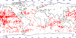
| Graphic Preview Description | sample locations in study area |
| Graphic Preview File | https://www.ngdc.noaa.gov/mgg/image/geolin/preview03995011.gif |
| Graphic Preview Type | GIF |
| Harvest Object Id | 0dce46a2-ef15-44e3-a4ea-596a3938b2e2 |
| Harvest Source Id | 2738981c-0c63-4286-9da7-20abe8cd4700 |
| Harvest Source Title | NGDC MGG Geology |
| Licence | Produced by the NOAA National Centers for Environmental Information. Not subject to copyright protection within the United States. |
| Lineage | The NOAA and MMS Marine Minerals CD-ROM data set was compiled from multiple sources contributed in digital form and also from key entry by students at NGDC of geochemical data from the literature. |
| Metadata Language | |
| Metadata Type | geospatial |
| Old Spatial | {"type": "Polygon", "coordinates": [[[-180.0, -90.0], [180.0, -90.0], [180.0, 90.0], [-180.0, 90.0], [-180.0, -90.0]]]} |
| Progress | completed |
| Spatial Data Service Type | |
| Spatial Reference System | urn:ogc:def:crs:EPSG:4326 |
| Spatial Harvester | True |
| Temporal Extent Begin | 1984-05-02 |
| Temporal Extent End | 1991-10-31 |
Didn't find what you're looking for? Suggest a dataset here.

