

NAMMA LIDAR ATMOSPHERIC SENSING EXPERIMENT (LASE) V1
Access & Use Information
Downloads & Resources
-
Google Scholar search resultsHTML
Search results for publications that cite this dataset by its DOI.
-
Download this datasetHTML
Files may be downloaded directly to your workstation from this link
-
Get a related visualizationGIF
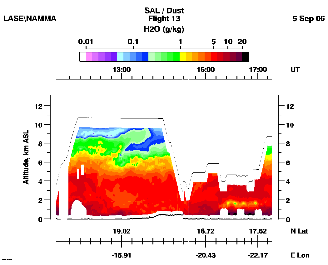
Sample browse image
-
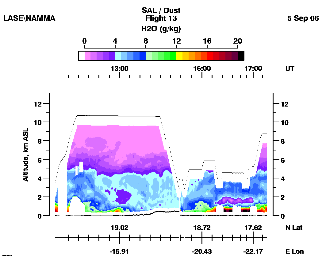
Get a related visualizationGIF
Sample browse image
-
Get a related visualizationGIF
Sample browse image
-
View documentation related to this datasetHTML
The guide document contains detailed information about the dataset
-
View the primary investigator's documentation...PDF
Format Specication for Data Exchange
-
View the primary investigator's documentation...HTML
Code to demonstrate reading LASE SOLVE/AFWEX data files
-
The dataset's project home pageHTML
The home page for the project or program which sponsored the dataset
-
View a micro article on this datasetHTML
Hurricane Micro Article
-
Get a related visualizationHTML
N/A
-
View documentation related to this datasetHTML
Instructions for citing GHRC data
-
Landing PageLanding Page
Dates
| Metadata Created Date | December 1, 2022 |
|---|---|
| Metadata Updated Date | December 7, 2023 |
Metadata Source
- Data.json Data.json Metadata
Harvested from NASA Data.json
Graphic Preview
Additional Metadata
| Resource Type | Dataset |
|---|---|
| Metadata Created Date | December 1, 2022 |
| Metadata Updated Date | December 7, 2023 |
| Publisher | NASA/MSFC/GHRC |
| Maintainer | |
| Identifier | C1979887067-GHRC_DAAC |
| Data First Published | 2006-06-01 |
| Language | en-US |
| Data Last Modified | 2022-05-19 |
| Category | NAMMA, geospatial |
| Public Access Level | public |
| Bureau Code | 026:00 |
| Metadata Context | https://project-open-data.cio.gov/v1.1/schema/catalog.jsonld |
| Metadata Catalog ID | https://data.nasa.gov/data.json |
| Schema Version | https://project-open-data.cio.gov/v1.1/schema |
| Catalog Describedby | https://project-open-data.cio.gov/v1.1/schema/catalog.json |
| Citation | Browell, Edward V, Syed Ismail, Richard A Ferrare, Susan Kooi, Anthony Notari, Carolyn Butler, Sharon Burton and Marta Fenn.2006. NAMMA LIDAR ATMOSPHERIC SENSING EXPERIMENT (LASE) indicate subset used. Dataset available online from the NASA Global Hydrometeorology Resource Center DAAC, Huntsville, Alabama, U.S.A. DOI: http://dx.doi.org/10.5067/NAMMA/LASE/DATA201 |
| Graphic Preview Description | N/A |
| Graphic Preview File | https://ghrc.nsstc.nasa.gov/pub/fieldCampaigns/namma/LASE/browse/ |
| Harvest Object Id | a8ce183e-4812-491e-a2d6-e3096e59269e |
| Harvest Source Id | 58f92550-7a01-4f00-b1b2-8dc953bd598f |
| Harvest Source Title | NASA Data.json |
| Homepage URL | https://doi.org/10.5067/NAMMA/LASE/DATA201 |
| Metadata Type | geospatial |
| Old Spatial | -96.5259 7.0367 -10.5579 47.8839 |
| Program Code | 026:001 |
| Source Datajson Identifier | True |
| Source Hash | f02a265fa9527b03c20454b04f460cadd7f057ebb51a4114d04a85ba8193bcee |
| Source Schema Version | 1.1 |
| Spatial | |
| Temporal | 2006-08-15T03:25:21Z/2006-09-12T19:07:37Z |
Didn't find what you're looking for? Suggest a dataset here.