Multibeam Bathymetry Database (MBBDB)
Access & Use Information
Downloads & Resources
-
Multibeam BathymetryHTML
Information about and access to multibeam bathymetric data at NCEI
-
Bathymetric Data Viewer
Map viewer for discovery of bathymetric data - including multibeam sonar data
-
NCEI Contact Information
15 views
Information for contacts at NCEI.
-
Global Change Master Directory (GCMD) Keywords
The information provided on this page seeks to define how the GCMD Keywords...
-
Global Change Master Directory (GCMD) Keywords
The information provided on this page seeks to define how the GCMD Keywords...
-
Global Change Master Directory (GCMD) Keywords
The information provided on this page seeks to define how the GCMD Keywords...
-
Global Change Master Directory (GCMD) Keywords
The information provided on this page seeks to define how the GCMD Keywords...
-
Global Change Master Directory (GCMD) Keywords
The information provided on this page seeks to define how the GCMD Keywords...
-
Multibeam Bathymetric Data at NCEIHTML
Please see website for more information about Multibeam Bathymetric Data. Test
-
NOAA GeoPlatform Entry for Multibeam...
NOAA GeoPlatform listing for Multibeam Bathymetric Surveys map service.
-
Global Change Master Directory (GCMD) Keywords
The information provided on this page seeks to define how the GCMD Keywords...
-
Multibeam Bathymetric Surveys ArcGIS Hosted Tile LayerEsri REST
The Multibeam Bathymetric Surveys ArcGIS hosted tile layer provides rapid...
-
Multibeam Bathymetric Surveys ArcGIS Dynamic...Esri REST
The Multibeam Bathymetric Surveys ArcGIS dynamic map service is visible at...
-
Multibeam Bathymetric Surveys Web Map Service (WMS)WMS
Capabilities document for Open Geospatial Consortium Web Map Service for...
Dates
| Metadata Date | September 15, 2023 |
|---|---|
| Metadata Created Date | September 16, 2023 |
| Metadata Updated Date | October 11, 2023 |
| Reference Date(s) | 1980 (creation), 2023 (revision), September 15, 2023 (publication) |
| Frequency Of Update | asNeeded |
Metadata Source
- ISO-19139 ISO-19139 Metadata
Harvested from NGDC Collection
Graphic Preview

Additional Metadata
| Resource Type | Series |
|---|---|
| Metadata Date | September 15, 2023 |
| Metadata Created Date | September 16, 2023 |
| Metadata Updated Date | October 11, 2023 |
| Reference Date(s) | 1980 (creation), 2023 (revision), September 15, 2023 (publication) |
| Responsible Party | NOAA National Centers for Environmental Information (Point of Contact) |
| Contact Email | |
| Guid | gov.noaa.ngdc:G01034 |
| Category Tag 16E15F51 D96E 4051 9124 75665Abdc6Ff | ["Arctic Ocean, Sea Ice and Coasts","Permafrost and Arctic Landscapes","Arctic","Coastal Flooding","Elevation and Bathymetry"] |
| Access Constraints | Distribution liability: NOAA and NCEI make no warranty, expressed or implied, regarding these data, nor does the fact of distribution constitute such a warranty. NOAA and NCEI cannot assume liability for any damages caused by any errors or omissions in these data. If appropriate, NCEI can only certify that the data it distributes are an authentic copy of the records that were accepted for inclusion in the NCEI archives., Use liability: NOAA and NCEI cannot provide any warranty as to the accuracy, reliability, or completeness of furnished data. Users assume responsibility to determine the usability of these data. The user is responsible for the results of any application of this data for other than its intended purpose., Cite as: NOAA National Centers for Environmental Information. 2004: Multibeam Bathymetry Database (MBBDB). [cruise]. NOAA National Centers for Environmental Information. https://doi.org/doi:10.7289/V56T0JNC. Accessed [date]., Data shall NOT be used for navigation. Nautical charts produced and certified by NOAA should be used for navigational purposes. For more information on NOAA's nautical charts go to NOAA's Office of Coast Survey website., Data are publicly available and free to use. |
| Bbox East Long | 180 |
| Bbox North Lat | 90 |
| Bbox South Lat | -90 |
| Bbox West Long | -180 |
| Coupled Resource | |
| Frequency Of Update | asNeeded |
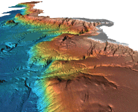
| Graphic Preview Description | 1996: Dr. Lincoln Pratson, INSTAAR/NGDC offshore California gridded multibeam data |
| Graphic Preview File | https://ngdc.noaa.gov/mgg/image/multibeam.gif |
| Graphic Preview Type | gif |
| Harvest Object Id | 2bcce5c7-94a4-403d-acf2-7877b331d10f |
| Harvest Source Id | 5088829e-ee94-4daf-8d22-e38f5358f506 |
| Harvest Source Title | NGDC Collection |
| Licence | None, None |
| Lineage | |
| Metadata Language | |
| Metadata Type | geospatial |
| Old Spatial | {"type": "Polygon", "coordinates": [[[-180.0, -90.0], [180.0, -90.0], [180.0, 90.0], [-180.0, 90.0], [-180.0, -90.0]]]} |
| Progress | inProgress |
| Spatial Data Service Type | ArcGIS Map Service |
| Spatial Reference System | Through the collection reference systems have vaired with time and location. Please see survey level metadata for detailed information. |
| Spatial Harvester | True |
| Temporal Extent Begin | 1980-01-01 |
Didn't find what you're looking for? Suggest a dataset here.

