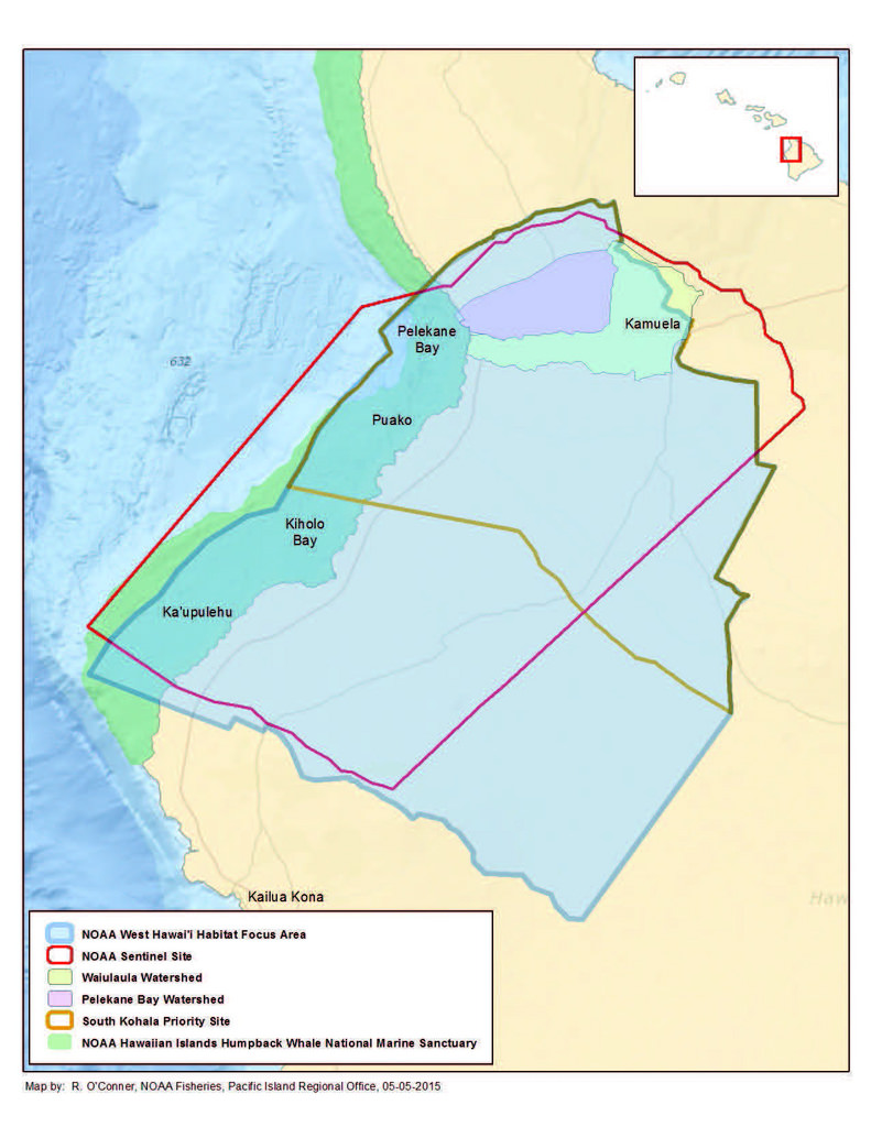
Hard and Soft Bottom Seafloor Substrate Map Derived from an Unsupervised Classification of Gridded Bathymetry Derivatives for the NOAA Habitat Blueprint West Hawaii Focus Area
Access & Use Information
Downloads & Resources
-
WestHawaii_hardsoft.zipZIP
Zip file containing hard- and soft-bottom substrates data (shapefile feature...
-
Full Metadata Record
View the complete metadata record on InPort for more information about this...
-
NOAA Coral Reef Conservation Program Website
Link to the NOAA Coral Reef Conservation Program website
-
Pacific Islands Fisheries Science Center Website
Pacific Island Fisheries Science Center homepage
-
Citation URL
NOAA Habitat Blueprint West Hawaii Focus Area website
-
Citation URLHTML
Pacific Islands Benthic Habitat Mapping Center (PIBHMC) website. All data are...
-
Global Change Master Directory (GCMD) Keywords
11 views
The information provided on this page seeks to define how the GCMD Keywords...
-
NOAA Data Management Plan (DMP)PDF
NOAA Data Management Plan for this record on InPort.
Dates
| Metadata Date | February 29, 2024 |
|---|---|
| Metadata Created Date | November 12, 2020 |
| Metadata Updated Date | March 16, 2024 |
| Reference Date(s) | 2016 (publication) |
| Frequency Of Update | notPlanned |
Metadata Source
- ISO-19139 ISO-19139 Metadata
Harvested from NMFS PIFSC
Graphic Preview

Additional Metadata
| Resource Type | Dataset |
|---|---|
| Metadata Date | February 29, 2024 |
| Metadata Created Date | November 12, 2020 |
| Metadata Updated Date | March 16, 2024 |
| Reference Date(s) | 2016 (publication) |
| Responsible Party | (Point of Contact, Custodian) |
| Contact Email | |
| Guid | gov.noaa.nmfs.inport:12618 |
| Access Constraints | Cite As: Pacific Islands Fisheries Science Center, [Date of Access]: Hard and Soft Bottom Seafloor Substrate Map Derived from an Unsupervised Classification of Gridded Bathymetry Derivatives for the NOAA Habitat Blueprint West Hawaii Focus Area [Data Date Range], https://www.fisheries.noaa.gov/inport/item/12618., Access Constraints: None, Use Constraints: These data are not to be used for navigation purposes. Please cite NOAA Coral Reef Ecosystem Program (CREP) when using the data. Suggested citation: Coral Reef Ecosystem Program; Pacific Islands Fisheries Science Center (2016). Hard and Soft Bottom Seafloor Substrate Map Derived from an Unsupervised Classification of Gridded Bathymetry Derivatives for the NOAA Habitat Blueprint West Hawaii Focus Area. https://www.fisheries.noaa.gov/inport/item/12618 [access date], Distribution Liability: While every effort has been made to ensure that these data are accurate and reliable within the limits of the current state of the art, NOAA cannot assume liability for any damages caused by errors or omissions in the data, nor as a result of the failure of the data to function on a particular system. NOAA makes no warranty, expressed or implied, nor does the fact of distribution constitute such a warranty. |
| Bbox East Long | -155.822838 |
| Bbox North Lat | 20.061727 |
| Bbox South Lat | 19.772429 |
| Bbox West Long | -156.100504 |
| Coupled Resource | |
| Frequency Of Update | notPlanned |
| Graphic Preview Description | NOAA Habitat Blueprint West Hawaii Focus Area |
| Graphic Preview File | https://www.habitatblueprint.noaa.gov/storymap/hfa/hfa_pages/images/westHawaii/location_map.jpg |
| Graphic Preview Type | JPG |
| Harvest Object Id | ca4dc7be-50be-44df-a4ff-be7299221d22 |
| Harvest Source Id | c0beac72-5f43-4455-8c33-1b345fbc2dfe |
| Harvest Source Title | NMFS PIFSC |
| Licence | NOAA provides no warranty, nor accepts any liability occurring from any incomplete, incorrect, or misleading data, or from any incorrect, incomplete, or misleading use of the data. It is the responsibility of the user to determine whether or not the data is suitable for the intended purpose. |
| Lineage | The Iso Cluster Unsupervised Classification tool in ArcGIS was used to classify the three-band Principle Component Analysis image into two distinct hard vs soft substrate classes. Ground truth optical imagery as well as existing shallow water habitat maps provided by the USGS and NOAA Biogeography Branch were used to validate and correct the hard soft classification. |
| Metadata Language | eng |
| Metadata Type | geospatial |
| Old Spatial | {"type": "Polygon", "coordinates": [[[-156.100504, 19.772429], [-155.822838, 19.772429], [-155.822838, 20.061727], [-156.100504, 20.061727], [-156.100504, 19.772429]]]} |
| Progress | completed |
| Spatial Data Service Type | |
| Spatial Reference System | |
| Spatial Harvester | True |
| Temporal Extent Begin | 2006 |
| Temporal Extent End | 2014 |
Didn't find what you're looking for? Suggest a dataset here.

