

DISCOVER-AQ California Deployment Analysis and Ancillary Ground Site Data
Access & Use Information
Public: This dataset is intended for public access and use.
License: No license information was provided. If this work was prepared by an officer or employee of the United States government as part of that person's official duties it is considered a U.S. Government Work.
Downloads & Resources
-
Data Information (Unknown Format)BIN
-
Data Information (HTML)HTML
-
Data Information (ZIP)ZIP
DeltaX_UAVSAR_L3_ChannelMap_V2_2344.zip
-
Data Information (JPEG)JPEG
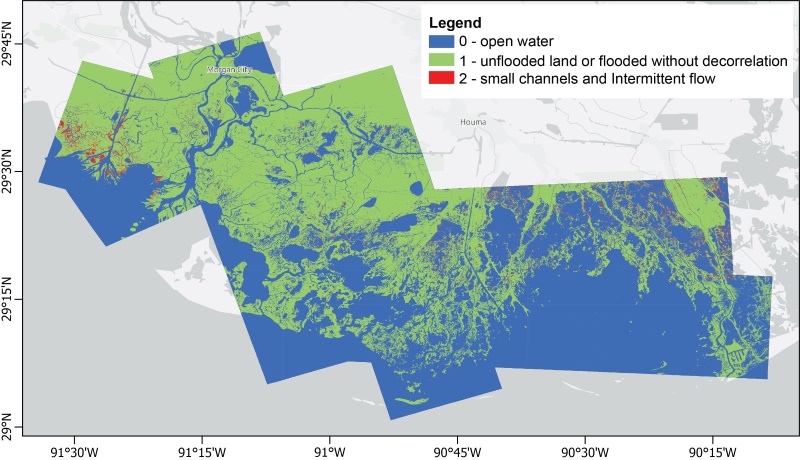
DeltaX_UAVSAR_L3_ChannelMap_V2_Fig1.jpg
-
Data Information (Unknown Format)BIN
-
Data Information (PDF)PDF
DeltaX_UAVSAR_L3_ChannelMap_V2.pdf
-
Landing PageLanding Page
Dates
| Metadata Created Date | April 9, 2025 |
|---|---|
| Metadata Updated Date | November 14, 2025 |
Metadata Source
- Data.json Data.json Metadata
Harvested from NASA Data.json
Additional Metadata
| Resource Type | Dataset |
|---|---|
| Metadata Created Date | April 9, 2025 |
| Metadata Updated Date | November 14, 2025 |
| Publisher | NASA/LARC/SD/ASDC |
| Maintainer | |
| Identifier | 10.5067/ASDC/SUBORBITAL/DISCOVERAQ_California_Ground_Analysis_Ancillary_Data_1 |
| Data Last Modified | 2025-09-11 |
| Category | Earth Science |
| Public Access Level | public |
| Bureau Code | 026:00 |
| Metadata Context | https://project-open-data.cio.gov/v1.1/schema/catalog.jsonld |
| Schema Version | https://project-open-data.cio.gov/v1.1/schema |
| Catalog Describedby | https://project-open-data.cio.gov/v1.1/schema/catalog.json |
| Harvest Object Id | 55dd20f4-ff05-49fd-aa25-e75561e7e646 |
| Harvest Source Id | 58f92550-7a01-4f00-b1b2-8dc953bd598f |
| Harvest Source Title | NASA Data.json |
| Homepage URL | https://asdc.larc.nasa.gov/citing-data |
| Old Spatial | "CARTESIAN",{"Boundary":{"Points":{"Latitude":25,"Longitude":-130},{"Latitude":25,"Longitude":-70},{"Latitude":45,"Longitude":-70},{"Latitude":45,"Longitude":-130},{"Latitude":25,"Longitude":-130}}}, Maximum Altitude, 200 m |
| Program Code | 026:000 |
| Source Datajson Identifier | True |
| Source Hash | 7b1677ffaedf09e42171a972abeef615496a3b77cdd32474748417196cef03cf |
| Source Schema Version | 1.1 |
| Spatial | |
| Temporal | 2013-01-14/2013-01-14 |
Didn't find what you're looking for? Suggest a dataset here.