Determining Watershed Management Efficacy in West Maui: line-point-intercept and photo quadrat surveys of benthic communities for benthic cover from 2014 to 2015
Access & Use Information
Downloads & Resources
-
V0_BENT_LPI Maui 2014-2015.csv
Benthic category data from line-point-intercept surveys conducted by the NOAA...
-
Full Metadata Record
View the complete metadata record on InPort for more information about this...
-
Pacific Islands Fisheries Science Center Website
Pacific Island Fisheries Science Center homepage
-
Citation URL
NOAA Coral Reef Ecosystem Program (CREP) Ecological Assessment of Coral...
-
Citation URLPDF
Wahikuli-Honokowai Watershed Management Plan Volume 1: Watershed...
-
Citation URLPDF
Wahikuli-Honokowai Watershed Management Plan Volume 2: Executive Summary
-
Citation URLPDF
Wahikuli-Honokowai Watershed Management Plan Volume 2: Strategies and...
-
Citation URLPDF
Wahikuli-Honokowai Watershed Management Plan Volume1: Executive Summary
-
Global Change Master Directory (GCMD) Keywords
11 views
The information provided on this page seeks to define how the GCMD Keywords...
-
NOAA Data Management Plan (DMP)PDF
NOAA Data Management Plan for this record on InPort.
Dates
| Metadata Date | February 29, 2024 |
|---|---|
| Metadata Created Date | November 12, 2020 |
| Metadata Updated Date | March 16, 2024 |
| Reference Date(s) | 2016 (publication) |
| Frequency Of Update | notPlanned |
Metadata Source
- ISO-19139 ISO-19139 Metadata
Harvested from NMFS PIFSC
Graphic Preview

Additional Metadata
| Resource Type | Dataset |
|---|---|
| Metadata Date | February 29, 2024 |
| Metadata Created Date | November 12, 2020 |
| Metadata Updated Date | March 16, 2024 |
| Reference Date(s) | 2016 (publication) |
| Responsible Party | (Point of Contact, Custodian) |
| Contact Email | |
| Guid | gov.noaa.nmfs.inport:27316 |
| Access Constraints | Cite As: Pacific Islands Fisheries Science Center, [Date of Access]: Determining Watershed Management Efficacy in West Maui: line-point-intercept and photo quadrat surveys of benthic communities for benthic cover from 2014 to 2015 [Data Date Range], https://www.fisheries.noaa.gov/inport/item/27316., Access Constraints: None, Use Constraints: Please cite NOAA Coral Reef Ecosystem Program (CREP) when using the data. Example Cite as: Vargas-Angel, B; Coral Reef Ecosystem Program; Pacific Islands Fisheries Science Center (2015). Determining Watershed Management Efficacy in West Maui: line-point-intercept and photo quadrat surveys of benthic communities for benthic cover from 2014 to 2015 (NCEI Accession #0138585). NOAA National Centers for Environmental Information. Unpublished Dataset. [access date], Distribution Liability: While every effort has been made to ensure that these data are accurate and reliable within the limits of the current state of the art, NOAA cannot assume liability for any damages caused by errors or omissions in the data, nor as a result of the failure of the data to function on a particular system. NOAA makes no warranty, expressed or implied, nor does the fact of distribution constitute such a warranty. |
| Bbox East Long | -156.63948046 |
| Bbox North Lat | 21.01574298 |
| Bbox South Lat | 20.908651 |
| Bbox West Long | -156.692878 |
| Coupled Resource | |
| Frequency Of Update | notPlanned |
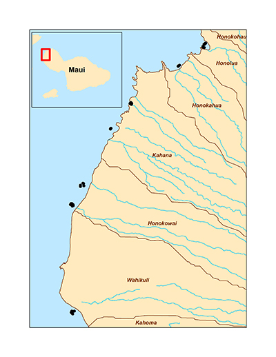
| Graphic Preview Description | Map showing locations of surveys in West Maui, Hawaii for the NOAA Coral Reef Conservation Program (CRCP) funded project, "Determining Watershed Management Efficacy in West Maui". |
| Graphic Preview File | http://data.nodc.noaa.gov/coris/data/NOAA/nmfs/pifsc/cred/maui_watershed/BrowseGraphic_450.jpg |
| Graphic Preview Type | JPG |
| Harvest Object Id | bd1719f9-dee8-4077-9551-ec55710208aa |
| Harvest Source Id | c0beac72-5f43-4455-8c33-1b345fbc2dfe |
| Harvest Source Title | NMFS PIFSC |
| Licence | NOAA provides no warranty, nor accepts any liability occurring from any incomplete, incorrect, or misleading data, or from any incorrect, incomplete, or misleading use of the data. It is the responsibility of the user to determine whether or not the data is suitable for the intended purpose. |
| Lineage | The data described here were collected via Line-Point-Intercept (25-centimeter intervals) and photoquadrat surveys for benthic composition and community structure by the NOAA Coral Reef Ecosystem Program (CREP) following a slightly modified protocol to that established by the NOAA National Coral Reef Monitoring Program (NCRMP). |
| Metadata Language | eng |
| Metadata Type | geospatial |
| Old Spatial | {"type": "Polygon", "coordinates": [[[-156.692878, 20.908651], [-156.63948046, 20.908651], [-156.63948046, 21.01574298], [-156.692878, 21.01574298], [-156.692878, 20.908651]]]} |
| Progress | completed |
| Spatial Data Service Type | |
| Spatial Reference System | |
| Spatial Harvester | True |
| Temporal Extent Begin | 2014-06-29 |
| Temporal Extent End | 2014-07-03 |
Didn't find what you're looking for? Suggest a dataset here.

