Delta-X: Turbidity, Water and Air Pressure, Temperature, MRD, Louisiana, 2021, V4
Access & Use Information
Downloads & Resources
-
Google Scholar search resultsHTML
Search results for publications that cite this dataset by its DOI.
-
Download this datasetHTML
This link allows direct data access via Earthdata login
-
View documentation related to this datasetHTML
ORNL DAAC Data Set Documentation
-
This dataset's landing pageHTML
Data set Landing Page DOI URL
-
View documentation related to this datasetPDF
Delta-X: Turbidity, Water and Air Pressure, Temperature, MRD, Louisiana,...
-
Get a related visualizationPNG
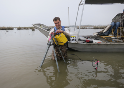
Installation of turbidity sensor in Mike Island study area of the Wax Lake...
-
The dataset's project home pageHTML
Delta-X Project Site
-
Landing PageLanding Page
Dates
| Metadata Created Date | October 4, 2023 |
|---|---|
| Metadata Updated Date | December 7, 2023 |
Metadata Source
- Data.json Data.json Metadata
Harvested from NASA Data.json
Graphic Preview

Additional Metadata
| Resource Type | Dataset |
|---|---|
| Metadata Created Date | October 4, 2023 |
| Metadata Updated Date | December 7, 2023 |
| Publisher | ORNL_DAAC |
| Maintainer | |
| Identifier | C2772853528-ORNL_CLOUD |
| Data First Published | 2023-09-21 |
| Language | en-US |
| Data Last Modified | 2023-09-26 |
| Category | Delta-X, geospatial |
| Public Access Level | public |
| Bureau Code | 026:00 |
| Metadata Context | https://project-open-data.cio.gov/v1.1/schema/catalog.jsonld |
| Metadata Catalog ID | https://data.nasa.gov/data.json |
| Schema Version | https://project-open-data.cio.gov/v1.1/schema |
| Catalog Describedby | https://project-open-data.cio.gov/v1.1/schema/catalog.json |
| Citation | Nghiem, J., G. Salter, K.A. Wright, P. Passalacqua, and M.P. Lamb. 2022. Delta-X: Turbidity, Water and Air Pressure, Temperature, MRD, Louisiana, 2021, V4. ORNL DAAC, Oak Ridge, Tennessee, USA. https://doi.org/10.3334/ORNLDAAC/2241 |
| Graphic Preview Description | Installation of turbidity sensor in Mike Island study area of the Wax Lake Delta in coastal Louisiana. |
| Graphic Preview File | https://daac.ornl.gov/DELTAX/guides/DeltaX_Turbidity_Data_V4_Fig1.png |
| Harvest Object Id | 30346ccb-9ed9-4819-9eed-9e82126fba71 |
| Harvest Source Id | 58f92550-7a01-4f00-b1b2-8dc953bd598f |
| Harvest Source Title | NASA Data.json |
| Homepage URL | https://doi.org/10.3334/ORNLDAAC/2241 |
| Metadata Type | geospatial |
| Old Spatial | -91.44 29.17 -90.82 29.51 |
| Program Code | 026:001 |
| Source Datajson Identifier | True |
| Source Hash | 4dbf0756f7f4fbbe792f943271bac12da0fc91b88a52bbb4b6d656aff8165c5b |
| Source Schema Version | 1.1 |
| Spatial | |
| Temporal | 2021-03-24T00:00:00Z/2021-08-27T23:59:59Z |
Didn't find what you're looking for? Suggest a dataset here.

