Delta-X: AVIRIS-NG L2B BRDF-Adjusted Surface Reflectance, MRD, LA, 2021, V2
Access & Use Information
Downloads & Resources
-
Google Scholar search resultsHTML
Search results for publications that cite this dataset by its DOI.
-
Download this datasetHTML
This link allows direct data access via Earthdata login
-
View documentation related to this datasetHTML
ORNL DAAC Data Set Documentation
-
This dataset's landing pageHTML
Data set Landing Page DOI URL
-
View documentation related to this datasetPDF
Delta-X: AVIRIS-NG L2B BRDF-Adjusted Surface Reflectance, MRD, LA, 2021, V2:...
-
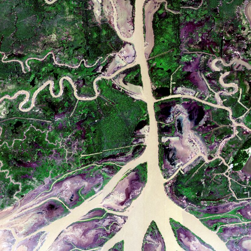
Get a related visualizationJPEG
Figure 1: A BRDF and sunglint-corrected image of the Atchafalaya basin.
-
The dataset's project home pageHTML
Delta-X Project Site
-
Landing PageLanding Page
Dates
| Metadata Created Date | June 27, 2023 |
|---|---|
| Metadata Updated Date | January 22, 2024 |
Metadata Source
- Data.json Data.json Metadata
Harvested from NASA Data.json
Graphic Preview

Additional Metadata
| Resource Type | Dataset |
|---|---|
| Metadata Created Date | June 27, 2023 |
| Metadata Updated Date | January 22, 2024 |
| Publisher | ORNL_DAAC |
| Maintainer | |
| Identifier | C2707162636-ORNL_CLOUD |
| Data First Published | 2024-01-12 |
| Language | en-US |
| Data Last Modified | 2024-01-16 |
| Category | Delta-X, geospatial |
| Public Access Level | public |
| Bureau Code | 026:00 |
| Metadata Context | https://project-open-data.cio.gov/v1.1/schema/catalog.jsonld |
| Metadata Catalog ID | https://data.nasa.gov/data.json |
| Schema Version | https://project-open-data.cio.gov/v1.1/schema |
| Catalog Describedby | https://project-open-data.cio.gov/v1.1/schema/catalog.json |
| Citation | Thompson, D.R., D.J. Jensen, J.W. Chapman, M. Simard, and E. Greenberg. 2023. Delta-X: AVIRIS-NG L2B BRDF-Adjusted Surface Reflectance, MRD, LA, 2021, V2. ORNL DAAC, Oak Ridge, Tennessee, USA. https://doi.org/10.3334/ORNLDAAC/2139 |
| Graphic Preview Description | Figure 1: A BRDF and sunglint-corrected image of the Atchafalaya basin. |
| Graphic Preview File | https://daac.ornl.gov/DELTAX/guides/DeltaX_L2A_AVIRIS-NG_BRDF_V2_Fig1.jpg |
| Harvest Object Id | 61c56679-4945-4167-a49b-e03fde4260d7 |
| Harvest Source Id | 58f92550-7a01-4f00-b1b2-8dc953bd598f |
| Harvest Source Title | NASA Data.json |
| Homepage URL | https://doi.org/10.3334/ORNLDAAC/2139 |
| Metadata Type | geospatial |
| Old Spatial | -91.59 29.05 -89.67 29.85 |
| Program Code | 026:001 |
| Source Datajson Identifier | True |
| Source Hash | 393c14c78582b5606f03a9ea0ec804eb1fb81d4bd88f6f55dabeac2108618300 |
| Source Schema Version | 1.1 |
| Spatial | |
| Temporal | 2021-03-27T00:00:00Z/2021-09-25T23:59:59Z |
Didn't find what you're looking for? Suggest a dataset here.

