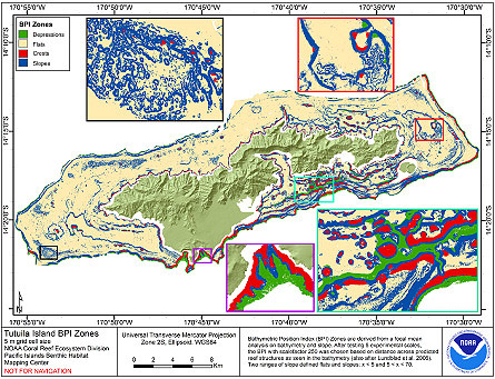
CRED Bathymetric Position Index (BPI) Zones grid derived from gridded bathymetry of Tutuila Island, American Samoa, South Pacific
Access & Use Information
Downloads & Resources
-
Web PageHTML
pibhmc_amsamoa_tutuila_geomorph.htm
-
Zip FileZIP
Tutuila_5m_BPIzones.zip
Dates
| Metadata Date | May 29, 2024 |
|---|---|
| Metadata Created Date | May 24, 2024 |
| Metadata Updated Date | May 24, 2024 |
| Reference Date(s) | January 15, 2007 (publication) |
| Frequency Of Update | asNeeded |
Metadata Source
- ISO-19139 ISO-19139 Metadata
Harvested from CoRIS FGDC Metadata
Graphic Preview

Additional Metadata
| Resource Type | Dataset |
|---|---|
| Metadata Date | May 29, 2024 |
| Metadata Created Date | May 24, 2024 |
| Metadata Updated Date | May 24, 2024 |
| Reference Date(s) | January 15, 2007 (publication) |
| Responsible Party | Pacific Islands Benthic Habitat Mapping Center (PIBHMC), Coral Reef Ecosystem Division (CRED), Pacific Islands Fisheries Science Center (PIFSC), National Marine Fisheries Service (NMFS), National Oceanic and Atmospheric Administration (NOAA) (Point of Contact) |
| Contact Email | |
| Guid | gov.noaa.crcp:tutuila_5m_bpizones.jpg |
| Access Constraints | Use Constraints: These data are not to be used for navigation purposes. Please acknowledge the NOAA Pacific Islands Fisheries Science Center (PIFSC) Coral Reef Ecosystem Division (CRED) and the Pacific Islands Benthic Habitat Mapping Center, and the Joint Institute for Marine and Atmospheric Research (JIMAR) and School of Ocean and Earth Science and Technology (SOEST), University of Hawaii as the sources of this information., Access Constraints: None |
| Bbox East Long | -170.484814 |
| Bbox North Lat | -14.195351 |
| Bbox South Lat | -14.384053 |
| Bbox West Long | -170.928197 |
| Coupled Resource | |
| Frequency Of Update | asNeeded |
| Graphic Preview Description | Gridded Bathymetry |
| Graphic Preview File | http://www.soest.hawaii.edu/pibhmc/amsamoa_images/Tutuila_5m_BPIzones_445.jpg |
| Graphic Preview Type | JPG |
| Harvest Object Id | bf7c2db5-1697-452b-b659-b06b3aa6e50d |
| Harvest Source Id | d96f14c5-3e35-4b0a-a3b8-9392afeb50fa |
| Harvest Source Title | CoRIS FGDC Metadata |
| Licence | These data are not to be used for navigational purposes. NOAA makes no warranty regarding these data, expressed or implied, nor does the fact of distribution constitute such a warranty. NOAA cannot assume liability for any damages caused by any errors or omissions in these data, nor as a result of the failure of these data to function on a particular system. |
| Lineage | |
| Metadata Language | eng; USA |
| Metadata Type | geospatial |
| Old Spatial | {"type": "Polygon", "coordinates": [[[-170.928197, -14.384053], [-170.484814, -14.384053], [-170.484814, -14.195351], [-170.928197, -14.195351], [-170.928197, -14.384053]]]} |
| Progress | completed |
| Spatial Data Service Type | |
| Spatial Reference System | urn:ogc:def:crs:EPSG::4326 |
| Spatial Harvester | True |
| Temporal Extent Begin | 2004-01-30 |
| Temporal Extent End | 2007-01-12 |
Didn't find what you're looking for? Suggest a dataset here.

