

Conductance Steamflow Relationship
Access & Use Information
Public: This dataset is intended for public access and use.
License:
Creative Commons Attribution
Downloads & Resources
-
Steam Flow vs Conductance Histogram.pngPNG
Relationship between electrical conductance and observed steam flow from...
-
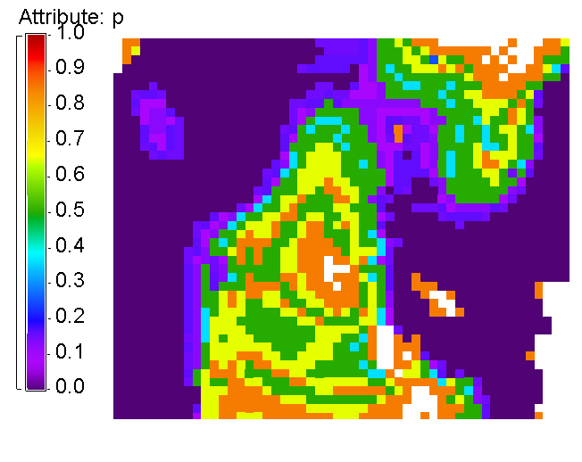
Probability Steam Flow Magnitude.pngPNG
This map displays the probability of steam flow given the calibration of...
-
Landing PageLanding Page
Dates
| Metadata Created Date | January 11, 2025 |
|---|---|
| Metadata Updated Date | January 20, 2025 |
Metadata Source
- Data.json Data.json Metadata
Harvested from OpenEI data.json
Additional Metadata
| Resource Type | Dataset |
|---|---|
| Metadata Created Date | January 11, 2025 |
| Metadata Updated Date | January 20, 2025 |
| Publisher | Lawrence Livermore National Laboratory |
| Maintainer | |
| Doi | 10.15121/1179036 |
| Identifier | https://data.openei.org/submissions/6794 |
| Data First Published | 2015-04-01T06:00:00Z |
| Data Last Modified | 2017-07-10T13:51:56Z |
| Public Access Level | public |
| Bureau Code | 019:20 |
| Metadata Context | https://openei.org/data.json |
| Metadata Catalog ID | https://openei.org/data.json |
| Schema Version | https://project-open-data.cio.gov/v1.1/schema |
| Catalog Describedby | https://project-open-data.cio.gov/v1.1/schema/catalog.json |
| Data Quality | True |
| Datagov Dedupe Retained | 20250120143002 |
| Harvest Object Id | 4f6ed6f4-e0c8-4c80-a586-fadc07e897c6 |
| Harvest Source Id | 7cbf9085-0290-4e9f-bec1-91653baeddfd |
| Harvest Source Title | OpenEI data.json |
| Homepage URL | https://gdr.openei.org/submissions/486 |
| License | https://creativecommons.org/licenses/by/4.0/ |
| Old Spatial | {"type":"Polygon","coordinates":107.59276986122,-6.6820676580086,107.59276986122,-6.6820676580086,107.59276986122,-6.6820676580086,107.59276986122,-6.6820676580086,107.59276986122,-6.6820676580086} |
| Program Code | 019:006 |
| Projectlead | Eric Hass |
| Projectnumber | FY14 AOP 3.6.1.2 |
| Projecttitle | Value of Information Evaluation |
| Source Datajson Identifier | True |
| Source Hash | 2785c877f3fb0416ae18935d16ab5e06cf29a727a8f256c4b0b78675a688b187 |
| Source Schema Version | 1.1 |
| Spatial | {"type":"Polygon","coordinates":107.59276986122,-6.6820676580086,107.59276986122,-6.6820676580086,107.59276986122,-6.6820676580086,107.59276986122,-6.6820676580086,107.59276986122,-6.6820676580086} |
Didn't find what you're looking for? Suggest a dataset here.