

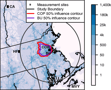
CO2 Observations, Modeled Emissions, and NAM-HYSPLIT Footprints, Boston MA, 2013-2014
Access & Use Information
Public: This dataset is intended for public access and use.
License: No license information was provided. If this work was prepared by an officer or employee of the United States government as part of that person's official duties it is considered a U.S. Government Work.
Downloads & Resources
-
Data Information (Unknown Format)BIN
-
Data Information (HTML)HTML
-
Data Information (PNG)PNG
NACP_NAM_HYSPLIT_Footprints_Fig1.png
-
Data Information (PDF)PDF
NACP_NAM_HYSPLIT_Footprints.pdf
-
Landing PageLanding Page
Dates
| Metadata Created Date | April 11, 2025 |
|---|---|
| Metadata Updated Date | August 29, 2025 |
Metadata Source
- Data.json Data.json Metadata
Harvested from NASA Data.json
Additional Metadata
| Resource Type | Dataset |
|---|---|
| Metadata Created Date | April 11, 2025 |
| Metadata Updated Date | August 29, 2025 |
| Publisher | ORNL_DAAC |
| Maintainer | |
| Identifier | 10.3334/ORNLDAAC/1586 |
| Data Last Modified | 2025-08-27 |
| Category | Earth Science |
| Public Access Level | public |
| Bureau Code | 026:00 |
| Metadata Context | https://project-open-data.cio.gov/v1.1/schema/catalog.jsonld |
| Schema Version | https://project-open-data.cio.gov/v1.1/schema |
| Catalog Describedby | https://project-open-data.cio.gov/v1.1/schema/catalog.json |
| Harvest Object Id | 623694b8-7207-407c-ba91-e10d2b255fb7 |
| Harvest Source Id | 58f92550-7a01-4f00-b1b2-8dc953bd598f |
| Harvest Source Title | NASA Data.json |
| Homepage URL | https://search.earthdata.nasa.gov/search?q=NACP_NAM_HYSPLIT_Footprints_1586&ac=true |
| Old Spatial | {"WestBoundingCoordinate":-72.18,"NorthBoundingCoordinate":43.709,"EastBoundingCoordinate":-70.0,"SouthBoundingCoordinate":41.35},"CARTESIAN" |
| Program Code | 026:000 |
| Source Datajson Identifier | True |
| Source Hash | e84aa56832bd2e7cda40803441ef397d0919b4188743563b7a86ce84c3848398 |
| Source Schema Version | 1.1 |
| Spatial | |
| Temporal | 2013-09-01/2013-09-01 |
Didn't find what you're looking for? Suggest a dataset here.