CMS: Daily Gross Primary Productivity over CONUS from TROPOMI SIF, 2018-2021
Access & Use Information
Downloads & Resources
-
Google Scholar search resultsHTML
Search results for publications that cite this dataset by its DOI.
-
Download this datasetHTML
This link allows direct data access via Earthdata login
-
View documentation related to this datasetHTML
ORNL DAAC Data Set Documentation
-
This dataset's landing pageHTML
Data set Landing Page DOI URL
-
Use OPeNDAP to access the dataset's dataHTML
USE SERVICE API
-
View documentation related to this datasetPDF
CMS: Daily Gross Primary Productivity over CONUS from TROPOMI SIF, 2018-2021:...
-
View documentation related to this datasetMP4
CMS: Daily Gross Primary Productivity over CONUS from TROPOMI SIF, 2018-2021:...
-
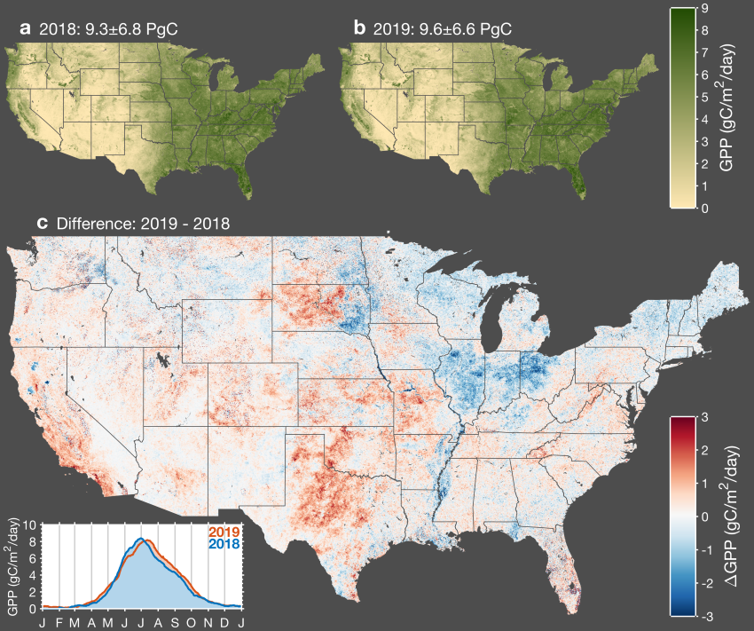
Get a related visualizationPNG
Interannual variation in gross primary productivity (GPP) across conterminous...
-
Landing PageLanding Page
Dates
| Metadata Created Date | December 1, 2022 |
|---|---|
| Metadata Updated Date | December 7, 2023 |
Metadata Source
- Data.json Data.json Metadata
Harvested from NASA Data.json
Graphic Preview

Additional Metadata
| Resource Type | Dataset |
|---|---|
| Metadata Created Date | December 1, 2022 |
| Metadata Updated Date | December 7, 2023 |
| Publisher | ORNL_DAAC |
| Maintainer | |
| Identifier | C2390701035-ORNL_CLOUD |
| Data First Published | 2022-04-07 |
| Language | en-US |
| Data Last Modified | 2023-07-17 |
| Category | CMS, geospatial |
| Public Access Level | public |
| Bureau Code | 026:00 |
| Metadata Context | https://project-open-data.cio.gov/v1.1/schema/catalog.jsonld |
| Metadata Catalog ID | https://data.nasa.gov/data.json |
| Schema Version | https://project-open-data.cio.gov/v1.1/schema |
| Catalog Describedby | https://project-open-data.cio.gov/v1.1/schema/catalog.json |
| Citation | Turner, A.J., P. Koehler, T. Magney, C. Frankenberg, I. Fung, and R.C. Cohen. 2021. CMS: Daily Gross Primary Productivity over CONUS from TROPOMI SIF, 2018-2021. ORNL DAAC, Oak Ridge, Tennessee, USA. https://doi.org/10.3334/ORNLDAAC/1875 |
| Graphic Preview Description | Interannual variation in gross primary productivity (GPP) across conterminous United States. Map of annual mean GPP for 2018 (a) and 2019 (b). Map of the difference in annual mean GPP between 2019 and 2018 (c) wherein red indicates higher GPP in 2019 and blue indicates higher GPP in 2018. The inset in the bottom left corner shows a time series of the average GPP across CONUS for 2018 and 2019. Source: Turner et al. (2021) |
| Graphic Preview File | https://daac.ornl.gov/CMS/guides/GPP_CONUS_TROPOMI_Fig1.png |
| Harvest Object Id | 8cd075f2-2fb0-42c9-9630-bb684258e282 |
| Harvest Source Id | 58f92550-7a01-4f00-b1b2-8dc953bd598f |
| Harvest Source Title | NASA Data.json |
| Homepage URL | https://doi.org/10.3334/ORNLDAAC/1875 |
| Metadata Type | geospatial |
| Old Spatial | -125.0 24.0 -65.0 50.0 |
| Program Code | 026:001 |
| Source Datajson Identifier | True |
| Source Hash | 3d64a233df4ca8cac6c958bc95f1725453163efb129795072548abf0e09cb0e6 |
| Source Schema Version | 1.1 |
| Spatial | |
| Temporal | 2018-02-15T00:00:00Z/2021-10-15T23:59:59Z |
Didn't find what you're looking for? Suggest a dataset here.

