

CAMEX-4 CVI CLOUD CONDENSED WATER CONTENT V1
Access & Use Information
Public: This dataset is intended for public access and use.
License: No license information was provided. If this work was prepared by an officer or employee of the United States government as part of that person's official duties it is considered a U.S. Government Work.
Downloads & Resources
-
Google Scholar search resultsHTML
Search results for publications that cite this dataset by its DOI.
-
Download this datasetHTML
Files may be downloaded directly to your workstation from this link
-
View documentation related to this datasetHTML
The guide document contains detailed information about the dataset
-
View the primary investigator's documentation...JPEG
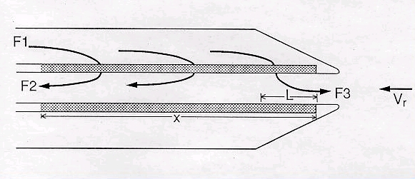
CAMEX-4 Counterflow Virtual Impactor Cartoon (JPG)
-
View the primary investigator's documentation...PDF
The Counterflow Virtual Impactor (CVI)
-
The dataset's project home pageHTML
The home page for the project or program which sponsored the dataset
-
View documentation related to this datasetHTML
Instructions for citing GHRC data
-
Landing PageLanding Page
Dates
| Metadata Created Date | December 1, 2022 |
|---|---|
| Metadata Updated Date | December 6, 2023 |
Metadata Source
- Data.json Data.json Metadata
Harvested from NASA Data.json
Additional Metadata
| Resource Type | Dataset |
|---|---|
| Metadata Created Date | December 1, 2022 |
| Metadata Updated Date | December 6, 2023 |
| Publisher | NASA/MSFC/GHRC |
| Maintainer | |
| Identifier | C1979094668-GHRC_DAAC |
| Data First Published | 2002-11-15 |
| Language | en-US |
| Data Last Modified | 2022-05-18 |
| Category | CAMEX-4, geospatial |
| Public Access Level | public |
| Bureau Code | 026:00 |
| Metadata Context | https://project-open-data.cio.gov/v1.1/schema/catalog.jsonld |
| Metadata Catalog ID | https://data.nasa.gov/data.json |
| Schema Version | https://project-open-data.cio.gov/v1.1/schema |
| Catalog Describedby | https://project-open-data.cio.gov/v1.1/schema/catalog.json |
| Citation | Twohy, Cynthia H.2002. CAMEX-4 CVI CLOUD CONDENSED WATER CONTENT indicate subset used. Dataset available online from the NASA Global Hydrometeorology Resource Center DAAC, Huntsville, Alabama, U.S.A. DOI: http://dx.doi.org/10.5067/CAMEX-4/CVI/DATA201 |
| Harvest Object Id | 85cf3894-8c91-4c41-9ce7-7010a3d6a5c3 |
| Harvest Source Id | 58f92550-7a01-4f00-b1b2-8dc953bd598f |
| Harvest Source Title | NASA Data.json |
| Homepage URL | https://doi.org/10.5067/CAMEX-4/CVI/DATA201 |
| Metadata Type | geospatial |
| Old Spatial | -84.4033 24.455 -58.635 39.0433 |
| Program Code | 026:001 |
| Source Datajson Identifier | True |
| Source Hash | aee2202fa7e480e4ce28cc908e6b3312c9479bb638b17ccf4ced4e6c081b9750 |
| Source Schema Version | 1.1 |
| Spatial | |
| Temporal | 2001-09-06T16:45:40Z/2001-09-10T22:11:21Z |
Didn't find what you're looking for? Suggest a dataset here.