AVIRIS-3 L2B Greenhouse Gas Enhancements, Facility Instrument Collection
Access & Use Information
Downloads & Resources
-
Google Scholar search resultsHTML
Search results for publications that cite this dataset by its DOI.
-
Download this datasetHTML
This link allows direct data access via Earthdata login
-
View documentation related to this datasetHTML
ORNL DAAC Data Set Documentation
-
This dataset's landing pageHTML
Data set Landing Page DOI URL
-
View documentation related to this datasetPDF
AVIRIS-3 L2B Greenhouse Gas Enhancements, Facility Instrument Collection:...
-
Get a related visualizationJPEG
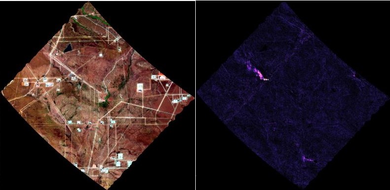
False color image from orthocorrected radiance (left) and methane enhancement...
-
Landing PageLanding Page
Dates
| Metadata Created Date | September 16, 2024 |
|---|---|
| Metadata Updated Date | October 15, 2024 |
Metadata Source
- Data.json Data.json Metadata
Harvested from NASA Data.json
Graphic Preview

Additional Metadata
| Resource Type | Dataset |
|---|---|
| Metadata Created Date | September 16, 2024 |
| Metadata Updated Date | October 15, 2024 |
| Publisher | ORNL_DAAC |
| Maintainer | |
| Identifier | C3236537512-ORNL_CLOUD |
| Data First Published | 2024-09-06 |
| Language | en-US |
| Data Last Modified | 2024-10-07 |
| Category | AVIRIS, geospatial |
| Public Access Level | public |
| Bureau Code | 026:00 |
| Metadata Context | https://project-open-data.cio.gov/v1.1/schema/catalog.jsonld |
| Metadata Catalog ID | https://data.nasa.gov/data.json |
| Schema Version | https://project-open-data.cio.gov/v1.1/schema |
| Catalog Describedby | https://project-open-data.cio.gov/v1.1/schema/catalog.json |
| Citation | Chlus, A.M., P.G. Brodrick, A.K. Thorpe, J.W. Chapman, D.J. Jensen, R.W. Coleman, J. Fahlen, W. Olson-Duvall, D.R. Thompson, and R.O. Green. 2024. AVIRIS-3 L2B Greenhouse Gas Enhancements, Facility Instrument Collection. ORNL DAAC, Oak Ridge, Tennessee, USA. https://doi.org/10.3334/ORNLDAAC/2358 |
| Graphic Preview Description | False color image from orthocorrected radiance (left) and methane enhancement (right) from AVIRIS-3 data acquired on 2024-06-07 over the Gulf of Mexico about 10 km east of the Mississippi River Delta (approximately 29.10 latitude, -88.76 longitude). The enhancement image shows a methane plume associated with a oil rig visible in the upper central portion of false color image. Flight scene AV320240607t164125_003. |
| Graphic Preview File | https://daac.ornl.gov/AVIRIS/guides/AV3_L2B_GHG_Fig1.jpg |
| Harvest Object Id | f3cb7b35-aa50-4466-b545-564372b904f0 |
| Harvest Source Id | 58f92550-7a01-4f00-b1b2-8dc953bd598f |
| Harvest Source Title | NASA Data.json |
| Homepage URL | https://doi.org/10.3334/ORNLDAAC/2358 |
| Metadata Type | geospatial |
| Old Spatial | -178.68 16.5 -66.18 72.6 |
| Program Code | 026:001 |
| Source Datajson Identifier | True |
| Source Hash | 59abcfcb455685d462e488416a04ad0532bce5650af73e19511cc50b9bd24a70 |
| Source Schema Version | 1.1 |
| Spatial | |
| Temporal | 2023-07-05T00:00:00Z/2024-10-14T00:00:00Z |
Didn't find what you're looking for? Suggest a dataset here.

