ATom: Black Carbon Mass Mixing Ratios from ATom-1 Flights
Access & Use Information
Downloads & Resources
-
Google Scholar search resultsHTML
Search results for publications that cite this dataset by its DOI.
-
Download this datasetHTML
This link allows direct data access via Earthdata login
-
View documentation related to this datasetHTML
ORNL DAAC Data Set Documentation
-
This dataset's landing pageHTML
Data set Landing Page DOI URL
-
View documentation related to this datasetPDF
ATom: Black Carbon Mass Mixing Ratios from SP2 and PALMS for ATom-1 Flights:...
-
Get a related visualizationPNG
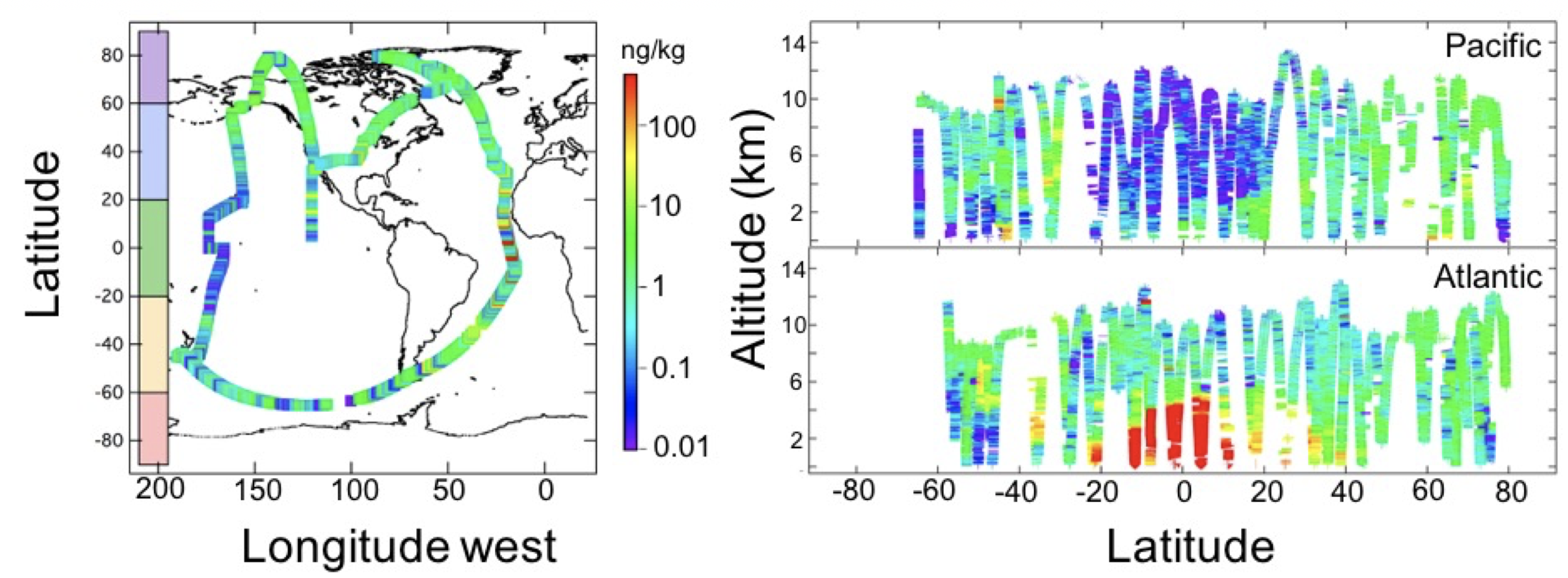
Figure 1: Left: Flight tracks (colored line) of the NASA DC-8 during the...
-
The dataset's project home pageHTML
ATom campaign page
-
Landing PageLanding Page
Dates
| Metadata Created Date | May 30, 2023 |
|---|---|
| Metadata Updated Date | December 6, 2023 |
Metadata Source
- Data.json Data.json Metadata
Harvested from NASA Data.json
Graphic Preview

Additional Metadata
| Resource Type | Dataset |
|---|---|
| Metadata Created Date | May 30, 2023 |
| Metadata Updated Date | December 6, 2023 |
| Publisher | ORNL_DAAC |
| Maintainer | |
| Identifier | C2675840774-ORNL_CLOUD |
| Data First Published | 2018-09-18 |
| Language | en-US |
| Data Last Modified | 2023-06-12 |
| Category | ATom, geospatial |
| Public Access Level | public |
| Bureau Code | 026:00 |
| Metadata Context | https://project-open-data.cio.gov/v1.1/schema/catalog.jsonld |
| Metadata Catalog ID | https://data.nasa.gov/data.json |
| Schema Version | https://project-open-data.cio.gov/v1.1/schema |
| Catalog Describedby | https://project-open-data.cio.gov/v1.1/schema/catalog.json |
| Citation | Katich, J.M., J.P. Schwarz, K. Froyd, B. Weinzierl, M. Dollner, T.P. Bui, C.S. Chang, and J.M. Dean-Day. 2018. ATom: Black Carbon Mass Mixing Ratios from ATom-1 Flights. ORNL DAAC, Oak Ridge, Tennessee, USA. https://doi.org/10.3334/ORNLDAAC/1618 |
| Graphic Preview Description | Figure 1: Left: Flight tracks (colored line) of the NASA DC-8 during the ATom-1 deployment. Right: Altitude vs latitude for the Pacific (top) and Atlantic (bottom) basins. Color in both figures represents black carbon mass-mixing ratio in units of ng rBC/kg of air. |
| Graphic Preview File | https://daac.ornl.gov/ATOM/guides/ATom_Carbon_Aerosol_Loadings_Fig1.png |
| Harvest Object Id | 13661c4c-2a81-409f-a4f5-2486d9e98468 |
| Harvest Source Id | 58f92550-7a01-4f00-b1b2-8dc953bd598f |
| Harvest Source Title | NASA Data.json |
| Homepage URL | https://doi.org/10.3334/ORNLDAAC/1618 |
| Metadata Type | geospatial |
| Old Spatial | -180.0 -65.33 178.99 80.0 |
| Program Code | 026:001 |
| Source Datajson Identifier | True |
| Source Hash | 7e47ccc48cc42adb986f01fe80f07e86cfcb187ea3d1df30d6663f93f5ae0e87 |
| Source Schema Version | 1.1 |
| Spatial | |
| Temporal | 2016-07-29T00:00:00Z/2016-08-23T23:59:59Z |
Didn't find what you're looking for? Suggest a dataset here.

