

Aquarius CAP Level 3 Sea Surface Salinity Rain Corrected Standard Mapped Image 7-Day Data V5.0
Access & Use Information
Public: This dataset is intended for public access and use.
License: No license information was provided. If this work was prepared by an officer or employee of the United States government as part of that person's official duties it is considered a U.S. Government Work.
Downloads & Resources
-
Data Information (Unknown Format)BIN
-
Data Information (Unknown Format)BIN
-
Data Information (Unknown Format)BIN
-
Data Information (PDF)PDF
Aquarius-CAP-User-Guide-v5.0.pdf
-
Data Information (Unknown Format)BIN
-
Data Information (Unknown Format)BIN
-
Data Information (Unknown Format)BIN
-
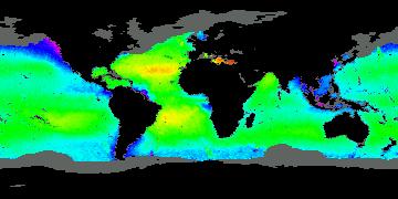
Data Information (JPEG)JPEG
AQUARIUS_L3_SSS_RAINCORRECTED_CAP_7DAY_V5.jpg
-
Landing PageLanding Page
Dates
| Metadata Created Date | April 11, 2025 |
|---|---|
| Metadata Updated Date | September 19, 2025 |
Metadata Source
- Data.json Data.json Metadata
Harvested from NASA Data.json
Additional Metadata
| Resource Type | Dataset |
|---|---|
| Metadata Created Date | April 11, 2025 |
| Metadata Updated Date | September 19, 2025 |
| Publisher | Aquarius Project NASA/CONAE, JPL;NASA/JPL/PODAAC |
| Maintainer | |
| Identifier | 10.5067/AQR50-3Q7CS |
| Data Last Modified | 2025-09-10 |
| Category | Earth Science |
| Public Access Level | public |
| Bureau Code | 026:00 |
| Metadata Context | https://project-open-data.cio.gov/v1.1/schema/catalog.jsonld |
| Schema Version | https://project-open-data.cio.gov/v1.1/schema |
| Catalog Describedby | https://project-open-data.cio.gov/v1.1/schema/catalog.json |
| Harvest Object Id | 178d575e-a5e5-485b-afcf-6b58bcb631d7 |
| Harvest Source Id | 58f92550-7a01-4f00-b1b2-8dc953bd598f |
| Harvest Source Title | NASA Data.json |
| Homepage URL | https://podaac.jpl.nasa.gov/CitingPODAAC |
| Old Spatial | {"EastBoundingCoordinate":180.0,"NorthBoundingCoordinate":90,"SouthBoundingCoordinate":-90,"WestBoundingCoordinate":-180.0},"CARTESIAN" |
| Program Code | 026:000 |
| Source Datajson Identifier | True |
| Source Hash | eb96fd28fd9985afdec6ba93cb48a11331847b2cdf6447175a2f6f347b29e634 |
| Source Schema Version | 1.1 |
| Spatial | |
| Temporal | 2011-08-26/2011-08-26 |
Didn't find what you're looking for? Suggest a dataset here.