An Unexpectedly Large Count of Trees in the West African Sahara and Sahel
Access & Use Information
Downloads & Resources
-
Google Scholar search resultsHTML
Search results for publications that cite this dataset by its DOI.
-
Download this datasetHTML
This link allows direct data access via Earthdata login
-
View documentation related to this datasetHTML
ORNL DAAC Data Set Documentation
-
This dataset's landing pageHTML
Data set Landing Page DOI URL
-
View documentation related to this datasetHTML
An Unexpectedly Large Count of Trees in the West African Sahara and Sahel:...
-
View documentation related to this datasetPDF
An Unexpectedly Large Count of Trees in the West African Sahara and Sahel:...
-
Get a related visualizationPNG
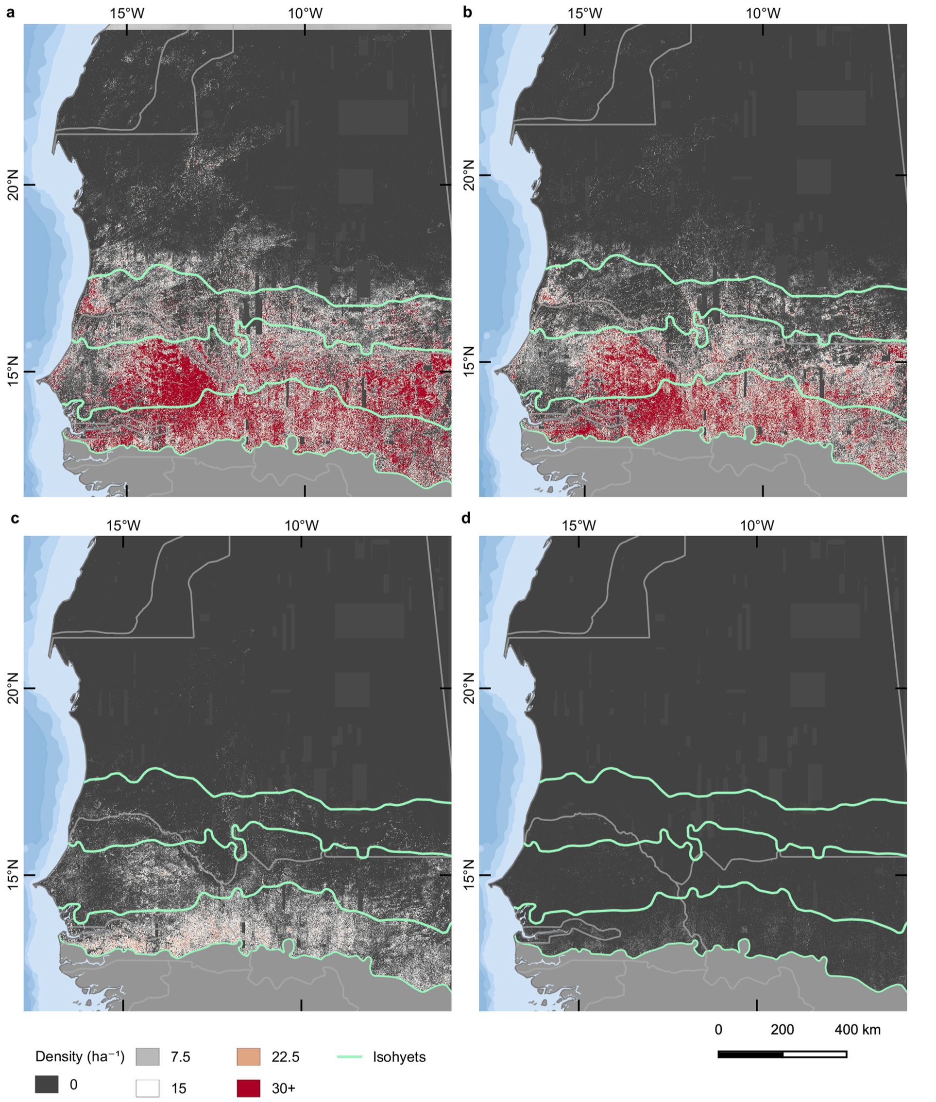
The tree density per hectare is shown for different crown size classes: (a)...
-
Landing PageLanding Page
Dates
| Metadata Created Date | September 14, 2023 |
|---|---|
| Metadata Updated Date | December 6, 2023 |
Metadata Source
- Data.json Data.json Metadata
Harvested from NASA Data.json
Graphic Preview

Additional Metadata
| Resource Type | Dataset |
|---|---|
| Metadata Created Date | September 14, 2023 |
| Metadata Updated Date | December 6, 2023 |
| Publisher | ORNL_DAAC |
| Maintainer | |
| Identifier | C2761798565-ORNL_CLOUD |
| Data First Published | 2020-12-03 |
| Language | en-US |
| Data Last Modified | 2023-09-06 |
| Category | Vegetation, geospatial |
| Public Access Level | public |
| Bureau Code | 026:00 |
| Metadata Context | https://project-open-data.cio.gov/v1.1/schema/catalog.jsonld |
| Metadata Catalog ID | https://data.nasa.gov/data.json |
| Schema Version | https://project-open-data.cio.gov/v1.1/schema |
| Catalog Describedby | https://project-open-data.cio.gov/v1.1/schema/catalog.json |
| Citation | Brandt, M., C.J. Tucker, A. Kariryaa, K. Rasmussen, C. Abel, J.L. Small, J. Chave, L.V. Rasmussen, P. Hiernaux, A.A. Diouf, L. Kergoat, O. Mertz, C. Igel, F. Gieseke, J. Schöning, S. Li, K.A. Melocik, J.R. Meyer, S. Sinno, E. Romero, E.N. Glennie, A. Montagu, M. Dendoncker, and R. Fensholt. 2020. An Unexpectedly Large Count of Trees in the West African Sahara and Sahel. ORNL DAAC, Oak Ridge, Tennessee, USA. https://doi.org/10.3334/ORNLDAAC/1832 |
| Graphic Preview Description | The tree density per hectare is shown for different crown size classes: (a) 3-15 m2, (b) 15-50 m2, (c) 50-200 m2, (d) >200 m2. Source: Brandt et al. (2020) |
| Graphic Preview File | https://daac.ornl.gov/VEGETATION/guides/Non-Forest_Trees_Sahara_Sahel_Fig1.png |
| Harvest Object Id | 0d3429ff-addc-4cae-8b2e-46c66c7123f6 |
| Harvest Source Id | 58f92550-7a01-4f00-b1b2-8dc953bd598f |
| Harvest Source Title | NASA Data.json |
| Homepage URL | https://doi.org/10.3334/ORNLDAAC/1832 |
| Metadata Type | geospatial |
| Old Spatial | -18.0 11.35 -5.49 24.03 |
| Program Code | 026:001 |
| Source Datajson Identifier | True |
| Source Hash | 63fc5a5c83f250f4c18515c8bacef2797990a7098cb9e424719d3981ba82143b |
| Source Schema Version | 1.1 |
| Spatial | |
| Temporal | 2005-11-01T00:00:00Z/2018-03-31T23:59:59Z |
Didn't find what you're looking for? Suggest a dataset here.

